Town on a Bridge (Work-in-Progress)

Inking all this took a little longer than I expected, but here’s the town on a bridge. There are two levels on top of the bridge deck and another one underneath. The town has a tavern, a livery, various shops, a few gardens and a few empty buildings so you can add in whatever you need that isn’t there.

I’ve got a little bit left to ink tonight and then I’ll start on the color tomorrow. Anyway, what do you think so far?

The Ruins of Gyan’dis

Here’s the unfurnished version.

Gyan’dis is a ruined illithid settlement in the Black Loch. The colony thrived in its corner of the loch for over 800 years, until it was brought down and its inhabitants wiped out by Gyan’dis’ own elder brain. Normally, I’d talk a little more about the background of the map, but I’m going to leave that for a day or so, because I’m planning on writing up an overview of the history and lore of the Black Loch, which I can probably get done sometime tomorrow.

It’ll have basic information on the loch, along with brief summaries of the locations I’ve drawn so far. I think it’ll be a good introductory overview of the setting, which should be useful to patrons and non-patrons alike. Also, for non-patrons, I promise it’ll explain more about why the elder brain destroyed its own colony. I wouldn’t leave you hanging like that.

Once that’s done, I’ll be getting started on last month’s Cartographic Congress winner, a town built on a bridge over a river canyon. I’ve been champing at the bit to get started on that and it’s taking all my willpower to write up the Black Loch overview first. But it’s long overdue, it needs to be done and it’s only a day’s work at most, so I’m just going to bite the bullet and get it written.

After the bridge, I’ll be drawing the next historical map, Scotland’s Coxton Tower. And then we’ll probably find our way back to the Underscotland for another piece of the Black Loch.

Sound like a plan? Either way, let me know what you think!

Ard Skellig

Here’s a map of the interiors of the buildings and here’s a map of just the island with nothing on it.

Of the many Irish isles, one would have stood out to ancient settlers as a particularly good place to live. With its rolling hills, thick forests and an abundance of arable land, it was exactly what many of them were looking for. The island was called “Ireland” and, conveniently, it was the big one in the middle.

But for some people, Ireland was a bit too easy. They were looking for a challenge. These people wanted to make their homes on a smaller island, several miles offshore. Maybe a steep, jagged rock jutting out of the sea, preferably with no trees, very little flat ground, and, of course, no farmable land. Because agriculture is basically cheating.

A little ways off Ireland’s southwest coast, they found exactly what they were looking for: Skellig Michael. They headed over, built themselves a few big, stone beehives to live in, and enjoyed spending the rest of their lives away from the fast-living, hectic lifestyle of rural Kerry.

Then, over 1000 years later, Luke Skywalker showed up. Seriously. If you recognize this place, that’s probably why. In 2015, part of Star Wars: The Force Awakens was filmed on Skellig Michael. And if the island’s name rings a bell, that’s probably because you’ve played the Witcher. The Kingdom of Skellige is named after it. I’m not sure how the producers of Star Wars or a Polish author even knew this place existed, but apparently it’s more famous than you’d expect.

Anyway, next, I’ll be drawing another map from the Black Loch. This time, I’ll be drawing the ruins of an Illithid settlement, which should be a pretty interesting place to explore. After that, I’m going to draw the map chosen by last month’s Cartographic Congress, which I am ridiculously excited about.

Once in a while, someone proposes something to the Cartographic Congress that’s very similar to an idea I’ve been wanting to draw for a while. And, once in a while, that proposal wins. This is that proposal: a town built on a bridge over a river canyon.

I’ve seen a couple maps based on similar ideas before, but I’ve got a whole different sort of thing planned. I’m planning to draw buildings along the sides of the bridge, plus a lower level underneath the bridge deck, and hollow spaces inside the support pylons. I want to have the settlement extend into the cliffsides beneath the bridge as well. I’ve got a big vision for this and I think it’s going to be really cool, either as a settlement or as a dungeon to explore.

Well, that’s it for now. Hope you like Ard Skellig. Let me know what you think!

Fort Bourtange – Roof Level and Dutch Version

Here’s the roof level, which is the last part of Fort Bourtange. I also made something else: an annotated version in Dutch, which I’m giving out to everyone.

I’m aware that everyone in the Netherlands under the age of 105 speaks perfect English along with 50 other languages, so I know you probably don’t need this, but I still thought it’d be nice to do. Plus, the English version comes from a Dutch tour map I translated, so I figured I could just not translate it and make a Dutch version that way. There are a couple things I had to use Google for, so I can’t promise it’s perfect, but let me know if anything is wrong or just super weird and I’ll fix it.

Anyway, the next map will be a demonologist’s lair, Remember A Dark Place? I’m gonna try to make someplace freakier than that. It’s not Hell, but it’s the home of… well, a big fan of Hell. A Hell stan, if you will. Hopefully I can come up with something uniquely terrible.

I’ve also got the next historical map picked out, which I’ll be doing sometime in the next few 2-3 months. This time, I’ll be drawing a place in Britain– or, more specifically, Scotland. There are some incredible places in Scotland, like Stirling Castle, the Wallace Monument, and about half the buildings in Edinburgh. Instead of drawing any of that stuff, I’m going to draw Coxton Tower. It’s a towerhouse in Moray and I think it’d make a great map. It’s not huge, complicated or flashy, but it’s interesting. It’s got some unique character, both inside and outside, and it’s the kind of place everyone can find a use for.

I don’t know exactly when I’ll start on it, but I definitely want to put some work in on the Black Loch first. That’s Scottish, too. Well, a little. I mean, it’s not the Black Lake. Anyway, I’m gonna go sketch out some freaky demon stuff. If you’ve got any thoughts on any of this, let me know!

Fort Bourtange

In the 1500s, the Netherlands were ruled by the Habsburgs. The Habsburgs were an astoundingly inbred German noble family with faces that were about 85% chin. For some reason, they were the rulers of the Spanish Empire.

The people of the the Low Countries didn’t want to be ruled by German people, Spanish people or inbred people, let alone a combination of the three. They wanted self-determination, a republic and the right to worship the protestant version of God. So, in the mid-1500s, the Dutch Revolt began.

The Spanish Empire ruled Spain, part of Italy, Austria, and– you know the countries that speak Spanish today? All of those. It was a daunting enemy, but the Low Countries had one thing going for them: stupefying amounts of money. And they planned to leverage that to win.

One of the things the Dutch spent that money on was Fort Bourtange. Since the Spanish were allied with the Holy Roman Empire, they’d need a way to protect the Dutch land from the Deutschland. One of the main roads to Germany passed through a marsh, so the leader of the revolt, Willem van Oranje, ordered the construction of a fort across it.

Building a star fort with forty buildings, a crownwork, four ravelins and two moats is an expensive operation. But not only did they build it, they built it on a sandbar in the middle of a marsh.

Fort Bourtange was such an obvious deathtrap that not many people were inclined to order their armies to assault it. But, about 100 years after its construction, Bernhard von Galen, the Prince-Bishop of Münster, came along to give it the old college try. During a parley before the attack, he told the fort’s commander, Captain Protts, he had 200,000 guilders for him if he’d surrender Bourtange. Protts famously responded by telling von Galen he had 200,000 bullets for him and his men. Von Galen decided to send his soldiers to go receive them, which resulted in a crushing defeat for his army. He then went on to besiege the nearby city of Groningen, which he also failed at.

In later years, the fort began to transition into a village, where the soldiers of the garrison lived with their families. Then, in the 1800s, the fort was turned into a village for local farmers.

Well, this map was a ton of work, but I hope you like it! I’m going to make a roof-level version of the fort next, which should only take a couple days, then I’ll be moving on to the next map. I plan to make a big push on getting some Black Loch maps done over the next few months as well.

Anyway, let me know what you think of Fort Bourtange!

There’s an annotated version of this map and DM notes available to patrons.
Glogdolp – Roofs

Not too much going on in the roof level, but there is one thing I wanted to mention. If you look around the buildings, you’ll see little triangles pointing to the walls. Those are to indicate where the doors are. It occurred to me recently that that might be useful for some people, so I decided to try it and see what you all think.

Anyway, next I’ll be drawing some tokens for the Black Loch. Drow and kuo-toa and Lim the Big Dumb Ogre and so forth. Those will probably be done in a day or two. After that, I’ll be drawing the map chosen by last month’s Cartographic Congress: a wizard’s casino. I’m thinking this is going to be more Monte Carlo than Vegas, but let’s see how it goes. In any case, after that, I think we’ll be headed back to the loch!

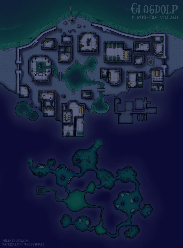
Glogdolp: A Kuo-Toa Village

Here’s the annotated version.

Glogdolp is a kuo-toa village in the Black Loch. The main things they do here are mollusk farming and slaving. That big jail isn’t there to deal with widespread naughtiness.

Glogdolp is at the tail end of a larger kuo-toan nation called the Bluescale Empire, which stretches down the river to the south. They don’t have much of a presence in the Loch at the moment, but they have plans to change that. Those plans aren’t really happening in Glogdolp, but when we get to the nearby kuo-toa stronghold, you’ll get a look at the kind of nonsense they have in mind.

Basically, it’s crabs. Huge crabs. Like, stupidly huge crabs. Siege crabs. The Bluescale Empire is secretly breeding them and, at some point, they intend to use them to take over the loch.

Personally, I think Glogdolp would be a good place for a rescue mission. The kind that starts with a few potions of water breathing, so the party can sneak in through the underwater caverns. Or you could even have the party stop here to ask about something, then have them happen to see a bunch of slaves getting led into the cells. You know, start pushing some emotional buttons, get an argument going between the paladin and the rogue. We have to save them! We totally don’t. My god says we do! I don’t care about your god. You did when he was curing your Thayvian Crotch Leprosy!

Next, I’m going to draw a roof-level map of Glogdolp, which should only take a day or two. After that, I’m going to draw some tokens. Specifically, I’m going to make tokens pertaining to the Black Loch. So, kuo-toa, Lim the Ogre,  the orogs and drow of the Deep Spire, and so forth. If I’m going to draw all the places in the Black Loch, I might as well draw the people as well. That shouldn’t take long either.

By the way, if you don’t know about the tokens I made, there are around 270 of them and they’re free. You can download them all here.

Anyway, I hope you like the map! Let me know what you think of the Black Loch so far!

There are DM notes for this map available to patrons.

Kuo Toa-Village – Work-In-Progress

I’m in the middle of coloring this at the moment. There are also a series of underwater caverns below, but I’ll show you those when it’s done.

The main thing the kuo-toa in this village do is capture travelers to serve as slaves or sacrifices. This is one of the reasons people stay at the godawful inn nearby. When the choice is either sleeping on a bed that smells like weapons-grade cat urine or getting brutally sacrificed to an imaginary fish goddess, most people would choose the former.

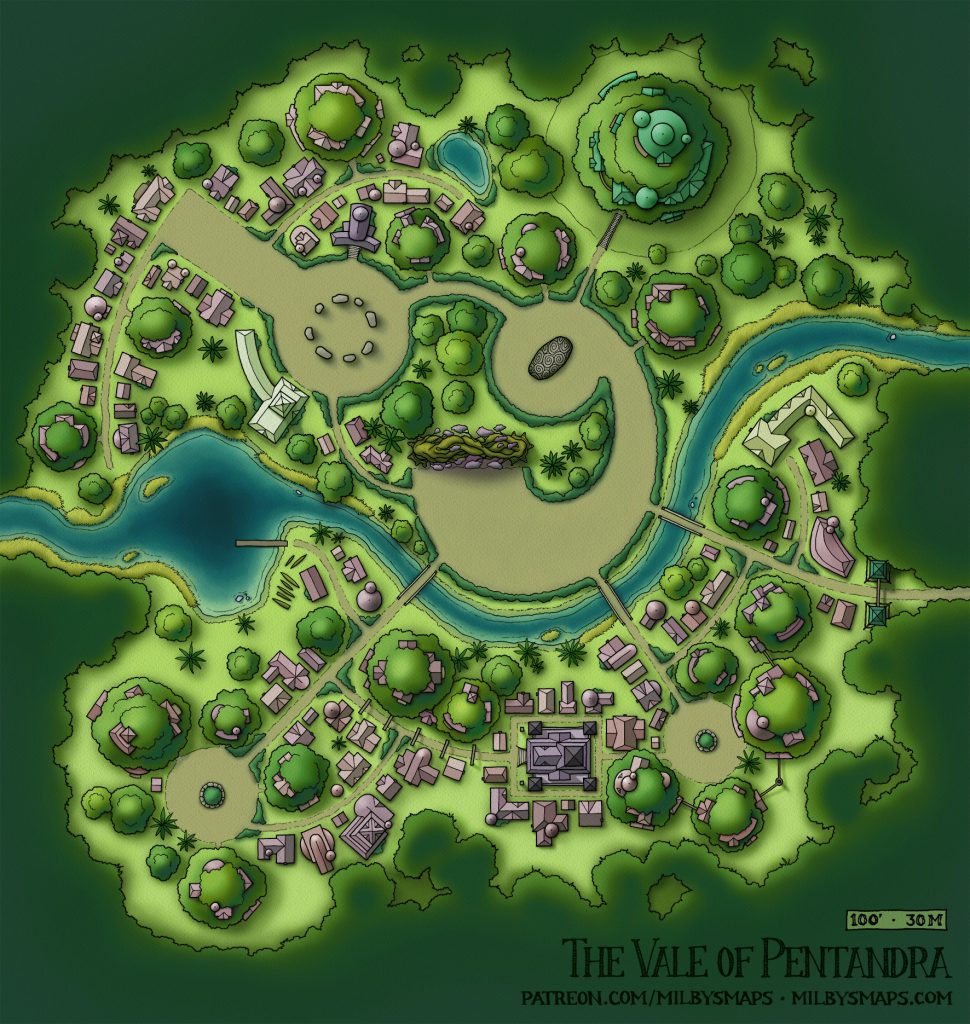
The Vale of Pentandra

The Vale of Pentandra was a map chosen by the Cartographic Congress. Ben, who proposed it, wanted an elven city in the rainforest with a magical portal in the center, surrounded by two huge trees arching overhead.

The more I’ve thought about it, the more I like the portal. Sometimes, as a DM, you want your players to be somewhere really far away. And you don’t want to say, “You get on your horses, clap the coconuts for two months and you’re there,” but you also might not want to do three sessions of “stuff happens while you’re on the road.” Having a way to avoid either of those things in a way that feels natural can be nice. Ready to stop doing Chult stuff and start doing Waterdeep stuff? This might be a nice place for the party to hear a rumor about.

I apologize for this taking so long, but I wanted to get it looking right and that required a lot of changing things around this time. Also– feel free to laugh at me– I got everything done an hour ago, was ready to post this, and realized I forgot to put a scale on it. I managed to forget about that for the entire week and a half it took me to plan, draw and color this. YEP THAT’S ME PROFESSIONAL FANTASY CARTOGRAPHER RIGHT HERE.

Anyway, I’ll be getting to work on the Black Loch next. I’m going to draw the inn on the left side of the map. I know there are a million maps of inns out there, but this one is going to be a little unusual, because this place is owned and operated by a clan of ogres. And it features only the finest ogre furnishings. Ogre-crafted tables. Ogre-crafted bar. Ogre-crafted doors and walls. Starting to get the picture? Your players think they’ve stayed at a crappy dump of an inn before. They have no idea.

The Deep Spire: All Levels

Here are the non-annotated version and the unfurnished version. Also, here are the DM notes in case you missed the last post.

Sorry, this took a bit longer than I expected, mostly due to the Photoshop-crashingly large size of the image file. As soon as the stores open back up, I’m buying a new computer. I bought my current one when my previous machine died and it’s still kicking, but it’s time for an upgrade. I haven’t bought anything other than food in almost a year, so as soon as the stores open back up, I’m going to the local indie computer place with the name that probably sounded super hi-tech in 1989 and I’m gonna tell them I need a machine that will literally melt a hole through my desk the second the video card starts running. I’m “supporting local businesses,” or at least that’s my excuse.

Anyway, there are a couple more things I still need to make for this, including some multi-floor maps. You can use this one with all the floors, of course, but I’m going to make some maps with three levels each as well. I think I can get all that posted later today.

Well, I hope you like the Deep Spire! It was a month’s work, but I think it’s a pretty good start to the Black Loch. Let me know what you think!