Templemore Village

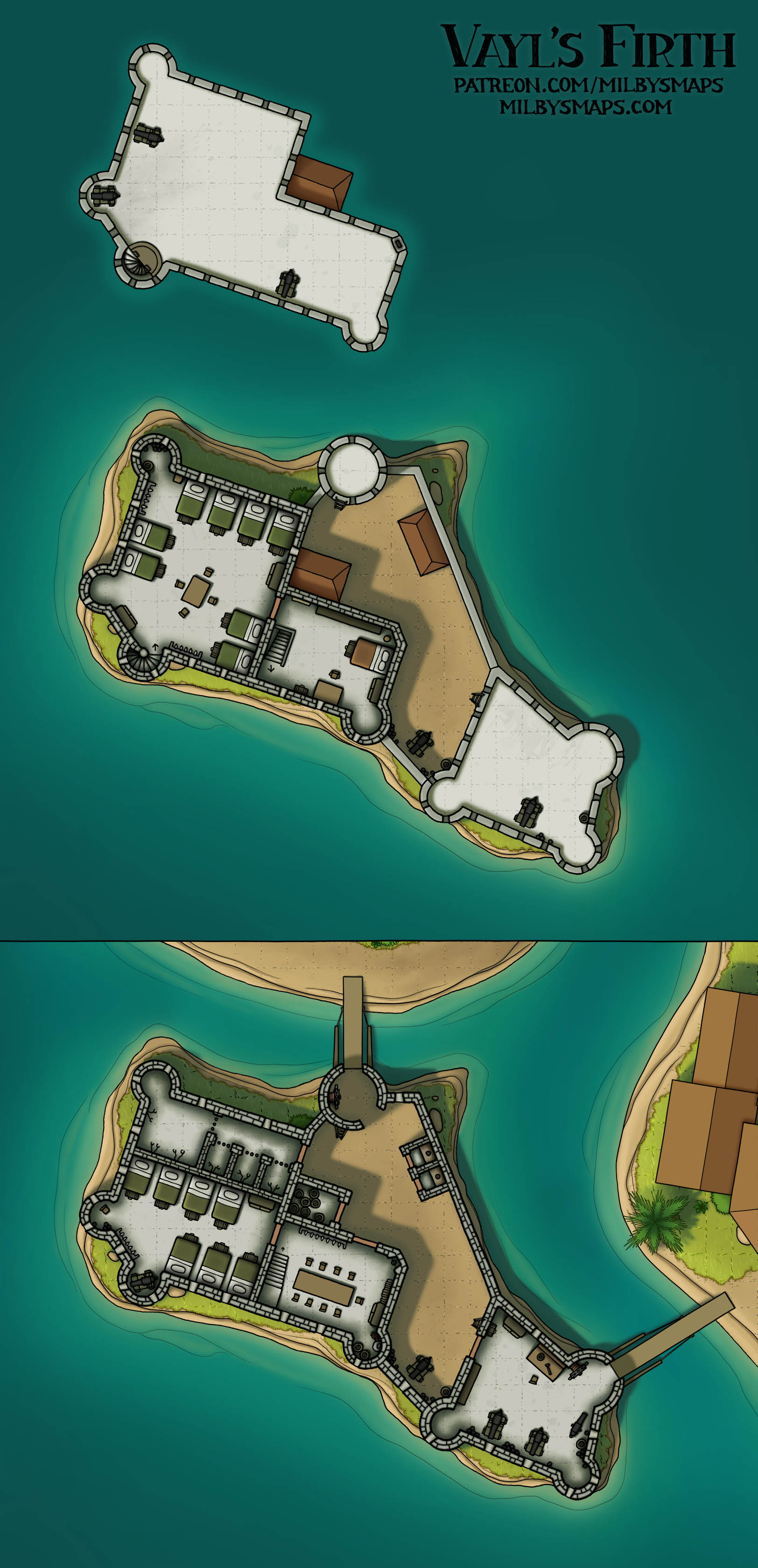
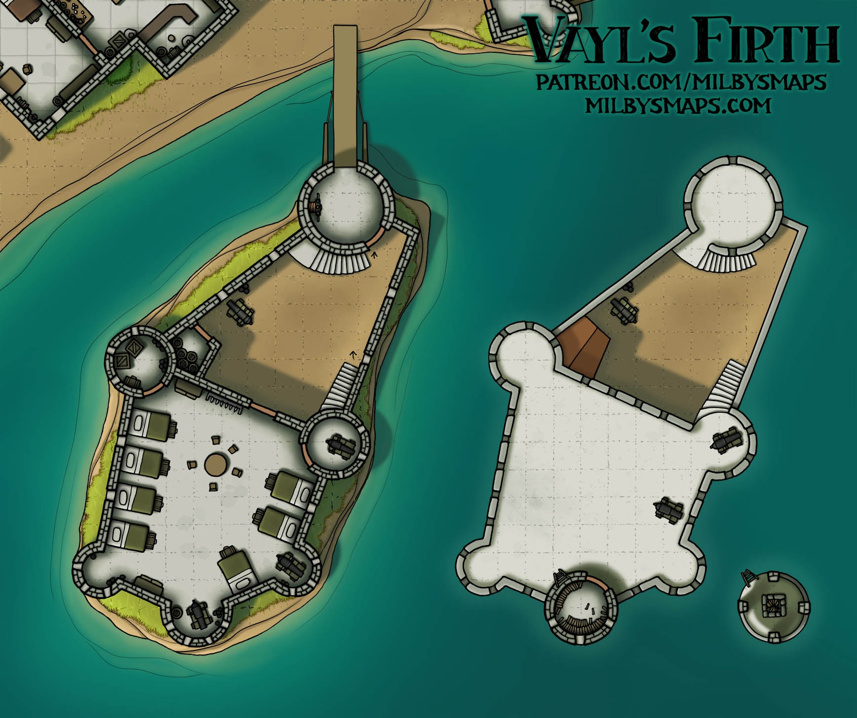
Here’s the finished village of Templemore, built on the ruins of a great, ancient temple. My story about the place is that the temple was dedicated to a long-forgotten goddess of luck. While the residents don’t worship her (or even know who she is), she bestows her blessing of good fortune upon them nonetheless. So if the players show up at the tavern and start gambling with the old fellas at the corner table, things are likely to go very poorly for them.

There are variations of that story that could be fun, too. If you change the goddess and the blessing, there are a lot of potentially interesting scenarios that could become the seed for an adventure. Like, what if it’s the goddess of time and she stops the residents from aging. Or what if it’s the goddess of death and everyone rises from the dead after they die. Or what if the goddess is angry that they’re here and curses them instead. There are a lot of ways you could go with it if you want to get creative.

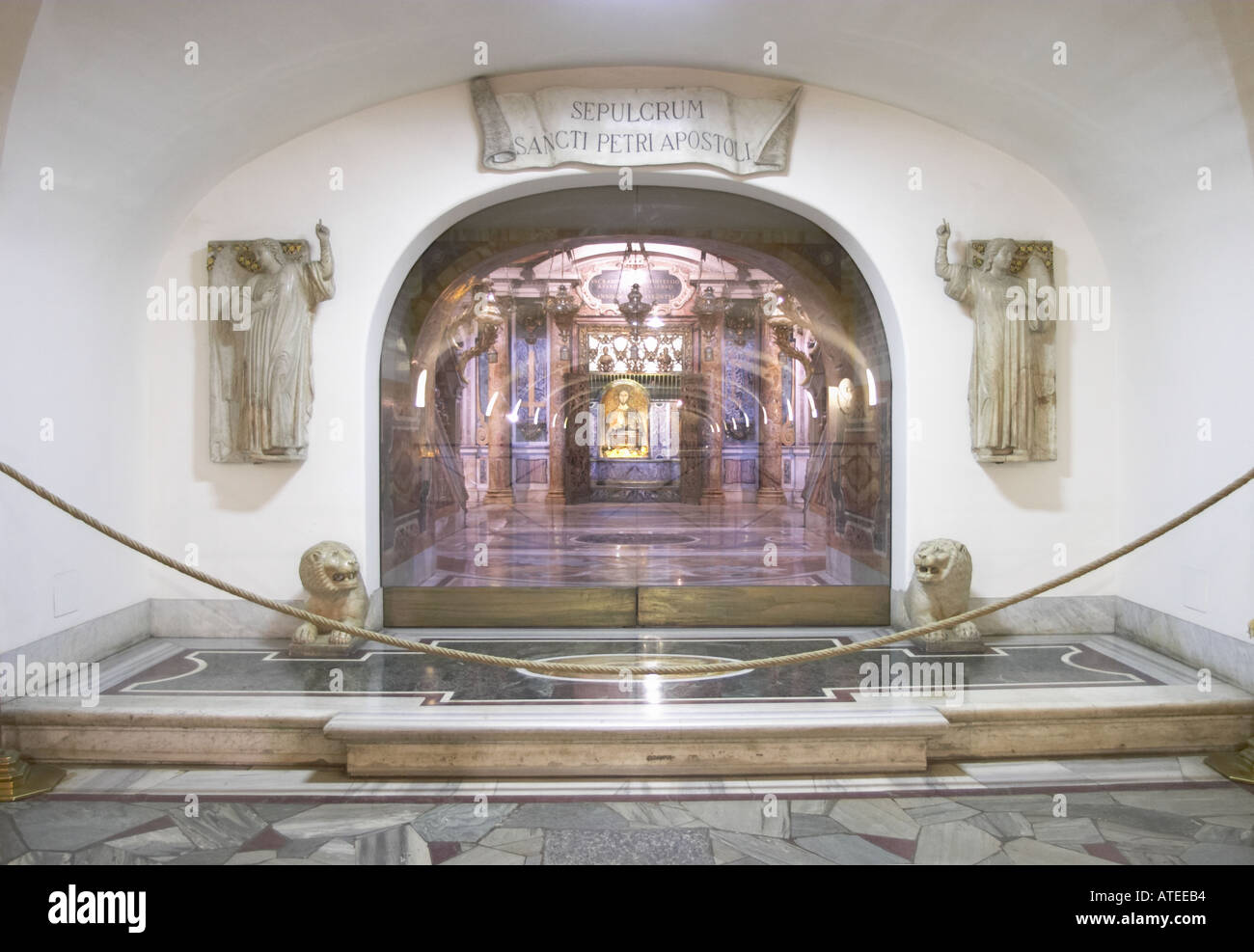
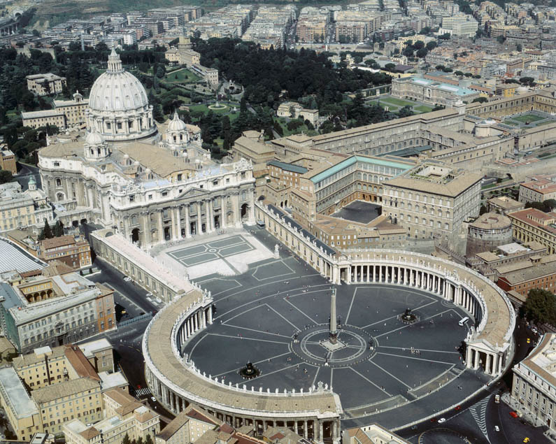
Next up, I’ll be drawing the Vatican Grottoes underneath St. Peter’s Basilica. These are a series of tunnels, chapels and tombs, including the tomb of St. Peter himself. This won’t take nearly as long as the main floor of the Basilica itself, but, as you can see in this picture, they went pretty hard on both the floors and the statuary, so it’ll take a bit longer than it would have if the Vatican had hired a cheaper contractor. Also, I want to add that I love statues of animals by sculptors who’ve never seen that animal in real life and the lions in that picture are a great example.

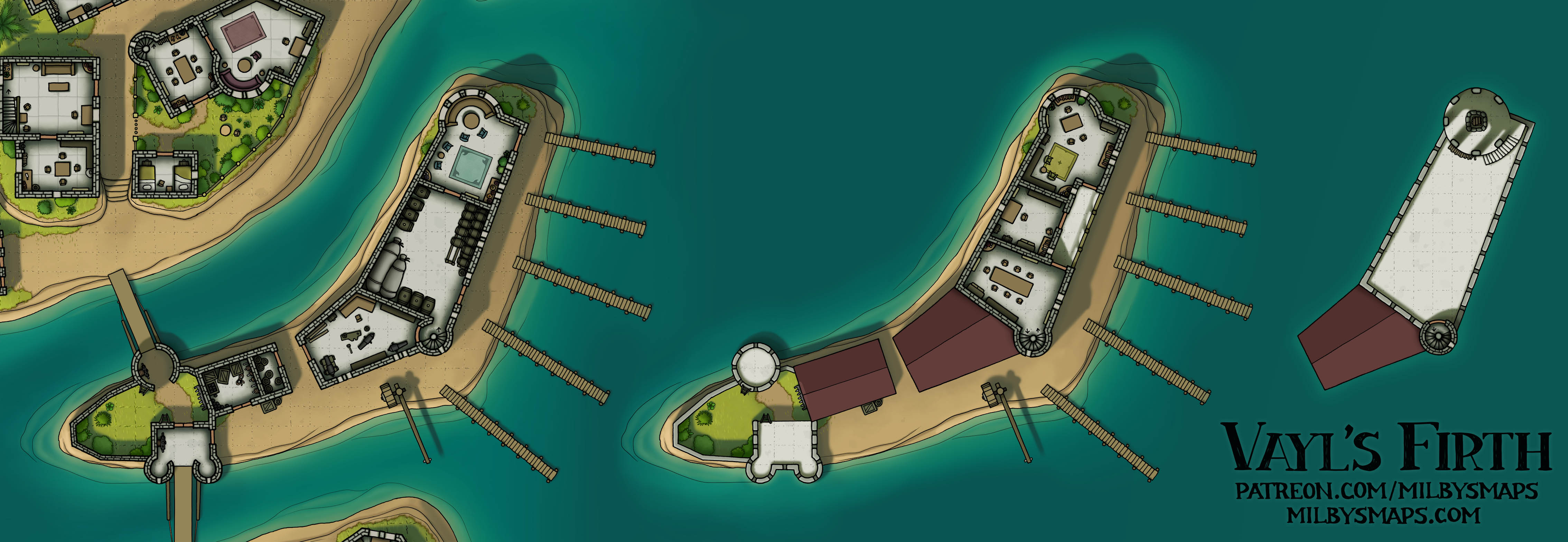
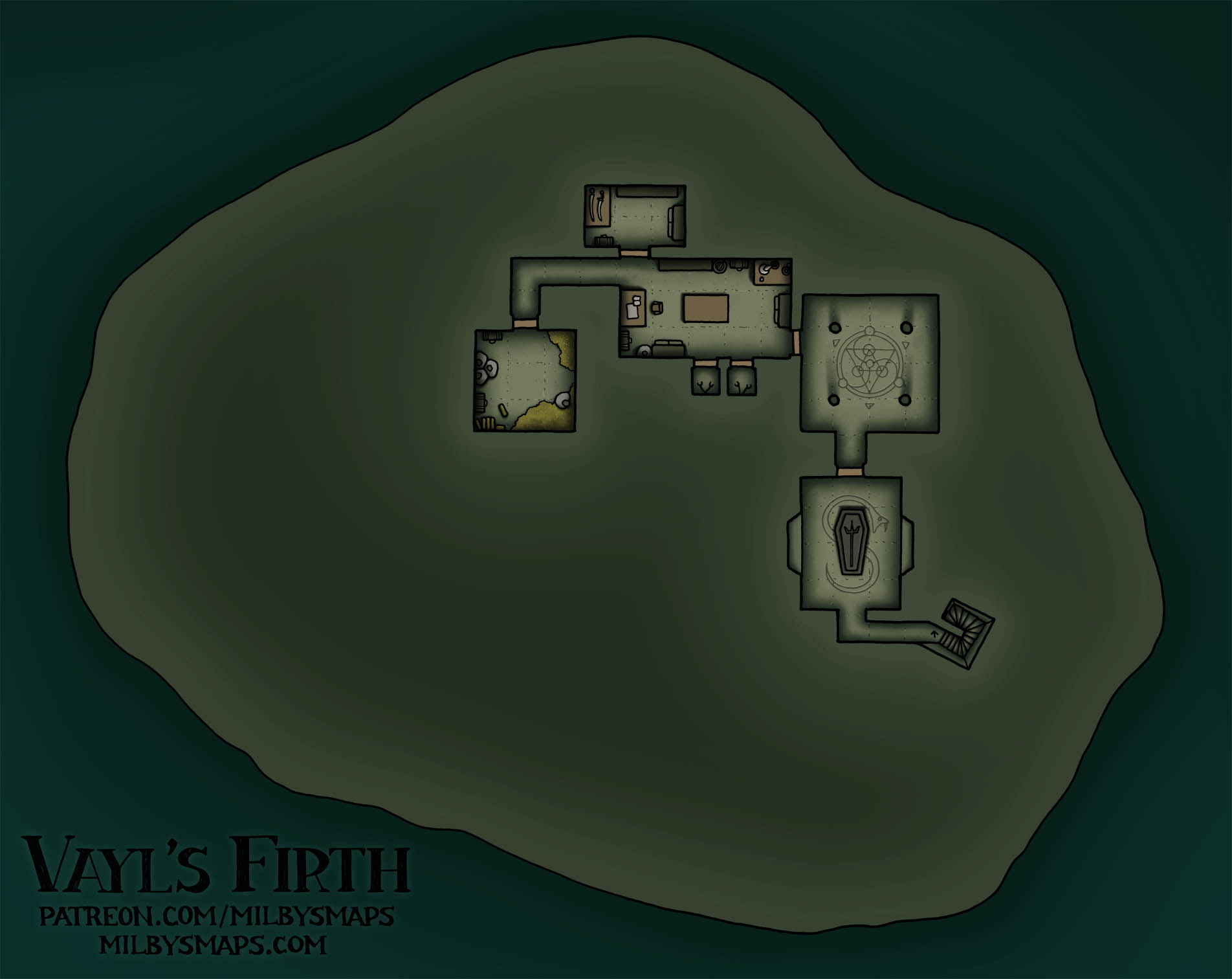
Anyway, I think that’s about it. I hope you like the map. Let me know what you think!

St. Peter’s Basilica: Roof Level

Here’s another part of St. Peter’s Basilica finished. We’ve still got the grottoes and the Roman necropolis left to draw. And, of course, the rest of Vatican City. For reasons I explained here, I’ll be drawing in the backgrounds and surrounding buildings later. In the meantime, I hope the lack of surroundings doesn’t impede anyone’s ability to run adventures in the land of Catholicism.

By the way, I’m not planning to draw the roof levels of every building in the Vatican. I decided to draw this one because:

  1. There are numerous stairs to the roof.
  2. It’s a cool roof.
  3. The basilica is kind of the centerpiece of the Vatican.

But, like, I don’t think we need a map for the roof of the Pontifical Academy of Sciences. If there’s another roof that’s worth drawing, I’ll draw it, but I’ll probably skip it for most places.

Next, I’ll be drawing last month’s Cartographic Congress winner, which is a medieval village built in the ruins of an ancient megastructure. I haven’t decided on the megastructure that the village is built on just yet, but it could be an ancient temple, a huge amphitheater or something like that. If you’ve got any ideas, let me know.

Anyway, that’s it for now. Let me know what you think!

The Town of Chalymn

Chalymn is a small chunk of a city on the world’s surface that rose up into the sky to avoid a coming disaster. The large citadel in the center belongs to Magister Viskand, the powerful mage who ripped Chalymn loose from the earth. It’s not entirely clear if the magister saved everyone else on the rock intentionally, or if he just wanted to bring a little more land with him, but, look, they’re alive and that’s what matters.

If Chalymn demonstrates one thing, it’s that a little, floating rock in the sky can have anything that they have on the surface. The surface has lakes? Chalymn has a lake. The surface has a complex network of tunnels and cities deep underground? Well, Chalymn has one of those, too. It could be a very interesting place to visit if your party happens to get a ride on an airship at some point. Or a spelljammer.

Speaking of which, I’m going to make a spelljammer version of the map with a space background for patrons, which I should have done by tomorrow.

Well, this is the second, or maybe third city map I’ve drawn that I don’t think is garbage, but I’m curious to hear what you think. How’d I do? If you’ve got any thoughts or suggestions, let me know!

Floating City (Work-in-Progress)

Here are the drawings for the floating island city. As you can see from the sideview, there’s an underground level as well, which will be in the finished map. It’ll be like a tiny, flying underdark. A sort of “overdark,” if you will.

Anyway, I’m gonna start coloring this thing. Let me know what you think so far!

Mesa Roja

This map is largely based on the Cliff Palace at Mesa Verde, but I made enough changes that I didn’t want to call it Mesa Verde, since that sort of presents it as being an accurate representation. So instead of Green Mesa, I went with Red Mesa.

This place was built around 1200 AD and was only lived in for 100 years before it was abandoned. No one is sure why the people left, but the thing I’m curious about is why no one else moved in. I mean, if me and my friends lived in tents and we stumbled across a bunch of unoccupied stone houses, I’d definitely be moving in. It is a FREE TOWN. Who says no to that? Of course, I’m sure they had their reasons. Maybe the river dried up. Maybe the vibes were off. Or maybe the area had spotty internet. We’ll probably never know.

I need to catch up on drawing Cartographic Congress maps, so next I’ll be drawing a fortified abbey that’s the base of a Templar-style military order. It’ll be any paladin’s dream home, featuring a chapel, statues of stern-looking dudes holding swords, and private rooms for self-flagellation. It’s the perfect place to read the holy scriptures, practice your swordsmanship and feel an overwhelming sense of guilt for that impure thought you had four years ago.

All right, that’s about it. Let me know what you think!

Vatican City – St. Peter’s Square

So the first part of the Vatican City megaproject is done. Well, kind of. One of the tricky things about drawing the Vatican is that there are parts of it I haven’t drawn yet in the background. In the top left is the Apostolic Palace and, at the bottom left, there’s a church called Santa Maria della Pieta. That stuff on the right is Italy. So I’ll have to remake this map with all the other stuff included once it’s done.

Also, St. Peter’s Square is huge. Like, this is actually one of the biggest maps I’ve ever made. That’s 199×160 tiles right there. You can fit multiple football fields inside it (either kind). The pope has a pretty big front yard.

The next part of the Vatican I’m going to draw will probably be St. Peter’s Basilica, the entrance to which is on the left. And I’m not gonna lie, I’m a little apprehensive about that. Because, you see, the floor of the basilica looks like this. Am I going to draw all that? Yes. Is it going to look really cool? Probably. Am I looking forward to it? No, I really am not. I’ll be honest with you: I’m a little scared. But it’s gotta be done and I’m going to do it regardless.

But first, I’ll be drawing last month’s Cartographic Congress winner: a dwarven fort built around a waterfall. There’ll be a lock for boats, a waterwheel or two, stuff like that. And after that, we’re back to the Vatican. Sound good? I hope so.

Anyway, if you’ve got any thoughts or questions, let me know!

Lyndorne Falls

In the seven years that I’ve been making maps for a living, I’ve drawn exactly six city maps. When I say a “city map,” I mean not a battlemap. So stuff like Vayl’s Firth doesn’t count. Here’s the list, from oldest to newest, along with my opinions on them:

  1. Irredeemable garbage
  2. Crap, but crap with a few merits. The lore may have saved it.
  3. Somehow, I think this is worse than the previous one.
  4. This one might have been okay if I hadn’t decided to color the buildings pink for some reason.
  5. This map is what Rogue One is to Star Wars sequels. Not incredible, but much better than all the other garbage.
  6. This map. I think it might be kind of good. I don’t know how or why this happened.

The basic idea for this place is that Lyndorne Falls is a unique kind of trade city. Goods come in on riverboats at the top of the waterfall and they’re moved down to the bottom on cargo lifts, where they get sold on to seafaring traders. Enabling goods from upriver to reach the sea makes this place a big deal, especially if there are a lot of towns out there. Also, the cliffs and the surrounding jungle serve as natural walls to protect the city. On the whole, I’d say it’s a fairly unique town that wouldn’t be hard to find a place for in most settings.

Next, I’m gonna get started on the Vatican megaproject. I’ll be drawing this one piece at a time and I’ll alternate between Vatican maps and other maps, but I’ll start with the famous stuff. First, I’ll be drawing St. Peter’s Square, which looks like this. It’s not the most interesting part of Vatican City, but it is the biggest and it should help me to calibrate the size properly so that all the pieces fit together in the end.

All right, I’m gonna go transubstantiate some paper into a map. Our journey begins.

Sarissa Square Market

Sarissa Square is an arcade market with a variety of shops, vendor stalls and a tavern. It’s a place where your players can have a drink, get pickpocketed, browse a few shops and steal, like, 1gp worth of rope or something despite the fact that they drag a giant wagon full of cash around wherever they go.

Some of you may be asking, “Is this a mall?” Well, it isn’t not a mall. But it’s less of a mall than another map I drew and that one was based on a real design that was almost constructed in Venice in the 1500s. Also, there’s a place called the Chester Rows in Cheshire, England, which is pretty much just a shopping mall that dates back to the middle ages. So, look, if Middle Ages Italy and England can have malls, Waterdeep can have a mall. Or, excuse me, an “arcade market.”

By the way, this was inspired by Pike Place Market in Seattle. The part of it the map is based on is fairly new, so I had to medieval the hell out of it, but I think I got the basic design of the place in there. Also, they do have a bar in there, so the tavern is accurate.

Next up, I’ll be drawing an orcish fortress that walls off a mountain pass. I’ve actually been meaning to draw a fortress in a mountain pass for years now and I can’t believe I actually haven’t drawn one yet. That madness is about to end. After that, I’ve got one or two more maps to draw and then we can get started on the next megaproject: a complete map of the Vatican. Because screw it, let’s draw a whole country. Are you in? I hope so, because this is happening.

I’m back! Vayl’s Firth is Finished!


You can download all these maps here.

It’s been over a month since I posted for non-patrons, but, as promised, here’s the complete city map and the upper levels.

If you want to become a patron, there are individual maps of all the islands, plus unfurnished versions, annotated maps, DM notes, a Foundry module and various other stuff. There’s a lot. It took me three hours to upload all the patrons’ edition maps. Admittedly, I’m on a trash-tier internet connection at the moment, but still.

For anyone who can’t afford that, every part of the map is here for you to use and I hope you enjoy it.

With Vayl’s Firth finished, I’m going to get caught up on all the Cartographic Congress maps that have been chosen since I started drawing this. And then, at some point, I’ll get to work on the next megaproject: The Vatican.

Well, that’s about it. So, what do you think of Vayl’s Firth? I hope it lived up to your expectations. In any case, let me know what you think!

Vayl’s Firth – The Trade Port, Fishing Port and Small Market

Here’s are the first three islands of Vayl’s Firth finished. I’ll have another three up in a few days. Since the map is already about half-colored, they should be coming at a pretty good pace. Most of these smaller sections of the map will be for patrons, but I WILL post the full-size map for everyone once it’s finished.

Next, I’ll be drawing the three islands below these: the poor district, the barracks and the temple. After that, I’ll probably just work my way around the map, finishing each section in turn.

I know I’ve gone over my estimated 2 months to finish this project, but it’s officially delivering maps now and it’ll keep doing so every few days until everything is done. Despite going into overtime, I hope you consider it time well spent.

Well, I’ve got some chairs and crates to color, so I’d better get back to work. If you’ve got any thoughts or questions about the map, by all means let me know!