Thornhall

Thornhall is the palace of a lord of the wilds. A fey king, a high druid, a wood elf prince, or maybe even a hag could live here. The walls and roof are made of tangled roots and vines, twisting around each other in a giant mass of vegetation. It’s a lovely place to live for anyone who doesn’t mind a leaky roof and a slight mold problem.

Next, I’ll be getting to work on the alternate bottom levels of the Stygian City. These maps will be for patrons and will include:

  • A sealed vault meant to hold an entity or artifact
  • A passage to the underdark
  • Nothing but trash and debris
  • An underwater aboleth lair

With the exception of the aboleth lair, these shouldn’t be too complicated. I’ll draw the first three next, then the aboleth lair later. That one might actually be two separate levels, so it’ll take a bit more time. Once that’s out of the way, I’ll be looking to get started on the next megaproject.

Well, that’s it for now. Let me know what you think of the map!

The Ruins of Giltwater

Giltwater is the first Dhasran gold mining colony in Tir Thelandira, marked as “Burned Colony” on this map.

When I finished drawing this, I read back through the lore of Tir Thelandira and realized I’d made a mistake. In the lore, I said that hundreds were killed when the elves attacked Giltwater. But I hadn’t drawn a colony big enough to hold hundreds of people. So what did I do? I did what anyone writing fantasy roleplaying game lore would do. I retconned it. I retconned the absolute living hell out of it.

I think the lore will have to stay a little flexible until the island is done, particularly since there are three locations that haven’t been decided on yet, which makes them hard to plan for. Speaking of which, if you’re a patron and you haven’t cast a vote on the second ballot for location #1, you’ve got one more day to do that.

So, what’s next? Well, I’m sick at the moment and I don’t have it in me to start on a new map today, so I’m going to give myself something easy to do. Tir Thelandira is going to be part of a larger world with many more islands and I want to start laying out that larger world so we can start thinking about where we go once this first island is done. I feel like I’m up to that. I can draw a collection of variously-sized blobs. I believe in me.

I should have that done tomorrow and you can tell me your thoughts about it. After that, I’ll get started on another map for Tir Thelandira. Okay. Time for blobs.

Frog’s Haven Crannog

In the last post, I talked about my plans for the first island of the as-yet-unnamed big project. There will be two civilizations living on the island, one of which will be a kingdom of wild elves.

Over the past century, the wild elves have been shifting from a tribal, nomadic society to a settled one. While the elves have become better at building large structures of timber and stone, their skills at architecture are still well behind those of other civilizations. To reflect this, many of the wild elves’ settlements will be inspired by Iron Age Celtic buildings from Ireland and Scotland. Here’s a breakdown of what I have in mind:

Crannog – A crannog is a man-made island with one or more houses on it. The island was often surrounded by a wooden palisade and had either a narrow causeway or a path of stepping stones leading to the shore. Crannogs were most common in Ireland and Scotland. Frog’s Haven will probably be the only one.

Broch – A broch is an old style of Scottish towerhouse, which looks like this. I think I’d draw this fairly similar to the one pictured, perhaps with some farmland around the walls. I’d also give it a slightly more elven, tribal look.

Motte and Bailey (or something similar) – A motte and bailey is an old style of wooden castle, which looks like this. I’d probably use a more elaborate version of the design and I’d make it more of a walled village rather than a fort. Again, it’d have an elven style to it as well.

OakenholdThis is one of the first maps I ever posted. I’ve never redrawn a map, but I want to redraw this one and I want it to be the seat of power for this wild elven civilization. I’ll change plenty about it, but it’ll be the same basic design. This is where the king or queen lives.

That’s the plan so far. There will probably be other locations as well, but I want to get your opinions on these ideas first. If the response is largely negative, I’ll come up with something else. If it’s positive, I’ll get started on a map of the island and we can start figuring out where things are and who the elves are sharing the island with.

Anyway, let me know what you think of the Celtic wild elves. Positive or negative, I really want to hear your opinions!

Fort Bourtange – Roof Level and Dutch Version

Here’s the roof level, which is the last part of Fort Bourtange. I also made something else: an annotated version in Dutch, which I’m giving out to everyone.

I’m aware that everyone in the Netherlands under the age of 105 speaks perfect English along with 50 other languages, so I know you probably don’t need this, but I still thought it’d be nice to do. Plus, the English version comes from a Dutch tour map I translated, so I figured I could just not translate it and make a Dutch version that way. There are a couple things I had to use Google for, so I can’t promise it’s perfect, but let me know if anything is wrong or just super weird and I’ll fix it.

Anyway, the next map will be a demonologist’s lair, Remember A Dark Place? I’m gonna try to make someplace freakier than that. It’s not Hell, but it’s the home of… well, a big fan of Hell. A Hell stan, if you will. Hopefully I can come up with something uniquely terrible.

I’ve also got the next historical map picked out, which I’ll be doing sometime in the next few 2-3 months. This time, I’ll be drawing a place in Britain– or, more specifically, Scotland. There are some incredible places in Scotland, like Stirling Castle, the Wallace Monument, and about half the buildings in Edinburgh. Instead of drawing any of that stuff, I’m going to draw Coxton Tower. It’s a towerhouse in Moray and I think it’d make a great map. It’s not huge, complicated or flashy, but it’s interesting. It’s got some unique character, both inside and outside, and it’s the kind of place everyone can find a use for.

I don’t know exactly when I’ll start on it, but I definitely want to put some work in on the Black Loch first. That’s Scottish, too. Well, a little. I mean, it’s not the Black Lake. Anyway, I’m gonna go sketch out some freaky demon stuff. If you’ve got any thoughts on any of this, let me know!

Fort Bourtange

In the 1500s, the Netherlands were ruled by the Habsburgs. The Habsburgs were an astoundingly inbred German noble family with faces that were about 85% chin. For some reason, they were the rulers of the Spanish Empire.

The people of the the Low Countries didn’t want to be ruled by German people, Spanish people or inbred people, let alone a combination of the three. They wanted self-determination, a republic and the right to worship the protestant version of God. So, in the mid-1500s, the Dutch Revolt began.

The Spanish Empire ruled Spain, part of Italy, Austria, and– you know the countries that speak Spanish today? All of those. It was a daunting enemy, but the Low Countries had one thing going for them: stupefying amounts of money. And they planned to leverage that to win.

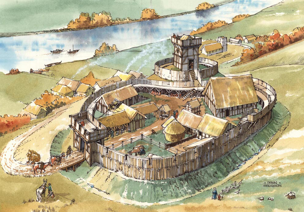
One of the things the Dutch spent that money on was Fort Bourtange. Since the Spanish were allied with the Holy Roman Empire, they’d need a way to protect the Dutch land from the Deutschland. One of the main roads to Germany passed through a marsh, so the leader of the revolt, Willem van Oranje, ordered the construction of a fort across it.

Building a star fort with forty buildings, a crownwork, four ravelins and two moats is an expensive operation. But not only did they build it, they built it on a sandbar in the middle of a marsh.

Fort Bourtange was such an obvious deathtrap that not many people were inclined to order their armies to assault it. But, about 100 years after its construction, Bernhard von Galen, the Prince-Bishop of Münster, came along to give it the old college try. During a parley before the attack, he told the fort’s commander, Captain Protts, he had 200,000 guilders for him if he’d surrender Bourtange. Protts famously responded by telling von Galen he had 200,000 bullets for him and his men. Von Galen decided to send his soldiers to go receive them, which resulted in a crushing defeat for his army. He then went on to besiege the nearby city of Groningen, which he also failed at.

In later years, the fort began to transition into a village, where the soldiers of the garrison lived with their families. Then, in the 1800s, the fort was turned into a village for local farmers.

Well, this map was a ton of work, but I hope you like it! I’m going to make a roof-level version of the fort next, which should only take a couple days, then I’ll be moving on to the next map. I plan to make a big push on getting some Black Loch maps done over the next few months as well.

Anyway, let me know what you think of Fort Bourtange!

There’s an annotated version of this map and DM notes available to patrons.

The Seer’s Home


I recently started a Patreon and I decided that I’d offer to make a map of my first patron’s choice.  She requested a swamp map with the home of a wise woman, the entrance to which is hidden in a tree.

To make it interesting, I threw in some huts that could be used for some sort of encounter.  They could be a community of lizardmen, bullywugs or just good old fashioned hillbillies.  After that, we’ve got some ruins, which could contain another encounter or just be used as cover in a fight.

The wise woman’s home in the bottom right leads from the staircase in the giant tree stump.  I didn’t think that needed an explanation on the map, but if anyone found it unclear, please let me know.

Anyway, I hope you like it, LadyAhiru!

Here’s a couple alternate versions of the map: