Tortuga – Overview and DM Notes

Here’s the final map of Tortuga: the overview.  The image above is the gridless version because I think it looks better.  I’m not sure why.  Here’s the gridded map.

Also, I’m giving away the DM notes on this one because they explain some important things about this map, as well as my thoughts on the ways it can be used in a campaign (especially as a traveling home city for PCs).  Here they are:

So, now that the six-story turtle town is out of the way, it’s time to start on something much, much bigger: Brazenthrone.  I’ll have a map of the layout of the city up on Monday.

The Town of Tortuga Upon the Great Zaratan Monhatnus – Main Deck


First off:  “What is a zaratan?”

A zaratan is a giant turtle that sleeps for years at a time.  They often come to look like islands, with plants and even trees growing from their backs.  Sometimes, people– knowingly or unknowingly– inhabit those “islands.”  The main problem with living on a zaratan is this: when they get hungry, they wake up and look for food.  And when they look for food, they dive.  Which is catastrophic for anyone living on the creature’s back.  So, in order to prevent this, the zaratan must be fed.  Even sleeping, it will eat anything coming into its mouth.  The town of Tortuga is well-prepared to handle this, having a small fleet of fishing boats and a large crane to deliver their offerings.

The idea for this map came from a patron, who suggested a city on a zaratan.  That’s been done before, of course, but it’s typically a small village with a few huts.  I thought it’d be interesting to make the most overpopulated zaratan ever.

My idea was that the town of Tortuga grew so much that they had to keep building higher and higher, which necessitated constructing the wooden deck on their host’s back.  After all, it’s hard to build a solid foundation on a curved surface, especially when you can’t dig or drill down into it without pissing off a creature that can bite the head off a storm giant.

Here’s a (mostly) gridless version, a black and white version, a version without annotations and a gridless version without annotations.

Since this map is so complicated, I’m releasing this partially annotated edition to all, but there is a fully annotated Patrons’ Edition with around 45 rooms marked available on the patreon.

Finbarr’s Marsh – The Crypts – IT’S FINISHED!!!!!!!!!!!!!!


Black and white version

This has been one hell of a long project, but it’s finally done!  And as much as I loved making it, I am really looking forward to drawing something else.

So, here’s the final tally:  Finbarr’s Marsh has 135 buildings with 703 rooms across 10 different floors (7 above ground and 3 below).  It took almost a month to draw (I’d say around 200 hours) on 14 sheets of A3/Tabloid paper (equivalent to 28 normal-sized sheets of paper).  Here’s a photo of the whole thing on paper, by the way.

Also, I’ve put up a goal on my Patreon.  Here it is:

When I reach 50 patrons, I will start work on another megaproject. This will be a map of an underground dwarven city. It will include a surface settlement, a gateway into the mountain, fortified tunnels, a huge central ward (itself almost the size of Finbarr’s Marsh) and four Quarters– the Common Quarter, the Noble Quarter, the Anvil Quarter and the Old Quarter. These will each be around half the size of Finbarr’s. In addition, there will be maps of the mines, the mushroom farms, the High King’s palace, the prison, the Grand Temple, residential areas, the treasure vaults, the gnomes’ district, an underdark trading outpost, adjacent ruins, and more. It will be usable as either an inhabited city or as a huge abandoned ruin big enough to run entire campaigns in. I want to make something absolutely legendary in size and scope. This is the best idea I have in me. I made Finbarr’s Marsh in part to prove to myself that I can do it. Let’s make it happen.

If and when this goal is reached, I will alternate between drawing maps for this project and other maps.  I cannot tell you that it will be the biggest map you have ever seen, but it will be the biggest map I have ever seen.

Finbarr’s Marsh – The Sewers


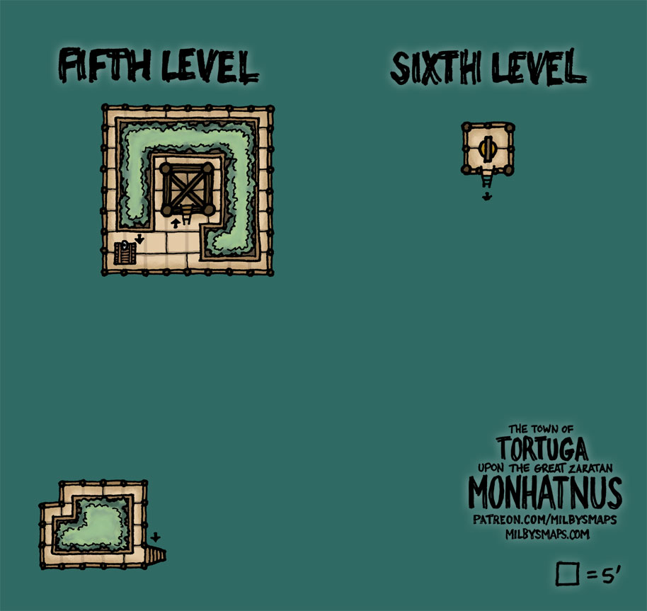
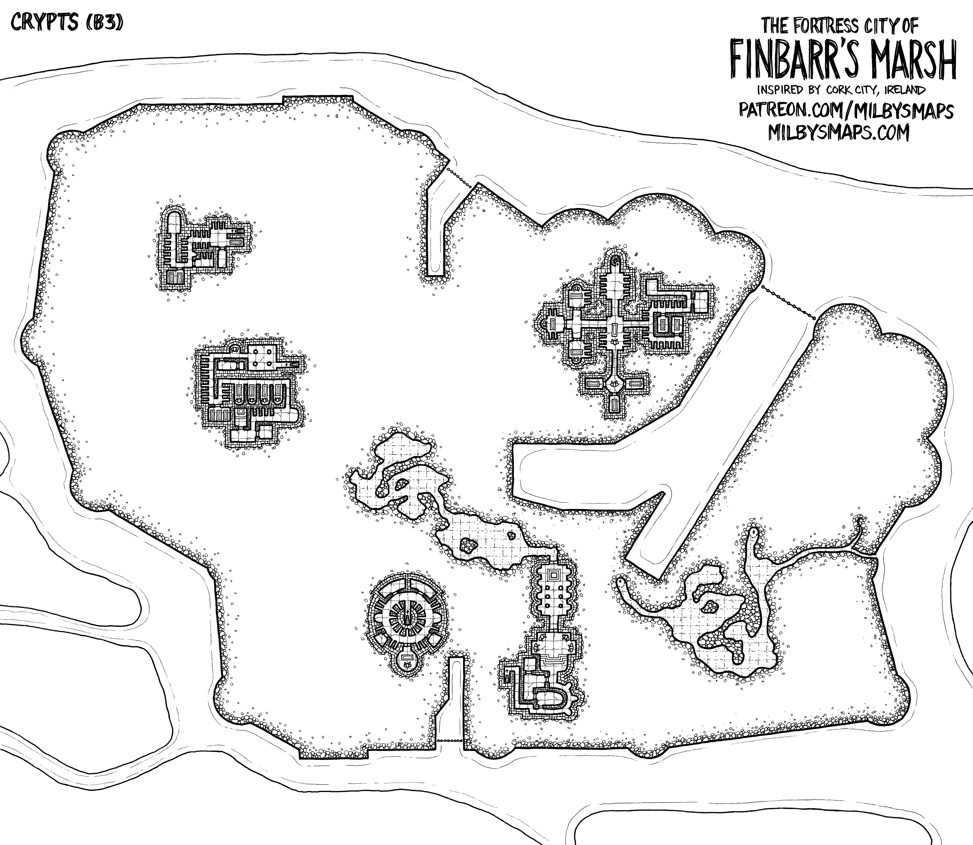
This is the second to last map of Finbarr’s Marsh.  The crypts will be up in a few days.

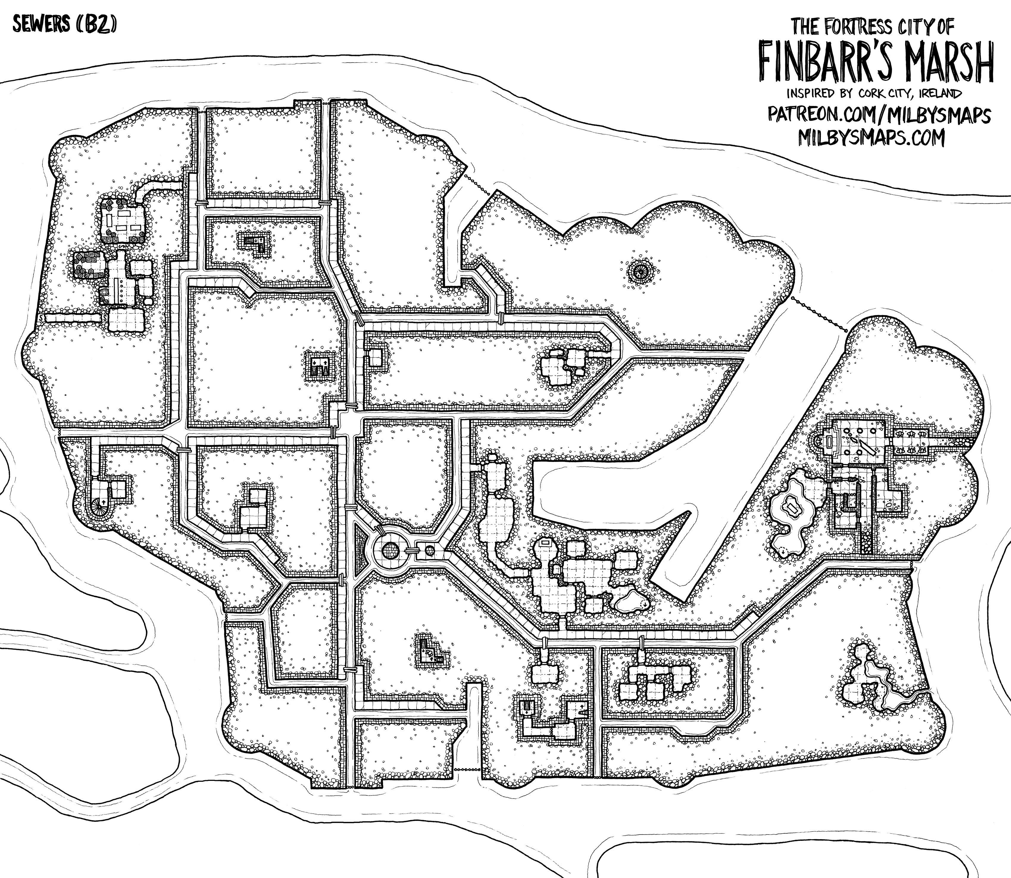
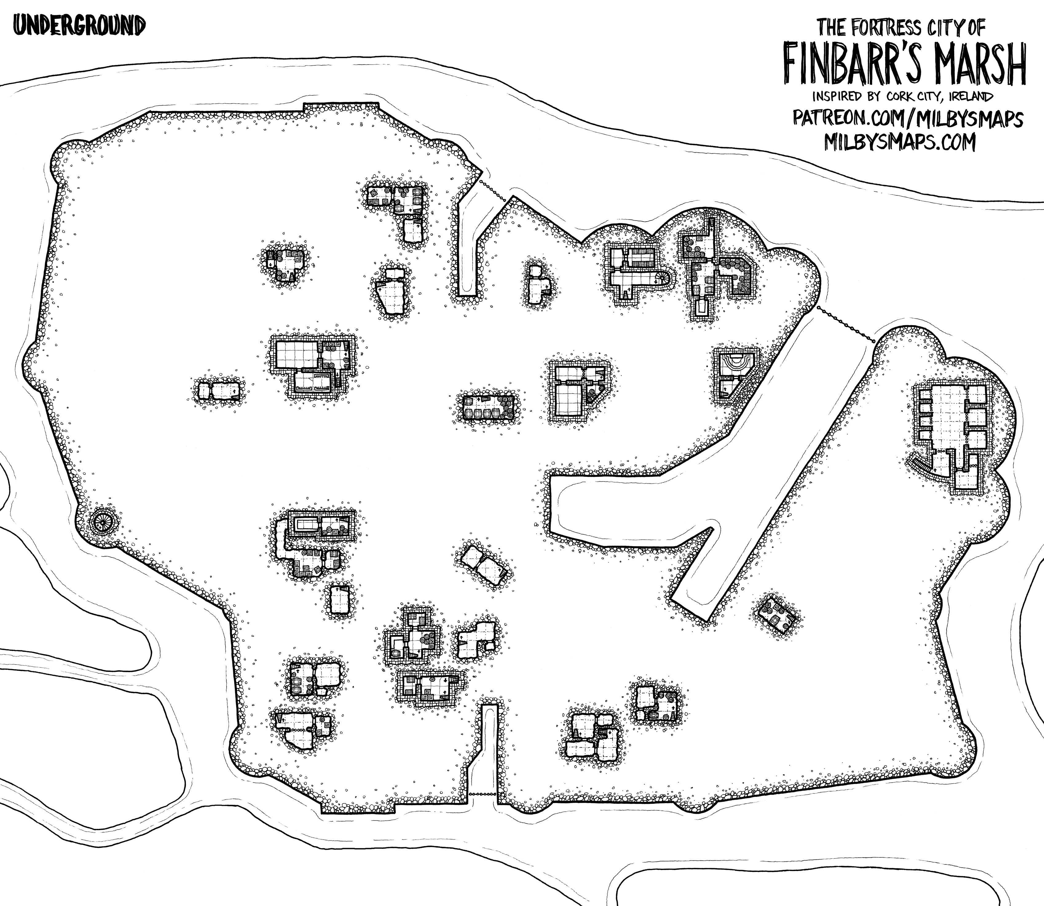
So let’s talk about the sewers.  First, I need to mention elevation.  The underground level is above this, which means it’s fully above the water level.  Why?  The island has steep sides and the ground level is about 15 feet above the water.  With that out of the way, let’s talk about the locations.

The kuo-toan temple on the left predates the city and was in ruins by the time the first settlers showed up.  The passages into it were eventually blocked off with stone because, well, no one wants an open passage leading right under their castle.

The Drainers are human.  They’re poor and live in the sewers, subsisting on mushrooms and selling their excess fertilizer to farmers in the area.  They smell.  But everything down here smells, so it’s fine.  The authorities know about them and have told them they can stay.  But no more digging.

The Theives’ Guild’s bread and butter, unusually, isn’t theiving, but dealing in smuggled goods.  They have an arrangement with some fishermen to bring goods in from cargo ships, a few crates at a time, evading the customs tariffs and any laws concerning contraband.  They buy the goods from the fishermen, then sell them around the city at a tidy profit.  They’re secretly working with one of the wealthy trading houses as well (the De Barras).  They do also steal stuff.  Sometimes.

The sea trolls (scrags) aren’t a huge priority for the city guard, although they can be troublesome.  And the entrance to their lair is small and completely underwater, which would make dealing with them an enormous pain.

The Witch of the Pipes is whoever you want her to be.

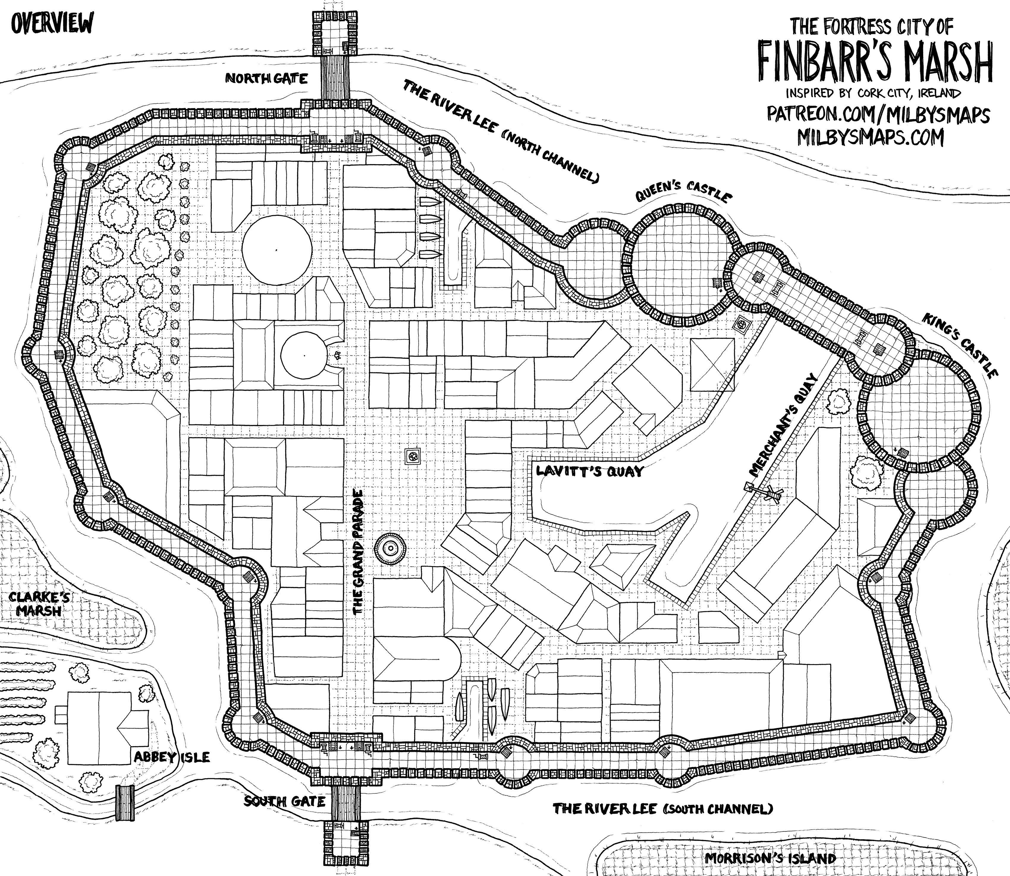
Here’s a version without annotations and a black and white line art version.

Finbarr’s Marsh – Underground


There’s not a ton going on in this level of the city, but, I mean, how much is going on in your basement?  We’ve got a few points of interest: the Royal Treasury, a dungeon, a strange magical gateway in the Tower of Thaumaturgy and a secret room.

Next up is the level below this:  the sewers.  After that, the crypts.  We’re on the homestretch!

Here’s the black and white version.

There’s an annotated Patrons’ Edition of this map.

Finbarr’s Marsh – Overview Map


This is basically the 7th floor map of Finbarr’s Marsh, showing everything from the highest point (the walkway over the sea gate) on down.  The next map is the basements, then the sewers, and, finally, the crypts.

I’ve got plans for the sewers.  Initially, I was just going to do a mostly utilitarian system of drainage tunnels, but then I just decided to go wild with it and put some crazy stuff down there.  I’ll be releasing a limited annotated version for free like I did with the ground level map.

Anyway, keep checking in, I should have this done in around a week.

The black and white version.