Valley of the Five Mages

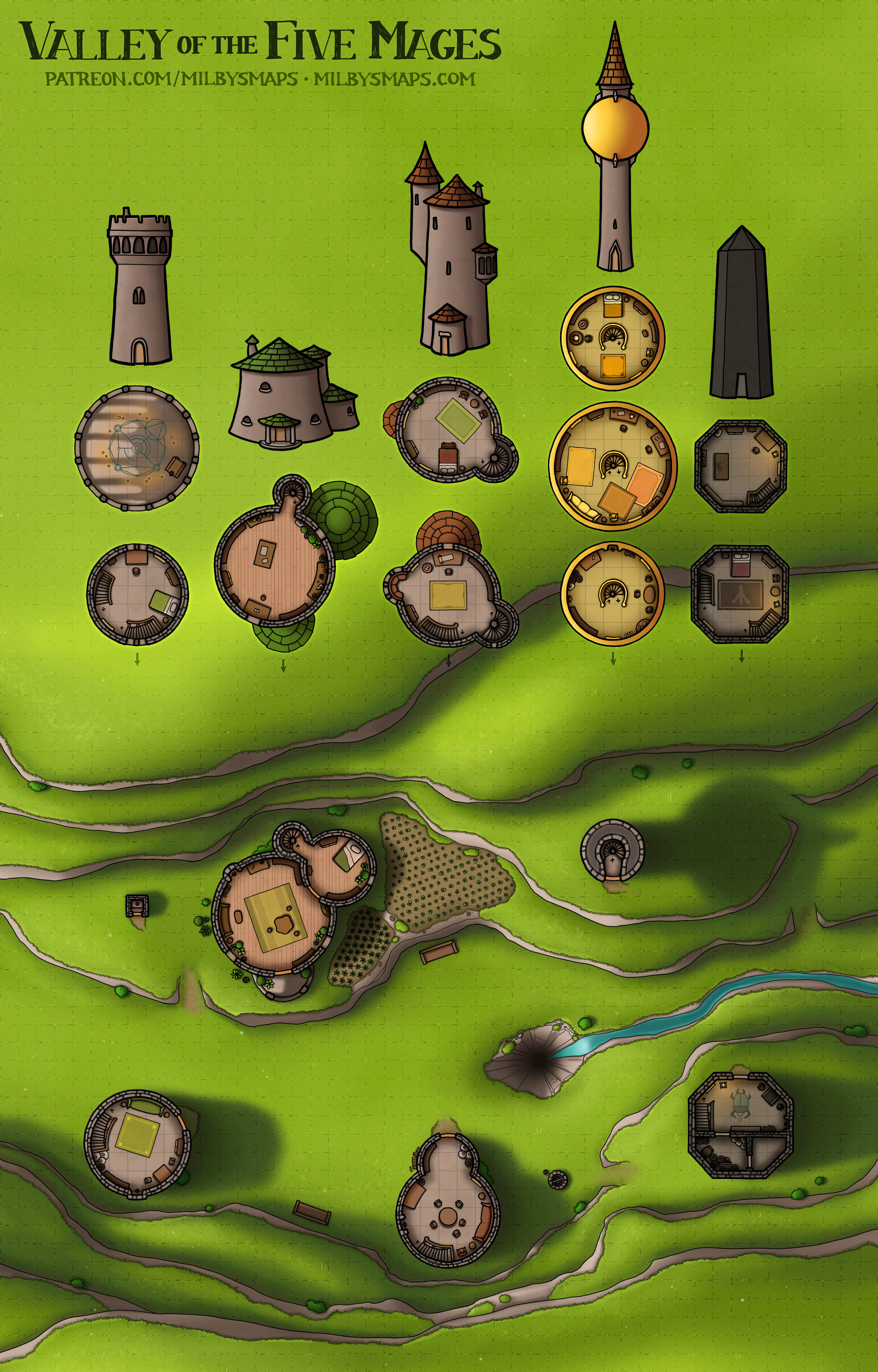
The Valley of the Five Mages is the last map for Tir Thelandira and, while it’s mostly independent from the rest of the lore, I think it’s a nice addition to the island. The basic story is that five mages have come here from far away to study a mysterious hole in the ground that radiates an intense magical energy.

I wrote some thoughts about what might be down there in the DM notes for the map, but the best option is to have the wizards tell the party they believe there’s a powerful, arcane entity living down there. Then, when the players go down to check it out, it turns out to be a 50-foot-tall prairie dog jacked up on potions of growth. They won’t see that coming, I’ll tell you that much.

Next, I’m going to make separate maps of these five towers. Not everyone needs a valley full of towers, but almost everyone does need towers from time to time, so I thought I’d chop this up into single servings. That shouldn’t take more than a day, so they’ll probably be up tomorrow.

After that, I’ve got to finish up a few things for TIr Thelandira, like updating the History and Lore overview and the island map with the new locations, then putting it all together in a Tir Thelandira Codex, similar to what I made for Brazenthrone and the Black Loch. Once Tir Thelandira is officially done, I’ll be starting on the megaproject I’ve been talking about. Here’s the description I posted before:

Imagine a ship, like a galleon or a ship of the line, but much bigger. Bigger than any sailing ship ever built. 400′ (130m) long and 140′ (45m) across the beam. Eight masts, thirty sails. But this isn’t just a ship, it’s a town with hundreds of residents. Across the ship’s 5-6 full decks, there are shops, craftsmen, a marketplace, a tavern, an inn, a temple, gardens, a library, a mill and a lot more. There are cabins for the middle class, luxury apartments for the rich and hammocks for the poor. This is a ship you could get lost in. It could be a community of traders, explorers, pirates or wanderers.

I’ve been looking forward to drawing this for a while now and I think it’s going to be the kind of map you could work into a lot of adventures or even plan an entire campaign around. In any case, I’ve never seen anything like the map I’m imagining and I think it needs to exist, so I’m going to roll up my sleeves and draw it.

Well, I think that’s it for now. I’m gonna finish wrapping up this megaproject so I can get started on the next one. If you’ve got any thoughts, by all means let me know!

The Ruins of the Torre Scola – Dehumidified Version

As promised, here’s the alternate version of the Torre Scola. It’s occurred to me that I draw quite a lot of islands and that I should probably draw non-island versions of those maps as well for those DMs whose campaigns involve ungulate-based travel.

So, the voting has ended and the final map for Tir Thelandira will be a valley of wizards. This will be a small community of 3-5 wizards, each with their own tower. I’ll probably make a map of the whole valley as well as individual maps of the towers for anyone who wants to use them separately.

After that, I’ll get started on the giant ship megaproject that I talked about in this post. I’ve been champing at the bit to start on that for a while now and I’m really looking forward to it. Anyway, that’s it for now. Let me know what you think of the map!

The Ruins of the Torre Scola

The Torre Scola (“Scola Tower”) is a ruined tower off the coast of La Spezia, Italy. Built in the 1600s, it was heavily damaged during the Napoleonic Wars, then later used for target practice by the Italian Navy in the early 1900s.

Personally, I think the historical value of this place should’ve been enough to keep people from pounding it with naval guns. But even if we ignore that– even if we say, “It’s fine, there’s no shortage of old stuff in Italy and it’s not like this is the Colosseum,” there’s still one more important thing to consider: THIS THING IS ONLY 200 METERS OFF THE COAST. So, you know, try not to miss. No pressure.

Anyway, I’m going to make a non-island version of this map as well, which should be done later tonight. So I’ll be back with that in a bit and we’ll talk about what’s next.

The Monastery of Varlaam in Meteora, Greece

Whew, this thing was a ton of work, but it’s finally done! This is a place I’ve wanted to draw for a long time and I was really glad to see someone propose it to the Cartographic Congress and win.

There’s something I didn’t realize about this place until I started working on it, though. I knew there was a mountaintop monastery in Meteora, Greece, but when I started looking for floor plans of the place, it turned out there are six. And there used to be twenty-four.

Imagine something for a moment. It’s the middle ages and you’re Greek. But the big city lifestyle was never for you, so you and a couple other fellas go out to the middle of nowhere, climb to the top of a giant rock formation and start building a monastery. Here, you can devote your life to God, get away from the rest of the world and live in quiet peace. And then some other people show up and start covering every rock in sight with twenty-three other monasteries. I mean, the first few are probably fine, but once they start hitting double digits, you’re probably ready to throw your hands up and move back to Athens.

So, here’s what I’ve got planned: I’m going to make a small map next. It’ll be something to do while I’m waiting for the last Tir Thelandira map to be decided on. If you’re a patron, the runoff vote is now open. After that, I’m going to finish Tir Thelandira and get started on that giant city-ship map I was talking about in this post. That’ll probably take a month or so to finish. It’s absolutely a megaproject and it’ll be bigger than any ship map I’ve ever seen by an order of magnitude or more.

Anyway. that’s what’s in the works. Hope it sounds good! Let me know what you think!

Wait, one last thing: if you’re a patron and you use Foundry, I just started a new Foundry module. Because Patrons’ Module 2 got so big that Foundry couldn’t export it without crashing. Not a joke. Anyway, you can find the link to install Patrons’ Module 3 on this page.

Varlaam Monastery in Meteora, Greece

The monastery of Varlaam sits atop a large rock formation in Meteora, Greece. Look at this place and tell me it’s not absolutely epic. This is something I’ve wanted to draw for a long time and I hope I do it justice. I’ll probably draw a sideview as well, but this is the art for the map itself done.

Well, what do you think so far?

By the way, it looks like the Château de Brézé will be the next historical map. I actually went there last year and took a TON of pictures specifically so I could draw a map of the place later. Castles with complex networks of caves and tunnels underneath them are much more common in D&D maps than in real life, but this place is one exception. Anyway, I think you’re gonna like it.

Ethermont House

Ethermont House is the guildhall of the Imperial Society of Extraordinary Adventurers, who have done pretty well for themselves over the years. As it turns out, breaking into the homes of evil wizards, killing them and selling all their stuff is a fairly profitable line of work.

When the job is done and you’ve finally cleaned all the little chunks of Saruman off your battleaxe, Ethermont is a great place to go and relax with some friends. Then, after a night in the beer hall and the billard room, you can go up to the guildmaster’s office, pick up another contract and head out to smoke Voldemort.

So, I started my patreon 5 years ago this month and it feels like I should do something special. So I’m going to hold a vote for all patrons on which historical map I should draw. The options will be:

  1. Château de Brézé – A French castle with an elaborate network of caves and tunnels dug around and underneath it.

  2. Stack Rock Fort – A British sea fort off the coast of Wales.

  3. Church of St. George, Lalibela – A very unique church carved into the bedrock in Ethiopia.

  4. Castel Sant’Angelo – Hadrian’s Tomb, which later became the pope’s castle.

These are places that have been on my to-do list for a while now and I think they will all make amazing maps. One of the monasteries of Meteora, Greece would have been on the list as well, but it just won last month’s Cartographic Congress vote, so I’m drawing it next. Between that, the giant ship and whatever wins the vote, there’ll be some cool stuff coming up.

I want to say thank you to everyone who’s supported my art over the last five years. Being able to wake up and draw maps for you every day is the best way I can imagine to make a living and I appreciate it more than you will ever know. Thank you all.

Guildhall of the Imperial Society of Extraordinary Adventurers (Work-in-Progress)

This adventurers’ guildhall is a large manor with a courtyard, library, music room, training hall and a gallery of various artifacts acquired (“acquired“) by guild members over the course of their adventures. It could also make a nice base for the party or a good location for a classic armed robbery-themed adventure.

Anyway, I’m gonna get to work on coloring this place. Let me know what you think!

The Hall of the Bearded Men

This is the ancient ruin found on Tir Thelandira. The wood elves who inhabit the island don’t know who built it or why, only that it was here before they were. The “Bearded Men,” as the elves call them, are a great mystery. They certainly weren’t elves and they don’t look like humans, either. A few claim to have seen a Bearded Man who arrived on a ship centuries ago, but few believe them. Perhaps, one day, another Bearded Man will arrive, if any still exist.

This map is the ancient, mysterious ruin that patrons voted for. I hope you like the way I went with it. I thought it’d be funny to put this big, obviously dwarven ruin on an island full of elves who don’t know what a dwarf is and think of them as an almost mythical race.

There’s one more map to draw before Tir Thelandira is finished and I’ll be sending out a message to patrons asking for proposals for what it should be as soon as I post this.

The next map will be the guildhall of the Imperial Society of Extraordinary Adventurers, including their library, vault and exhibit hall. If that doesn’t sound like something you’ll need, don’t worry. It’ll basically be a large, well-appointed mansion and that’s something everyone’s got a use for. “Adventuring” usually involves a lot of burglary, in my experience.

Anyway, I hope you like the map! I used to draw dwarven stuff a lot and it felt good to be back in that saddle again.

Fiachna’s Knoll

Fiachna’s Knoll is an elven town in Tir Thelandira. With this done, there are only two more maps to draw before the island is finished. The next will be the one proposed by Magpie and voted for by patrons: the ruins of a monument built by a civilization so ancient that it preceded even the elves’ arrival on Tir Thelandira.

I’ve been thinking about what this place should be and I’ve decided to make it the absolute last thing you’d expect to find on an island full of wood elves. And what would that be? The most dwarven thing ever. These ruins are going to be more dwarven than a drunken axe-throwing contest. Of course, the elves of Tir Thelandira have never actually seen a dwarf, so they wouldn’t know what to make of it, which could lead to an interesting conversation if a party with a dwarf passes through.

After that, there’s still one more map to go. I’ll be sending out a message to all patrons asking for proposals for location #2 in the next few days. Here are a couple guidelines: first, the location can be anywhere on the northern island. And second, Tir Thelandira is very isolated, so the location can’t be a major city.

Anyway, this megaproject should be wrapping up soon and then I’ll get started on the next one, which will be that giant ship I mentioned earlier. Hopefully that sounds good to everyone!