Mont-Saint-Michel – Work-In-Progress


Here’s Mont-Saint-Michel so far. First, I want to talk about what’s finished, then I’m going to talk about some of the unusual things I need to do to get this map done right.

So, this is the town at the base of the abbey. The exterior walls and doors are finished, along with other details around the area, like fences and stairs (which are EVERYWHERE). The only interiors I’ve done are the gatehouse and towers, which are things I’ve been able to find information on in some old French books.

In other words: this is everything (in the town) that I’m able to find concrete information on. Finishing this up shouldn’t take nearly as long for one simple reason: I can start making stuff up now. These buildings aren’t famous and won’t have floor plans publicly available. And besides, they’re not the same as they were in the past. Currently, aside from a number of houses, almost everything else is hotels, restaurants and gift shops, about half of which are called “La Mere Poulard” for some reason.

Okay, now let’s talk about this map’s special needs. This place has two issues that make mapping it complicated:

  1.  Nearly every building has two or three exterior doors on separate floors. This place is built on a very steep rock and a ton of buildings have one door in front on the ground level, a side door on the second floor, then a back door on the third floor.
  2. Elevation is important with this map and the elevation here is insanely complicated. Drawing elevation lines isn’t going to cut it.

So, here’s how I plan to deal with this: First, the ground level of the map will show the lowest level of every structure as well as the outdoors. All ground level doors will be drawn as normal, but doors on upper levels will be indicated by a gap in the wall fill with a number indicating which level the door is on. If someone enters the building through that door, switch to the level of the map shown by the number. Pretty simple.

The solution I’ve come up with for explaining the elevation is the brute-force option: I’m going to make a separate elevation reference map that DMs can refer to when questions come up. I’ll label all the ledges and roofs with their approximate height over the ground below. How high is this to climb? How far do I fall from here? Am I above or below that guy? Check the elevation map. It’s not an ideal solution, but unfortunately explaining the elevation here means writing all over the map, so I’ll make one version with it and one without.

In other news, I’m learning a lot of French while doing the research for this. Not useful French, but I now know words like “pont-levis” (drawbridge), “poterne” (postern) and “bastillon” (bastion). Yay.

Okay, I’m going to get back to work.

The Silent Vaults – A Prison for the Magically Adept


When a person of great magical power breaks the rules, you can’t just throw them in the pokey with the cattle rustlers and meth dealers. Imprisoning someone with the ability to fly, teleport, and otherwise bend the rules of reality takes a place like the Silent Vaults.

Enclosed in an antimagic ward generated by a powerful device (in the dungeon, left side), the Vaults nullify the abilities of those contained within. The facility also has a guard barracks, warden’s residence and a chapel that is definitely not dedicated to Mystra.

Floating above the prison is a tiny island with a heavily-warded containment vault, designed to hold a person or entity of incredible arcane power. If you need to make a demon or an archlich sit and think about what they’ve done, this is the place to do it.

There’s an annotated version of this map and DM notes available to patrons.

Saint’s Rock – A fortified cathedral inspired by Ireland’s Rock of Cashel


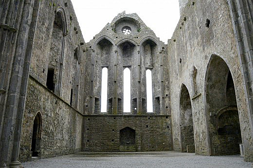
, the inspiration for Saint’s Rock. Before it was a cathedral, it was the castle of Brian Boru, High King of Ireland. Fun fact: Brian Boru is the reason there’s a harp on your Guinness can. He’s also the reason that there are pictures of harps all over everything in Ireland despite the fact that no one plays it or has any interest whatsoever in harps or harp music.

Anyway, Brian Boru’s great-grandson gave the castle to the church, who rebuilt it into a cathedral. While the castle was dismantled, the gates and curtain wall were left in place, which, combined with the Rock’s location on a steep hilltop, made it a very well-protected church.

There are a few differences between Saint’s Rock and the Rock of Cashel, the biggest of which was the removal of a secondary chapel building and the addition of the cloisters. The passages through the walls are actually real. This photo shows what the second floor passages look like from the ground (you can see them at the bottom of the windows).

So, with this done, Brazenthrone‘s Noble Quarter is next. It’s the second-largest chamber of Brazenthrone and it’s going to take a minute. I’ll get you some work-in-progress photos along the way. Sound good? All right.

There’s an annotated version of this map and DM notes available to patrons.

The Lighthouse Fortress of Torchguard

This map was chosen by the Cartographic Congress, based on the proposal by Parker. Originally, I wasn’t sure how I’d combine a castle and a lighthouse, but I really like how it turned out.

Torchguard is built on a rocky outcropping in the middle of a harbor. This puts it in a good position to defend against attacks by sea, but it also makes it a thing that ships might run into at night. Thus, the lighthouse atop the keep. An array of artillery, as well as docks to host its own fleet, help Torchguard keep unwanted ships from marauding the surrounding city.

Next up is Brazenthrone’s Common Quarter. It’s one of the bigger parts of the city and it’ll take a little while to draw, but I’ll give you some work-in-progress pics along the way.

Also, something I wanted to share: the other day, I went to the dentist and I had to fill out a form, which had a space for “occupation.” Writing “Fantasy Cartographer” on that line was one of the sweetest, most delicious moments of my life. I still can’t believe I do this. My god. Thank you so much.

There’s an annotated version of this map and DM notes available to patrons.

The Shattered Gates – The Last Remnant of an Ancient, Forgotten City

Normally, when I finish a map, I just open up my ideas notebook and pick another to do next. This time, as soon as I picked it up, I realized that all those ideas were up for a vote and I couldn’t draw them yet. So, I came up with this.

This is something I thought would be an interesting place to run an adventure. I didn’t have any particular sort of story in mind. Mainly I thought it’d make a unique lair for goblins, bandits or whoever else is getting their ass kicked this week. If you’re using it as an uninhabited ruin, here’s a version without the bridges.

After this is the Pits of Justice, then I think I’ll get started on Old Madeleine’s Inn and Fighting Pit. That’s an idea that’s been in the book for a long time and I’m really glad you guys picked it.

There are DM notes for this map available to patrons.

The High King’s Palace – Complete

Well, there it is. A little later than I’d hoped, but with my computer degenerating into a mass of dysfunctional electronics that necessitated several full hard drive wipes, I suppose that’s to be expected. You know what’s funny? I wiped my SSD several times over and you know what’s still there? Two things: Europa Universalis 4 and Stellaris. Apparently Paradox Interactive makes some highly resilient software.

Anyway, I need to get caught up, so I’m going to do the bridge map that I promised next, then the Cartographic Congress map, which will be a mine and mining camp. After that, more Brazenthrone. I’m not sure what part yet.

Also, sometime in the next week, I’ll be posting a second edition of Brazenthrone History and Lore.

There’s an annotated version and DM notes for this map on the patreon.

The High King’s Palace – Second Level – Featuring the Actual Brazen Throne

If you look at the top-center of this map, you’ll notice a large chair. That is the city’s titular Brazen Throne. It’s a large, tarnished hunk of brass that has been the Brasshand clan’s royal seat for several thousand years. In case you’re unaware, a lesser-used meaning of the word ‘brazen’ is “made of brass.” It didn’t get its name for being cheeky.

I’ll release the rest of the palace next, including the High King’s treasure vault, which is a gigantic, Scrooge McDuck-style landfill of money. I’ve been looking forward to drawing it and I hope you’ll dig it.

Anyway, here’s the version without the labels. There’s an annotated version and other stuff available to patrons, if you’re interested.

Brazenthrone – The High King’s Palace – Ground Level

This is the first of four floors of the High King’s palace. This took a while longer than usual because I laid out all four levels before finishing this one. But with that out of the way, the next three should come pretty quickly. Look for the second floor in around three or four days.

Well, like (I suspect) a lot of you, I recently got off the emotional rollercoaster that was the last episode of Game of Thrones, and… I really need to lie down. Jesus.

No labels here. There’s an annotated version blah blah blah patreon.

Neuschwanstein Castle

Neuschwanstein Castle

Here’s an alternate version with the tiles angled to follow the walls in the keep.

I was going to explain all the things that aren’t accurate about this map, but it’d take forever and it doesn’t matter anyway, so let me just give you the short version:

  • Only the bottom and upper two floors of the keep were finished and the unfinished floors currently contain a gift shop and a cafeteria. Since I thought that might spoil the mood a bit, I took some liberties and drew in what was intended to be there: servants’ quarters, guest rooms and a “Moorish hall.”
  • The cellar is in the right place, but I couldn’t find a floor plan, so I made some stuff up. I was tempted to draw a dungeon, but there is no way there’s a dungeon in there.
  • Nothing about this map conveys the ludicrous degree of splendor in the finished parts of this castle. It really is jaw-dropping. Have a look.

Anyway, I hope you like it. There’s an annotated version of this map with 83 rooms numbered and labeled, as well as all the usual stuff, available to patrons.

Neuschwanstein Castle – First and Second Levels

This is the first map I’ve ever made of a real place. It was built by King Ludwig II of Bavaria, who was known as “the Mad King.” He was born in the 1800s and was really into Middle Ages architecture, so he had this built as a sort of idealized fantasy castle. I’ll be honest, I can relate to this guy. Except I’m not the king of Bavaria and I can’t afford to build these things for real.

My understanding is that most of the rooms of this place are empty and I wasn’t able to find information on what a lot of them were actually meant to be, but since most people won’t be using this map as Actual Neuschwanstein Castle, I figured I’d come up things to fill them with.

Also, the cellar is completely made-up. There is a door there, which is visible in photos and the place does have a cellar, but I wasn’t able to find any information or floor plans to indicate what it looks like, so I just made it up. Everything else is drawn from various floor plans I found.

I’ll draw the rest of it next, but I thought I’d drop this off for now.

An annotated version of this map is available to patrons.