Coxton Tower: A Towerhouse in Moray, Scotland

Man, it’s been a while since I’ve made a map with only six rooms and I’d forgotten how fast I could draw something this small, haha.

Anyway, Coxton Tower was built in Moray, Scotland in the 1500s and this map is fairly accurate, with a couple of exceptions. First, it shows the tower on a clear, sunny day, which is a grossly inaccurate depiction of Scottish weather. And second, the size is off, which is intentional. An accurate map of Coxton Tower would have an interior about 3 1/2 tiles across. That’s a little tight for RPG purposes, so I doubled it.

Also, if you look at a photo of Coxton Tower, it’ll be a bit different from the map above. That’s because a staircase was built up to the second-floor entrance in the mid-1800s. I wasn’t sure whether to draw it with the staircase or the ladder, so I just drew it both ways. Here’s the version with the stairs.

There’s an interesting feature of Coxton Tower that I wanted to point out. It’s called a “yett” and, if you’ve never heard of one before, it may be because they’re mostly unique to Scotland. A yett is a metal gate, similar to a portcullis, but mounted on hinges so that it swings open like a regular door. It’s just behind the main entrance on the second level. You can see a photo of Coxton’s yett here.

Well, I hope you like the map! And yes, that is a deep-fried Mars bar on the kitchen table. I choose to believe that’s historically accurate.

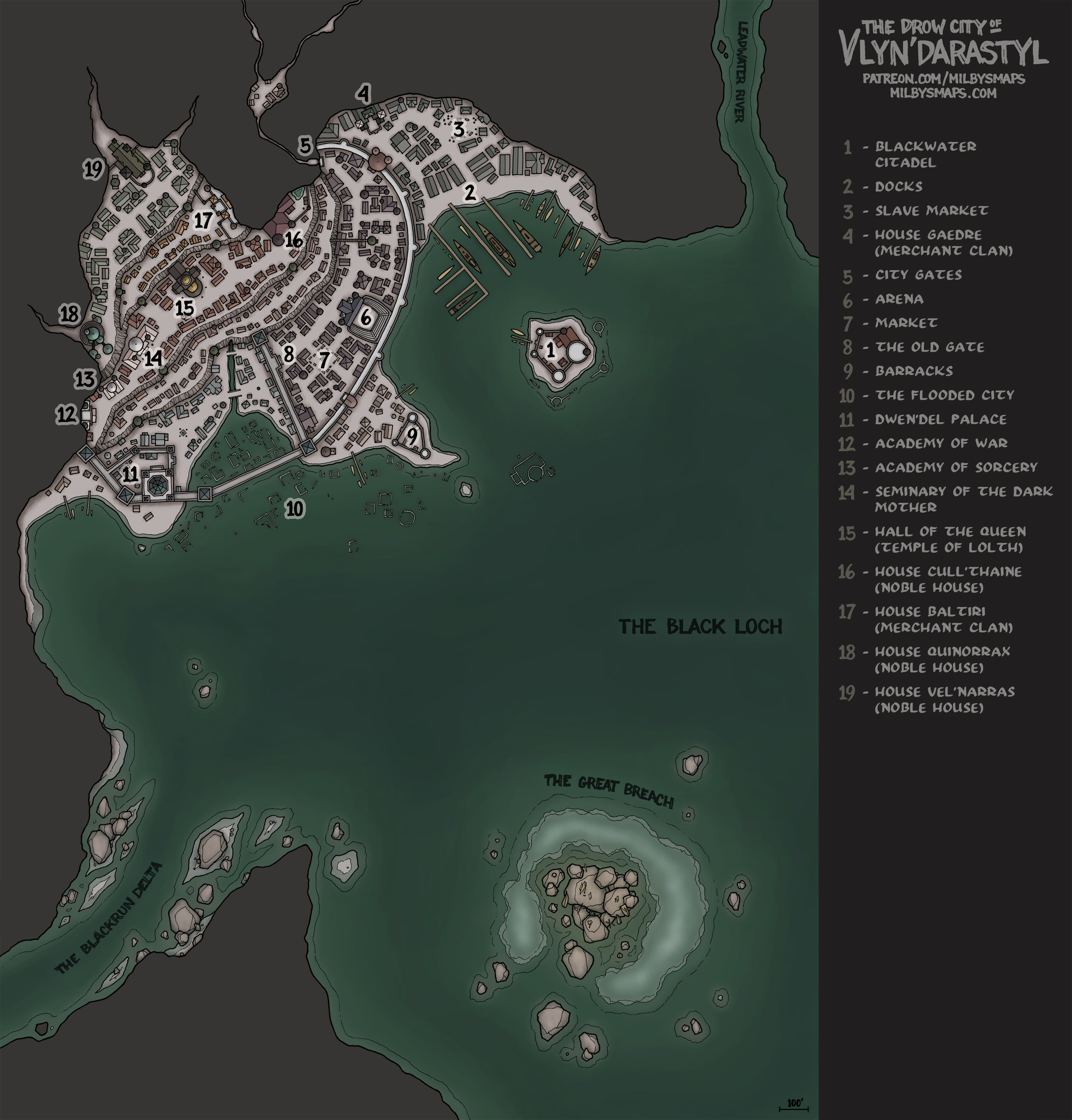
Next, I’ll be drawing another map from the Black Loch. This will be the drow noble estate of House Cull’thaine, the ruling house of the city of Vlyn’darastyl.

After that, I’ll be drawing a new spelljammer map. I know a lot of DMs put their players in my Dragonfly spelljammer last year and are getting ready to upgrade the party to a big boy ship, so I’ll be drawing you an elven Man-o-War to fill that role. It’ll be a bigger, better-armed ship for a mid-level party. And, for those of you who are planning to keep the campaign going into the higher levels, I’ll draw you the late-game war machine your players dream about later this year.

Okay, back to work!

The Town of Five Arches

Here’s the non-annotated version.

Five Arches might seem like a place you’d only find in the realms of fantasy, but you’d actually find something fairly similar in the realms of Italy– namely, the Ponte Vecchio in Florence. And there’s another bridge like this in Germany called the Krämerbrücke, as well as one in England called Pulteney Bridge. This map was heavily inspired by all three.

I think Five Arches would make a pretty interesting location for a “please sir, take back our town from the green people” type of adventure. It’s not the most original premise, but I think a unique setting can make that kind of adventure much more interesting. And those kinds of classic scenarios are the bread and butter of a lot of FRPGs. Most of us can’t reinvent the wheel every week.

Next up, I’ll be drawing Scotland’s 28th most famous castle, Coxton Tower. It’s not huge or epic, but it’s an interesting place with some distinctive character and I think it would suit a lot of encounters nicely. “Useful but unique” is one of the main things I aim for with my maps and I think Coxton Tower fits that description very well.

By the way, I’ve decided that the next historical map will be from India. I don’t know specifically what I’ll be drawing, but I decided on India for two reasons:

  1. There are some incredibly cool places in India.
  2. It’s India’s turn. I mean, it’s been India’s turn. They built this, this, that, this place, one of these and this thing and they still can’t get a fantasy map? At this point, I think they’re due.

Anyway, I’ve been looking over my options, but if you have any suggestions, by all means let me know in the comments (if you’re not a patron, you can leave a comment on my website).

Well, Five Arches was a bigger project than I thought, but it turned out exactly how I’d imagined it and I hope you like it too. Let me know what you think!

Town on a Bridge (Work-in-Progress)

Inking all this took a little longer than I expected, but here’s the town on a bridge. There are two levels on top of the bridge deck and another one underneath. The town has a tavern, a livery, various shops, a few gardens and a few empty buildings so you can add in whatever you need that isn’t there.

I’ve got a little bit left to ink tonight and then I’ll start on the color tomorrow. Anyway, what do you think so far?

The Whisperer – A Creature from the Black Loch

A few weeks ago, I posted a map called the Smoldering Abyss. It was part of the Black Loch and one of the more notable things living there was a monster called “the Whisperer.” Well, Jamie, a longtime patron, offered to write up some stats and do an illustration of the creature.

You can download it here. If it’s the kind of thing you’d like to see more of, Jamie and his partner Josh are making monsters over at their patreon page, Odd’s Gardens. Josh is an insanely talented artist and the dude is probably going to end up illustrating the actual Monster Manual one day, but, until then, he and Jamie are making their own.

By the way, let me just back up that last statement: This is Josh and this is the 5th ed. Monster Manual. Tell me I’m wrong.

Anyway, have a look at their stuff. The art is unreal and there are free versions of most of the creatures.

Well, I’m about to start inking the next map. It’s a town built on a bridge over a canyon and I’ll post photos once I’m done in a day or two. I’m really happy with it so far and I think you’re gonna like it. Okay, back to work.

The Black Loch: The History and Lore of the Loch

As promised, here’s an overview of the history and lore of the Black Loch. If you’ve read over all the DM notes for the loch, you probably won’t find much new here, but it’s intended as more of an introduction to the setting, with basic summaries of the locations and a few notable people. Of course, I’ll be updating this in the future, once I get some more locations finished.

Okay, time to get started on the next map!

The Ruins of Gyan’dis

Here’s the unfurnished version.

Gyan’dis is a ruined illithid settlement in the Black Loch. The colony thrived in its corner of the loch for over 800 years, until it was brought down and its inhabitants wiped out by Gyan’dis’ own elder brain. Normally, I’d talk a little more about the background of the map, but I’m going to leave that for a day or so, because I’m planning on writing up an overview of the history and lore of the Black Loch, which I can probably get done sometime tomorrow.

It’ll have basic information on the loch, along with brief summaries of the locations I’ve drawn so far. I think it’ll be a good introductory overview of the setting, which should be useful to patrons and non-patrons alike. Also, for non-patrons, I promise it’ll explain more about why the elder brain destroyed its own colony. I wouldn’t leave you hanging like that.

Once that’s done, I’ll be getting started on last month’s Cartographic Congress winner, a town built on a bridge over a river canyon. I’ve been champing at the bit to get started on that and it’s taking all my willpower to write up the Black Loch overview first. But it’s long overdue, it needs to be done and it’s only a day’s work at most, so I’m just going to bite the bullet and get it written.

After the bridge, I’ll be drawing the next historical map, Scotland’s Coxton Tower. And then we’ll probably find our way back to the Underscotland for another piece of the Black Loch.

Sound like a plan? Either way, let me know what you think!

Ard Skellig

Here’s a map of the interiors of the buildings and here’s a map of just the island with nothing on it.

Of the many Irish isles, one would have stood out to ancient settlers as a particularly good place to live. With its rolling hills, thick forests and an abundance of arable land, it was exactly what many of them were looking for. The island was called “Ireland” and, conveniently, it was the big one in the middle.

But for some people, Ireland was a bit too easy. They were looking for a challenge. These people wanted to make their homes on a smaller island, several miles offshore. Maybe a steep, jagged rock jutting out of the sea, preferably with no trees, very little flat ground, and, of course, no farmable land. Because agriculture is basically cheating.

A little ways off Ireland’s southwest coast, they found exactly what they were looking for: Skellig Michael. They headed over, built themselves a few big, stone beehives to live in, and enjoyed spending the rest of their lives away from the fast-living, hectic lifestyle of rural Kerry.

Then, over 1000 years later, Luke Skywalker showed up. Seriously. If you recognize this place, that’s probably why. In 2015, part of Star Wars: The Force Awakens was filmed on Skellig Michael. And if the island’s name rings a bell, that’s probably because you’ve played the Witcher. The Kingdom of Skellige is named after it. I’m not sure how the producers of Star Wars or a Polish author even knew this place existed, but apparently it’s more famous than you’d expect.

Anyway, next, I’ll be drawing another map from the Black Loch. This time, I’ll be drawing the ruins of an Illithid settlement, which should be a pretty interesting place to explore. After that, I’m going to draw the map chosen by last month’s Cartographic Congress, which I am ridiculously excited about.

Once in a while, someone proposes something to the Cartographic Congress that’s very similar to an idea I’ve been wanting to draw for a while. And, once in a while, that proposal wins. This is that proposal: a town built on a bridge over a river canyon.

I’ve seen a couple maps based on similar ideas before, but I’ve got a whole different sort of thing planned. I’m planning to draw buildings along the sides of the bridge, plus a lower level underneath the bridge deck, and hollow spaces inside the support pylons. I want to have the settlement extend into the cliffsides beneath the bridge as well. I’ve got a big vision for this and I think it’s going to be really cool, either as a settlement or as a dungeon to explore.

Well, that’s it for now. Hope you like Ard Skellig. Let me know what you think!

Mountainous Island Settlement (Almost Finished)

I wanted to show you what’s been taking so long. The rest of the island is done as well, I just need to color the interiors of the buildings. That should take one more day, two at most.

By the way, this island is based largely on Skellig Michael in Ireland. My wife convinced me to draw the buildings like the ones they have there, which are very unique. Which is to say, they’re big, stone beehives.

Anyway, I’m going to try hard to finish this up tomorrow, so I’d better get back to work!

Mountainous Island Settlement (Work-In-Progress)

As sometimes happens with me, I started on this map with relatively humble plans, which ended up becoming a bit more grand. I’ve spent the last week drawing this island and now I just need to draw some buildings to put on it and we’ll have our town. I think I’m going to draw some caves underneath it as well, but I’m not sure yet.

Anyway, this is a real island and I’m curious if any of you would recognize it. At least 50% of you have seen it before, probably more like two thirds. Not in person, but it was in a movie from the last ten years. Also, there’s a location in a popular video game named after it. I’d guess that 5-10% of you have played it. Feel free to leave a comment and I’ll tell you if you’re right.

Okay, back to work!

The Grinning Widow: A Ship for the Seas of the Underdark

The Grinning Widow is a ship designed for the Black Loch. In an underground sea, sails aren’t going to accomplish much, so the Widow doesn’t have any. She’s a galley, powered exclusively by rowing, with a crew of 20 oarsmen who all look like they walked out of a “skipped leg day” meme.

For defense, the Widow is armed with a ram on the bow, as well as two ballistas, one of which is a little scarier than the other. You see, I’ve been drawing the “big crossbow” ballista in my maps for a while now, but I wanted to change things up a bit, so I started searching for different ballista designs. I found a few I liked, but then– out of nowhere– this thing struts into the room. Yes please.

I don’t know if it’s real and I don’t care. It’s awesome and I decided it was definitely going in the map. I made a token of it, too, by the way, as well as the other one. You can get them both here. Personally, I’d give it around double the range and damage of a regular ballista in the DM’s Guide, but require a 2-person crew to fire it every round. And give it +1 to damage if the party names it.

So, here’s a funny story from my game. A few years ago, my players spent some time on a ship like this one, down in the underdark. The orog crew ended up teaching them Orcish, which my wife’s elven wizard got quite good at.

Several months later, she’s with a different party, being confronted by orc bandits, and she uses her knowledge of Orcish to speak with them.  The bandits look at each other and burst out laughing, which leaves the party confused. Finally, the orc leader stops laughing and tells her he’s never heard an elf in a fancy dress speaking Orcish. And he never imagined that, if he did, she’d be speaking the filthiest Orcish he’s ever heard.

They end up eating with the orcs, who tell her that everything she says is heavily laced with curse words. She hadn’t realized it, but the orog sailors taught her to speak like they do, which is very crudely, even by Orcish standards. So she knows the language, but she can’t speak it without cursing. Fortunately, orcs don’t tend to be prudish about that kind of thing, but no one expects it from someone like her.

Anyway, next up, I’ll be drawing a mountainous island settlement. And after that, I’ll be coming back to draw something else from the Black Loch. Maybe the illithid ruins? We’ll see.

Well, I’m gonna grab some coffee and start sketching some islands. Let me know what you think of the Widow!

There’s an annotated version of this map and DM notes available to patrons.