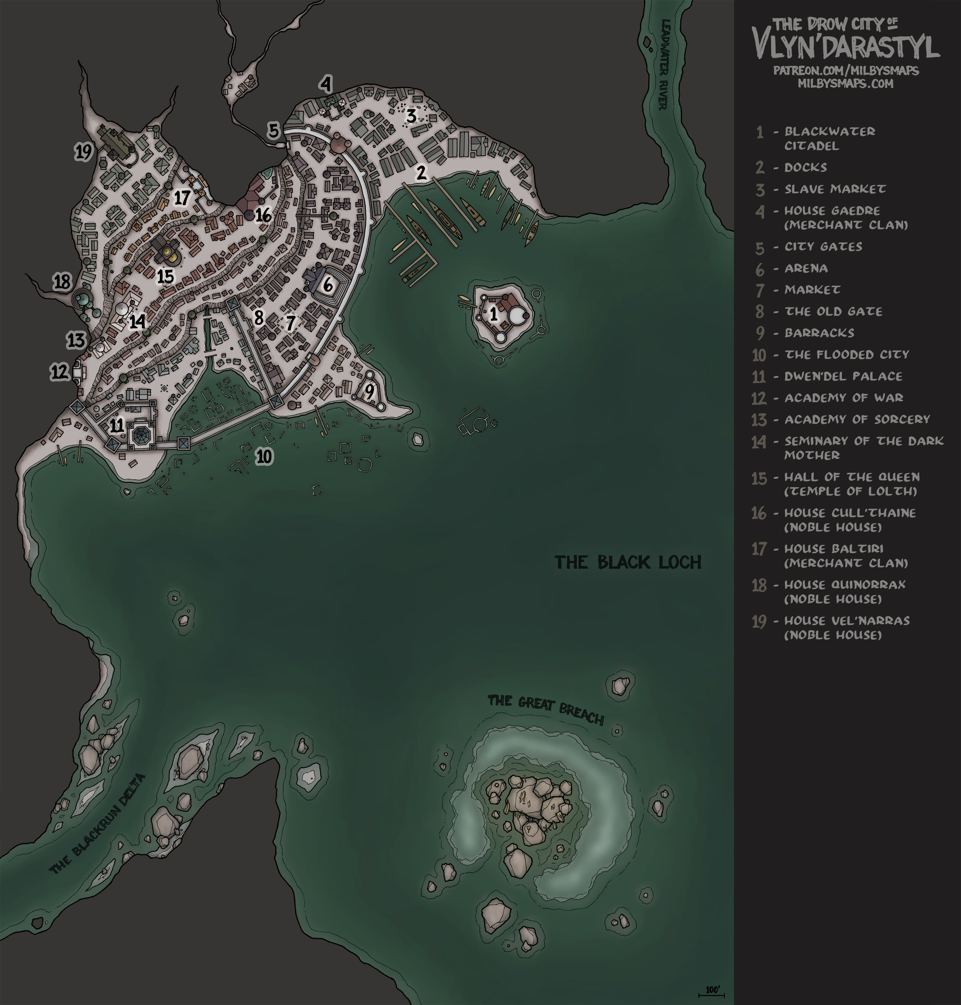
The Streets of Vlyn’darastyl – Roof Level

I never know what to say when I post the roof level of a map. “Hey, here’s a useful, but slightly less interesting version of the last map I made!” Whatever, let’s talk about the Black Loch instead.

The loch is about 2/3 of the way done so far and, lately, a lot more people have been messaging me about it. The same thing happened when I was 2/3 of the way through Brazenthrone. The reason is that a lot of people are starting to use it. What I’ll be drawing next doesn’t matter as much when your future campaign is going to be there. But when your current campaign is there, it becomes a lot more relevant.

So, I wanted to list the unfinished locations here, along with whatever I’ve got planned for those places. Also, this is roughly the order I’ll be drawing them in:

  1. Travelers’ Ruin – A ruined structure on the coast of Cairnhollow Isle. The Tideborne orogs from the Deep Spire dock here to hang out and drink from time to time.
  2. Drow Settlement – A small drow community.
  3. Ancient Crypt – No specific plans yet, except that there will be at least one box with a dead person inside it.
  4. Grimlocks – A grimlock settlement.
  5. The Blind Colossus – A huge, eyeless statue standing in the middle of the loch. It will have an interior.
  6. Aboleth Lair – The lair of an aboleth named Psor’il and its minions.
  7. Submerged Ruins – No plans yet.
  8. Duergar Outpost – A small outpost built by the duergar to conduct trade and keep an eye on the loch.
  9. Fortress Ruins – The burnt-out ruins of a fortress near the Isle of Ash.

In addition to the above, there will be one more map that has yet to be decided on by the Black Loch Conclave. I’ll draw it whenever the final vote has ended, which means it’ll probably be first or second.

Anyway, that’s about it. If you’re running a game in the loch right now, I hope things are going well and I’d love to hear what your party has been up to!

The Streets of Vlyn’darastyl

This is a battlemap for the Drow City of Vlyn’darastyl. It’s mostly meant to be a backdrop for encounters your party might have in the city, but I figured I’d throw a tavern, a shop and a small market in there to give it a little extra utility. By the way, these buildings don’t actually correspond to anyplace on the city map, so don’t go crazy trying to find them. Hopefully no one did that before reading this far.

I’m going to draw a roof-level version of this map as well, which should only take a day or two. After that, I’ll be drawing the map chosen by last month’s Cartographic Congress, the Infected Citadel. This is a small, dwarven hold that’s been tainted by the Far Realm. Things will look fairly normal at the top, but, as you descend, it starts to get stranger and stranger, until reality just completely breaks down at the bottom. Like, the floor becomes a thick mass of worms writhing around giant horse eyeballs. And there’s an eight-eyed fish head sticking out of the wall. Or something like that, I don’t know.

Honestly, I have no idea how I’m going to draw this place, but I’m very much looking forward to figuring it out. I promise you that it will be full-on crazy time.

Anyway, I’m gonna go post the last five proposals for the Black Loch Conclave. Let me know what you think of the map!

Eel’s Maw Stronghold

The kuo-toa get no respect. I don’t mean from lorebooks, I mean from DMs. When you’re writing an underdark campaign and you need a powerful empire, who do you think of? The drow, sure. The illithids, of course. Maybe the duergar. But the kuo-toa? No, those are trash enemies for random encounters. I mean, sure, sometimes they play a significant role in a story, but they hardly ever take center stage.

Well, the kuo-toa of the Black Loch aspire to a little more than jumping out of the water and getting decapitated by your half-orc barbarian. They’ve got plans to take over the loch and subjugate the other races. Including your precious drow.

The plan is crabs. Siege crabs. Crabs the size of your house with carapaces a foot thick. Walls don’t save you from that. Soldiers don’t save you from that. Running for your life? That might do it.

The kuo-toa have been breeding siege crabs in the caverns below the Eel’s Maw Stronghold for decades and, as soon as the next brood reaches maturity, they’ll be ready to kick things off. The kuo-toa intend to move up in the world, or at least wreak enough havoc to take everyone else down a peg or two.

Next up, I’ll be drawing another map from the Black Loch. This will be a battlemap for the drow city of Vlyn’darastyl. It’ll be a few streets with some houses and shops. Nothing too fancy, just something that’ll make a good backdrop for encounters in the city. I don’t expect it to take too long.

By the way, I thought I’d give away the DM notes for this map, so you can download those here. Also, here are some siege crab tokens and a trebuchet token I made.

Well, that’s it for now. Let me know what you think!

The Citadel of Ash

A lot of people will look at this map and see a place inhabited by one of two things:

  1. Bad guys
  2. Dwarves

Why? It’s the lava, of course. Lava in FRPGs is practically code for dwarves and scumbags. It’s almost like decent, respectable humans can’t recognize the defensive utility of molten rock.

Hopefully, this isn’t how it works in real life, because I recognize the defensive utility of molten rock. And I’m a little too tall to be a dwarf.

Anyway, the first vote of the Black Loch Conclave started yesterday and, if you’re a patron, you should go cast a vote. There are some amazing ideas people have proposed for this and I really want to see what everyone decides on. Honestly, there are a few proposals that have inspired me so much that I’m thinking of incorporating some of their ideas into other maps if they don’t win. I am so glad I did this.

Next up, I’ll be drawing the Kuo-Toa Stronghold from the Black Loch. Like the Mother’s Eye, it’s going to be partially underwater. I don’t think I’ve seen a map of a semi-submerged castle before, so this should be fairly unique, or at least not something there are a million of out there. And, once it’s done, I should have time to knock out another one or two Black Loch maps this month.

Anyway, I’m gonna get to work. Let me know what you think of the Citadel!

The Mother’s Eye

The Mother’s Eye is a kuo-toan temple partially submerged in the waters of the Black Loch. The part of the temple above water is meant, perhaps surprisingly, to accommodate land-dwelling races.

Do land-dwelling races worship naked lobster lady? No, but they make great sacrifices. And kuo-toa do human sacrifices like Brazilians play soccer.  They love it, they’re great at it, it’s kind of their thing. It’s not their only thing, of course. But, you know, it’s a big one and they work hard at it. You’ve gotta respect that.

The kuo-toa of the Black Loch have big plans and I’ll talk more about what those are when I draw the kuo-toa stronghold, which I’m probably going to do within the month.

But first, there are two things to do. The first is to make an alternate version of this map with the temple on land. I figure that, if I’m going to draw an Aztec/Mayan style pyramid and put it underwater, I should probably make a version that isn’t underwater while I’m at it. It should only take a day to get done.

After that, I’ll be drawing the map chosen by last month’s Cartographic Congress: a tower fortress, similar to a smaller version of Barad-Dûr (from Lord of the Rings).

Anyway, that’s it for now. If you’re a patron and you’ve got an idea for a new location for the Black Loch that you’d like to add to the upcoming vote, you’ve got another week to let me know. Speaking of which, the ideas people have submitted so far are really good. Like, REALLY good. I can’t wait to see which one you go for.

Man-O’-War-Class Spelljammer

Here’s a version of the map with extra crew quarters. And here are some tokens of the ship and the weapons.

There’s a time in every Spelljammer campaign when the party has finally committed enough crimes and looted enough corpses to afford a new ship. Maybe not the Doomlord-Class Planetary Sterilizer they’ve always wanted, but something better. They’ve been cruising around in a stylish, but poorly-armed bugboat for about eight levels now. They used to love it, but now… well, the decks are stained with blood, they’ve got three NPCs sleeping on the floor, and there isn’t a square inch of the ship that the wizard’s familiar hasn’t peed on. So they head down to the shipyard to buy themselves a big boy spelljammer.

The Man-O’-War is an elven-designed light warship with lots of cargo space, seven officers’ cabins, and enough firepower to hold its own against most of what the old ship had to run away from. The four ballistas are fairly standard, but the catapult is a little more interesting. Instead of using rope and wood to launch a projectile, this catapult uses a high-pressure boiler that builds up steam, which can be released to fire the weapon.

But the best thing about the Man-O’-War is, arguably, the rear cargo doors. They can be used to load or unload cargo or passengers, either on land, or *ahem* mid-flight. An excellent way to prevent overcrowding in the brig.

Earlier, I said I was planning to draw another spelljammer later this year, but I think I’m going to make it at least two, with the next one coming in three months or so. It’ll be a bigger ship than the Man-O’-War, something beefy to use as a late-game vessel. I’ll probably hold a vote on which ship to draw when I’m ready to get started on it. I know there aren’t a lot of maps out there for Spelljammer and I want to draw a few more for those of you running games in the setting. With the Dragonfly, the Man-O’-War and the next one, that’ll give you an early-game, mid-game and a late-game ship, which at least covers the fundamentals. After that, I’ll see where you want me to go from there.

Next, I’ll be making some things for the Black Loch. Since a campaign in the loch would probably be a naval campaign, a water map and some ship tokens would be helpful for a lot of people. Someone pointed this out to me recently and I’m going to go ahead and make them now. It’ll take a day or two at most and, afterwards, I’ll probably get started on another Black Loch map.

Okay, that’s it. Let me know what you think!

The Cull’Thaine Estate

The Cull’Thaine Estate is home to the drow matriarch of House Cull’Thaine, the ruling family of the city of Vlyn’darastyl in the Black Loch.

Something about this map got me thinking. There are two parts of the Black Loch— the setting I’ve been making maps and lore of– that came from the Cartographic Congress: the Cull’Thaine Estate and Vlyn’darastyl, where the estate is located.

Over a year ago, a patron named Matt proposed an idea to the Cartographic Congress that won the vote and became Vlyn’darastyl. One of the locations marked on that map is the estate of House Cull’Thaine. A month ago, a patron named AN7 proposed a map of that house’s estate. That proposal won and now we have this map, which three people have had a hand in creating.

Without Matt, Vlyn’darastyl wouldn’t exist. Without AN7, the Cull’Thaine Estate would be a dot on the map. And the Black Loch was my idea, but none of it would exist without the rest of my patrons. So, this has become something of a collaborative effort over time. And I’d like it to become more so.

I want to give EVERY patron a voice in how the Black Loch comes together. So, here’s the plan: later this month, I’m going to take proposals from ALL patrons for a new location in the Black Loch. Then, I’ll have a vote on those proposals, which all patrons will be able to participate in. We’ll have a series of runoff votes until one proposal remains and that will become a new location in the Black Loch.

After I’m done with the next map, I’ll send out a message to all patrons calling for proposals. Then, once I’ve given a week or two for everyone to submit their ideas, I’ll start the voting. I don’t know how many proposals to expect, but the Cartographic Congress usually gets 5-10 proposals every month, so I think 40+ is possible here. Realistically, if I put 40 options on a single ballot, no one is going to read them all, so I’ll hold multiple votes, once a week, with 10 options on each ballot. The top two proposals from each will go on to a final ballot, which we’ll whittle down to one winner.

Anyway, that’s the plan. I’ll send out a message with more details when I’m done with the next map, so you can just reply to that if you have a proposal. Also, to be clear, a separate Cartographic Congress vote will be held as usual.

The next map will be a Man-o-War-class spelljammer, but first I need to make a quick edit to the map of Vlyn’darastyl. The Cull’Thaine Estate looks different from the way I drew it on the city map, so I want to make a revised version that matches. I’ll have that done in a few hours.

EDIT: The revised map of Vlyndarastyl is finished: annotated version, non-annotated version.

Okay, that’s it! If you’ve got any thoughts on the map, the vote or anything else, let me know!
Coxton Tower: A Towerhouse in Moray, Scotland

Man, it’s been a while since I’ve made a map with only six rooms and I’d forgotten how fast I could draw something this small, haha.

Anyway, Coxton Tower was built in Moray, Scotland in the 1500s and this map is fairly accurate, with a couple of exceptions. First, it shows the tower on a clear, sunny day, which is a grossly inaccurate depiction of Scottish weather. And second, the size is off, which is intentional. An accurate map of Coxton Tower would have an interior about 3 1/2 tiles across. That’s a little tight for RPG purposes, so I doubled it.

Also, if you look at a photo of Coxton Tower, it’ll be a bit different from the map above. That’s because a staircase was built up to the second-floor entrance in the mid-1800s. I wasn’t sure whether to draw it with the staircase or the ladder, so I just drew it both ways. Here’s the version with the stairs.

There’s an interesting feature of Coxton Tower that I wanted to point out. It’s called a “yett” and, if you’ve never heard of one before, it may be because they’re mostly unique to Scotland. A yett is a metal gate, similar to a portcullis, but mounted on hinges so that it swings open like a regular door. It’s just behind the main entrance on the second level. You can see a photo of Coxton’s yett here.

Well, I hope you like the map! And yes, that is a deep-fried Mars bar on the kitchen table. I choose to believe that’s historically accurate.

Next, I’ll be drawing another map from the Black Loch. This will be the drow noble estate of House Cull’thaine, the ruling house of the city of Vlyn’darastyl.

After that, I’ll be drawing a new spelljammer map. I know a lot of DMs put their players in my Dragonfly spelljammer last year and are getting ready to upgrade the party to a big boy ship, so I’ll be drawing you an elven Man-o-War to fill that role. It’ll be a bigger, better-armed ship for a mid-level party. And, for those of you who are planning to keep the campaign going into the higher levels, I’ll draw you the late-game war machine your players dream about later this year.

Okay, back to work!

The Ruins of Gyan’dis

Here’s the unfurnished version.

Gyan’dis is a ruined illithid settlement in the Black Loch. The colony thrived in its corner of the loch for over 800 years, until it was brought down and its inhabitants wiped out by Gyan’dis’ own elder brain. Normally, I’d talk a little more about the background of the map, but I’m going to leave that for a day or so, because I’m planning on writing up an overview of the history and lore of the Black Loch, which I can probably get done sometime tomorrow.

It’ll have basic information on the loch, along with brief summaries of the locations I’ve drawn so far. I think it’ll be a good introductory overview of the setting, which should be useful to patrons and non-patrons alike. Also, for non-patrons, I promise it’ll explain more about why the elder brain destroyed its own colony. I wouldn’t leave you hanging like that.

Once that’s done, I’ll be getting started on last month’s Cartographic Congress winner, a town built on a bridge over a river canyon. I’ve been champing at the bit to get started on that and it’s taking all my willpower to write up the Black Loch overview first. But it’s long overdue, it needs to be done and it’s only a day’s work at most, so I’m just going to bite the bullet and get it written.

After the bridge, I’ll be drawing the next historical map, Scotland’s Coxton Tower. And then we’ll probably find our way back to the Underscotland for another piece of the Black Loch.

Sound like a plan? Either way, let me know what you think!

Ard Skellig

Here’s a map of the interiors of the buildings and here’s a map of just the island with nothing on it.

Of the many Irish isles, one would have stood out to ancient settlers as a particularly good place to live. With its rolling hills, thick forests and an abundance of arable land, it was exactly what many of them were looking for. The island was called “Ireland” and, conveniently, it was the big one in the middle.

But for some people, Ireland was a bit too easy. They were looking for a challenge. These people wanted to make their homes on a smaller island, several miles offshore. Maybe a steep, jagged rock jutting out of the sea, preferably with no trees, very little flat ground, and, of course, no farmable land. Because agriculture is basically cheating.

A little ways off Ireland’s southwest coast, they found exactly what they were looking for: Skellig Michael. They headed over, built themselves a few big, stone beehives to live in, and enjoyed spending the rest of their lives away from the fast-living, hectic lifestyle of rural Kerry.

Then, over 1000 years later, Luke Skywalker showed up. Seriously. If you recognize this place, that’s probably why. In 2015, part of Star Wars: The Force Awakens was filmed on Skellig Michael. And if the island’s name rings a bell, that’s probably because you’ve played the Witcher. The Kingdom of Skellige is named after it. I’m not sure how the producers of Star Wars or a Polish author even knew this place existed, but apparently it’s more famous than you’d expect.

Anyway, next, I’ll be drawing another map from the Black Loch. This time, I’ll be drawing the ruins of an Illithid settlement, which should be a pretty interesting place to explore. After that, I’m going to draw the map chosen by last month’s Cartographic Congress, which I am ridiculously excited about.

Once in a while, someone proposes something to the Cartographic Congress that’s very similar to an idea I’ve been wanting to draw for a while. And, once in a while, that proposal wins. This is that proposal: a town built on a bridge over a river canyon.

I’ve seen a couple maps based on similar ideas before, but I’ve got a whole different sort of thing planned. I’m planning to draw buildings along the sides of the bridge, plus a lower level underneath the bridge deck, and hollow spaces inside the support pylons. I want to have the settlement extend into the cliffsides beneath the bridge as well. I’ve got a big vision for this and I think it’s going to be really cool, either as a settlement or as a dungeon to explore.

Well, that’s it for now. Hope you like Ard Skellig. Let me know what you think!