Brazenthrone – The Eastern Halls – Ground Level

Here’s the annotated version.

These are the residential chambers on the lower-right side of this map surrounding 17, which is the fountain in the center. I’ve got all three levels of this drawn already, so the rest should be up in a day or two. I just need to color them. I’m also going to update the map in the link to include all the residential chambers. I’ve been meaning to post my Roll20 landing page too. It’s… a little different. There are going to be a lot of posts this week.

Once those are up, I’m going to start on something a little more interesting: the Old Quarter (7&8 on the map above). Originally the center of Brazenthrone, it was abandoned and sealed off following a disaster that left the entire chamber in ruins. What that disaster was, exactly, I’m not sure. But I’ll know by the time I’m done and it’ll all be explained in the DM notes.

All right, I’m gonna go knock out the rest of this thing!

Brazenthrone – The Hall of Iron – Everyone’s Edition


The Hall of Iron is a residential district of Brazenthrone. Admittedly, having nothing but residences, it’s not the most exciting part of the city. But a city needs homes and not everyone can live in some kind of dwarven Winchester Mystery House (here, let me save some of you the time).

This is one of a cluster of residential chambers surrounding a fountain plaza, which you can see here (17 and the nearby unlabeled chambers). I’ve decided to do the plaza and the rest of these chambers as one map, which I’ll add this to. That’ll let me consolidate everything into a single annotated version and a single page of DM notes, which is handy because, frankly, there isn’t much notable stuff here. This is Brazenthrone’s version of suburbia.

Next up is last month’s Cartographic Congress winner, The High Temple of Mystra, a massive library and storehouse of arcane objects dedicated to the goddess of magic. After that, more Brazenthrone, of course.

You can download all print and VTT versions of this map from this post on my patreon or from Google Drive.

Brazenthrone – The Bloody Hall – Everyone’s Edition


Here are the DM notes. There is no annotated version, since all the rooms are residences.

The Bloody Hall is a residential district of Brazenthrone, located just south of the Common Quarter. It’s unique on account of all the residences here being in a single, large building formerly known as “Amber Manor.” There are more details in the DM notes if you’re interested.

Next up is the Hall of Iron, another residential district adjacent to the Common Quarter. After that, I’ll be doing last month’s Cartographic Congress winner, the High Temple of Mystra. Then it’ll be back to the mountain for the rest of the Brazenthrone maps I owe you. There’s not too much of the city left to go!

All the print and VTT content for this map is available on my patreon here or on Google Drive.


Brazenthrone – The Gnomestown District – Everyone’s Edition


Here’s the annotated Patrons’ Edition and the DM notes. I’m still giving away all my new patron content for free while everyone is stuck inside. You can get it from my patreon here or from Google Drive.

Brazenthrone returns! This is the first of a number of Brazenthrone maps I’ll be drawing in a row. Gnomestown is pretty much what it says on the label: a small corner of the city where a lot of the gnomish residents live. Most of these would be deep gnomes, with whom the dwarves of Brazenthrone have a tight relationship.

The “Tavern in the Sky” at (5) is a good place to hang out if you’re three feet tall and everyone else in the city has a liver like a bank vault and casually drinks an amount of alcohol that would kill your entire family. If the name seems confusing, here’s the explanation from the DM notes:

The name of this tavern makes plenty of sense to deep gnomes, but almost none to anyone else. The gnomes‘ perspective is this: most deep gnome communities are miles below ground. While Brazenthrone is under a mountain, the city and it’s entrance are fairly high up in the mountains and the city is, in fact, at a higher elevation than most surface cities. Thus, it is– according to the deep gnomes– “in the sky.” To be clear, the sky is in no way visible from this location.

Next up is the Old Mines, east of the Noble Quarter. They’re long abandoned and blocked off from the city, which makes them sort of a “wilderness.” But, you know, maybe somebody forgot something in there and maybe your party needs to crawl on in and go get it. It’ll be fine. It can’t be that bad, can it? I mean, of course it can, but… look, just get in the hole.

Before that, I’ll post another batch of tokens I made for my Roll20 game. Those should be up tomorrow. Until then!

The Drow City of Vlyn’darastyl – Everyone’s Edition


First, the annotated version, the DM notes and this other version.

This was a slightly unusual map for me. When I say I’m drawing a “city map,” it usually means something like Brazenthrone or Finbarr’s Marsh. Drawing an exterior-only city had me a little worried, since the last one I did was this piece of white-hot garbage. God, that’s embarrassing. But I think Vlyn’darastyl is big step up from that.

So, Vlyn’darastyl is a drow city that’s accessible by airship, which isn’t a characteristic shared by many other cities two miles underground. But the Great Breach– a 300′ (100m) hole in the roof of the cavern leading to the surface sea above– makes this possible. There are more details in the DM notes above, but if you’ve got any other questions I didn’t cover, feel free to ask.

Thanks to Senator Matt for proposing this map to the Cartographic Congress! He and I were talking about an idea I had for the future which I’d like to let you in on.

At some point, I want to make a map of a small Underdark sea. That sea is the Black Loch, which the map above shows only a small corner of. I want to make a larger, region-sized map of the whole loch with 10-12 locations marked: maybe a kuo-toa village, a duergar outpost, a few islands with some ruins, a series of caves, maybe something underwater, stuff like that. Then I’d draw maps of each of those locations at a 5′ scale, so you’d have this map of a whole region and, wherever you wanted to take your players in that region, you’ve got a map of it ready to go.

When Matt proposed a city next to an Underdark sea, I thought that seemed like a good addition, especially since the Great Breach makes the area more accessible for DMs whose parties aren’t currently below ground. But– to be clear– this is the only part of it I’ll be making for a while. This is a big project and I’m not going to be starting on it until Brazenthrone is finished, which will be a while still. But I thought I’d share that with you and see if anyone had any thoughts.

As I said when I posted the last map, all patron content is free to everyone this month. You can download it from this post or from Google Drive.

Mont-Saint-Michel – Fourth Level

Here’s the annotated version, the elevation guide and the DM notes. If you need the free VTT stuff, it’s on the patreon.

It’s been quite a journey, but here we are at the end. Time to chuck the ring into the volcano and start on the next adventure.

To all my patrons, thank you so much for giving me the opportunity to make this. I try to draw maps that no one else makes and create unique settings for your games. Hopefully Mont-Saint-Michel will serve you well.

The elevation guide is up there. The French version isn’t, but my French language consultant is coming over for D&D in an hour and I should have it up tomorrow morning. Tonight, I’m gonna DM my game and celebrate the end of this project with fermented beverages.

Starting tomorrow, I’m getting to work on the backlog of Cartographic Congress maps. First up is Predjama Castle, a Slovenian castle built in the mouth of a cave.

There are hi-res print versions and a whole lot of VTT versions of this map available to patrons.

Mont-Saint-Michel – Third Level


Here’s the annotated version and the finished DM notes. The free VTT stuff is on the patreon.

This is almost everything. The DM notes are done too, although I reserve the right to change my mind about that tomorrow. There are a couple things left to do:

  • Color the roofs. Easy, easy stuff.
  • Make furniture tokens. I promised someone I’d make them so they can mod the Mont. Even easier.
  • Stacked floor maps for VTT. Here’s one that’s finished so I don’t have to try to describe them. A patron told me this is how he used Finbarr’s Marsh: he’d use the roof map when players were outside, then, when they entered a building, he’d change to a map like the one there, with all the levels in one. I liked the idea and I’m making them for this. Let me know what you think.
  • The elevation guide. I’m making that from the roof level, so it should be up at the same time.
  • I’m still planning to make an annotated version en Francais, but I need my French friend to check it first, so it might be a minute.
  • Anything else I’m forgetting, which is hopefully nothing. Slap me if I’m wrong about that.

Mont-Saint-Michel – Second Level


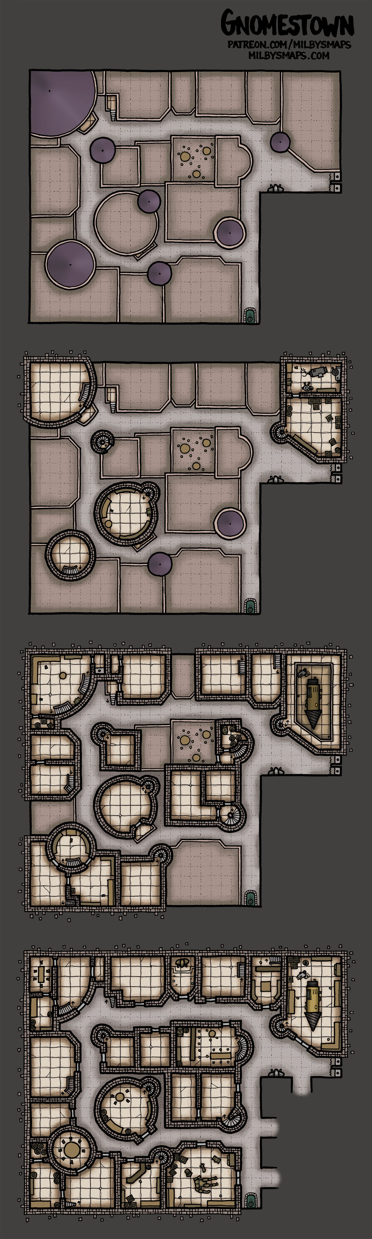
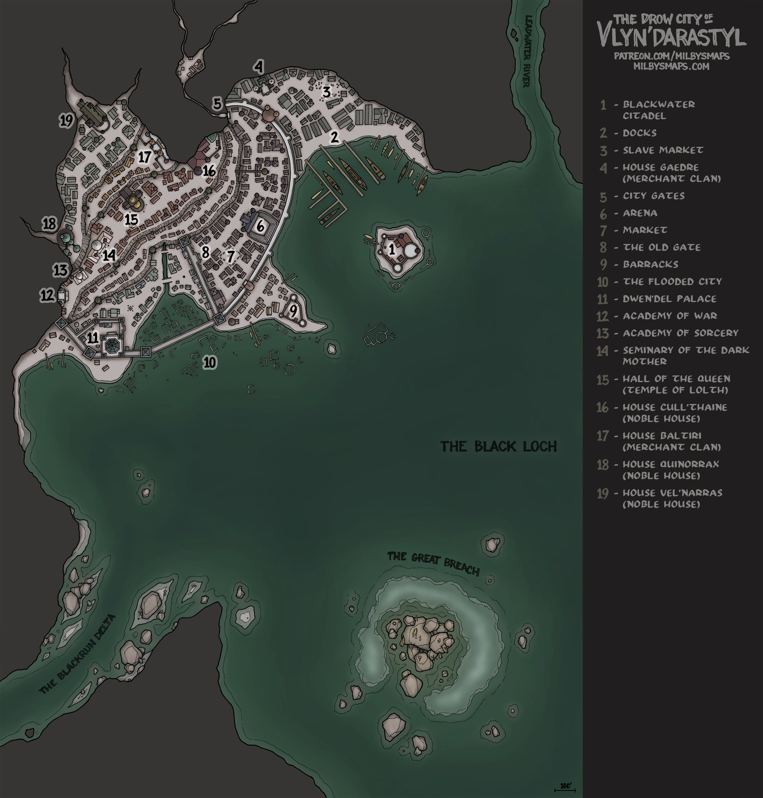
First: here’s the updated DM notes and the non-annotated version of the map. And the basic VTT files you’ll need to use this on Roll20 or FG are attached to the bottom of this post.

I’ve talked about the map a lot. I feel like talking about my D&D game today.

So I recently started running a game for my friends again after about a year and it feels good to be behind the screen again. Our group is… a little atypical.

First, it was almost the case that every person in the group was from a different country. I, the DM, am American. The wizard (and my wife) is Irish. The druid is Spanish. The monk is French. And the paladin is Norwegian. But, at the last minute, we went double-Spanish, which ended up being a good thing, since he played a rogue, which is a good thing for any party to have. And since, during the first session, he was the only person who seemed to be able to roll double-digit numbers on a D20, allowing the party to slowly but eventually kill the small number of poorly-armed goblins I’d put before them.

We also later got another Irish player who became the party’s ranger. Which brings me to the second unusual thing: the names. Oh my god.

So, the ranger is, ahem, “Polycarp Manius.” Um. Okay.

The monk is “Morzaninov,” which has something to do with how “more than enough” is pronounced with a French accent.

The wizard has a mile-long super-elvish name that I can’t remember.

The paladin is “Adobos,” which is passably normal.

The druid is “Blyantspisser,” which is the Norwegian word for “pencil sharpener.” Seriously.

And the rogue is “Garrett,” which, in this party, seems so oddly normal it’s almost mundane, like a character named “Bob” or “Gary” would be in most parties.

So that’s the group. They’re making their way through Lost Mine of Phandelver at the moment and they’re getting better at rolling dice. I’ll let you know how it goes.

Mont-Saint-Michel – Ground Level


Here’s the annotated version and the DM notes.

This is what the last few months have been leading up to. Hopefully it’s everything you were expecting. There’s still the upper floors to color and a few other little things to do, but we’re almost there.

A few things. First, DM notes for everybody. There are some things we need to talk about with this one and that’s where we’re talking about them. It’s all under “Important Things.” Feel free to stop reading after that if you want.

Second, non-patrons will notice a ZIP file attached to this post on the patreon. If you play on a VTT, you’ll need those. They’re individual sections of the map so you don’t have to try to get Roll20 or Fantasy Grounds to try to choke down the whole island at once. There are more VTT options for patrons, but I want everyone to be able to use this and those files are necessary for that. I care about those of you who aren’t giving me money too, you know.

Third, the DM notes are only half-finished. I wanted to get this posted and I’m not letting a little thing like incomplete DM notes stop me.

Finally, there’s going to be an elevation guide and some other VTT options to come, but those will require multiple floors to be finished, so they’ll come at the end.

Anyway, what do you all think? If you’ve got any questions, just ask. I may not know the answer, but I’ve been living and breathing this place for the last few months, so it’s worth a shot to ask.

Mont-Saint-Michel – Work in Progress 13 – Les Roofs


There she is. A whole lot of trees died to get us to this point. Seriously, I’m gonna post a picture of all the originals at some point. I think this may have taken more paper than Brazenthrone, which is a little nuts.

That reminds me, I need to buy more. Unfortunately, I have to order the paper I use from overseas, which is a bit of a pain, but only the finest French graph paper will do. *adjusts monocle*

All right, I’m gonna grab some more coffee and get started on coloring this thing. My next post will the the finished first level!