Hohenzollern Castle


Here’s the annotated version. No reason both of us should have to type a bunch of text from old, German maps into Google Translate.

I’ve had a few people working on academic papers message me about my historical maps and I want to make something clear for anyone who googled their way here: FOR THE LOVE OF GOD, DO NOT USE MY MAPS AS REFERENCE FOR ACADEMIC RESEARCH. If you can’t find a complete, contemporary floor plan, I probably didn’t either. And– this is important– I’M ALLOWED TO FILL IN THE GAPS BY MAKING STUFF UP. The idea that I might inadvertently rewrite history by making D&D maps is slightly hilarious, but ultimately something to avoid.

*ahem*

With that out of the way, Hohenzollern Castle, in Baden-Württemberg, Germany, was the ancestral seat of the Hohenzollern Dynasty. The Hohzenzollerns were the rulers of Prussia and, later, Germany. They also produced some of the most potent mustaches in Central Europe. Without getting too far into it, let’s just say things went well for the Hohenzollerns right up until they didn’t.

This map turned out to be a ton of work, but I hope you like it. Next, I’ll be drawing the map chosen by the last Cartographic Congress: a small, fortified dwarven port town. Erik, who proposed the idea, plans to use it as a part of Brazenthrone, so I guess you could consider this an unofficial expansion of the dwarven city.

Okay, that’s it. I’d love to hear what you think of Hohenzollern Castle!

Murud-Janjira: An Island Fortress in Maharashtra, India

I made an annotated version of this map, which was only possible with the help of Aditya, who translated the only labeled map of this fort I was able to find, which was in Hindi. I’m very grateful for the help and the least I can do is pay it forward and give the annotated version away to everyone.

Murud-Janjira was built in the 1400s and was only taken by force once. The Maratha Empire assaulted it about a dozen times. They climbed the walls, they tried to dig their way in, they even built a fort nearby called Padmadurg to use as a staging ground for an attack. None of this succeeded. The Virgin Padmadurg was no match for the Chad Murud-Janjira.

So how was it taken? With booze. Let me explain. The fort was built by Ram Patil, the Admiral of the Ahmadnagar Sultanate. Once it was finished, Patil and the Sultan had a little falling out, Patil stopped taking the Sultan’s orders and they unfriended each other on facebook. The Sultan appointed a new admiral named Piram Khan and ordered him to take back the fort.

So Khan dresses up as a merchant and sails to the fort. He says he’d like to leave some crates of silks and wine inside for safekeeping. You know, temporarily. “Sure,” says Ram Patil, “You can leave your booze and loot with us. We’ll be happy to hang onto it for you. You know, temporarily.”

So they start bringing in the crates and Khan decides to throw a little party for Patil and his men for doing him this favor. At this point, you have to imagine that Ram Patil thinks he’s talking to the dumbest man alive. Still, Khan cracks open a few casks of wine and everyone spends the evening getting drunk. Later that night, once Patil and his men are completely hammered, Khan goes back to those crates they brought in earlier and starts opening them up to let out the soldiers hiding inside.

You can probably guess where it goes from here. They attack the drunken garrison and take back the fort. The moral of the story is that sometimes thinking outside the box means literally getting into a box.

Anyway, I’m gonna go to bed. I hope you like the map!

The Black Loch is Finished.

I’m giving away the Patrons’ Edition stuff for this map to everyone. You can download it all here. When I drew those cave and tunnel maps earlier, I was thinking about giving those away, but I decided I should give you a good map instead. So here it is.

With Charwall finished, the Black Loch is finally done after a year and a half. It’s been a huge amount of work drawing around 30 maps and 100 tokens and writing lore for it all, but I feel pretty good about it and I hope you like how it all turned out.

I want to say that I’m truly grateful to all the patrons who have supported this along the way. It felt like an incredible honor to be given the ability to spend two years drawing Brazenthrone and it’s no less an honor to have been able to put another year and a half into making the Black Loch as well.

Moreover, I’m grateful to be able to have your support for this despite the fact that I’ve given away usable versions of all the maps for free. I’m fairly sure that costs me money. I have no idea how much, but my rent gets paid and I’m not going to stop doing it. I feel very fortunate not to have to.

Well, it’s 9am and I’ve been up all night, but let me mention a few things before I go. I’ve updated the Black Loch Codex and the History and Lore Overview with Charwall. Remember when I made a post titled “The Black Loch: History and Lore Overview – FINAL UPDATE FOR REAL THIS TIME“? Okay, that was a lie, but this is the final update for real. Like, really real. Actually, legitimately very real. Anyway, it’s in the codex and you can download the new version here.

Well, that’s it for now. It’s been quite a journey and I hope you like where it all went. I’ve got another one in mind and I’ll tell you all about it in a day or two. Until then!

The Black Loch Codex

You can download the free version of the Black Loch Codex here.

The Black Loch Codex compiles the Black Loch History and Lore Overview, as well as all the DM notes, in one PDF.

I made a version for non-patrons as well, which has all the DM notes I’ve given away for free so far. I also threw in the DM notes for the Grinning Widow, since I think some of the suggestions about how to handle the crew might be useful, particularly for newer DMs. It’s basically about how to deal with your party traveling in a ship with 20-30 crew without letting the players treat them as their own private army. And make no mistake: they will try.

Anyway, I hope everyone’s happy with it. I’ll update the codex with the last map once it’s done.

Next, I’ll be drawing some simple cave and tunnel maps. Nothing fancy, just something to use as backdrops for encounters that happen outside the marked locations. I’ll be back with those in a day or two, then I’ll get started on drawing the rest of the tokens. And after that, I’ll draw Charwall, which is the last map left.

Okay, I’m gonna get to work!

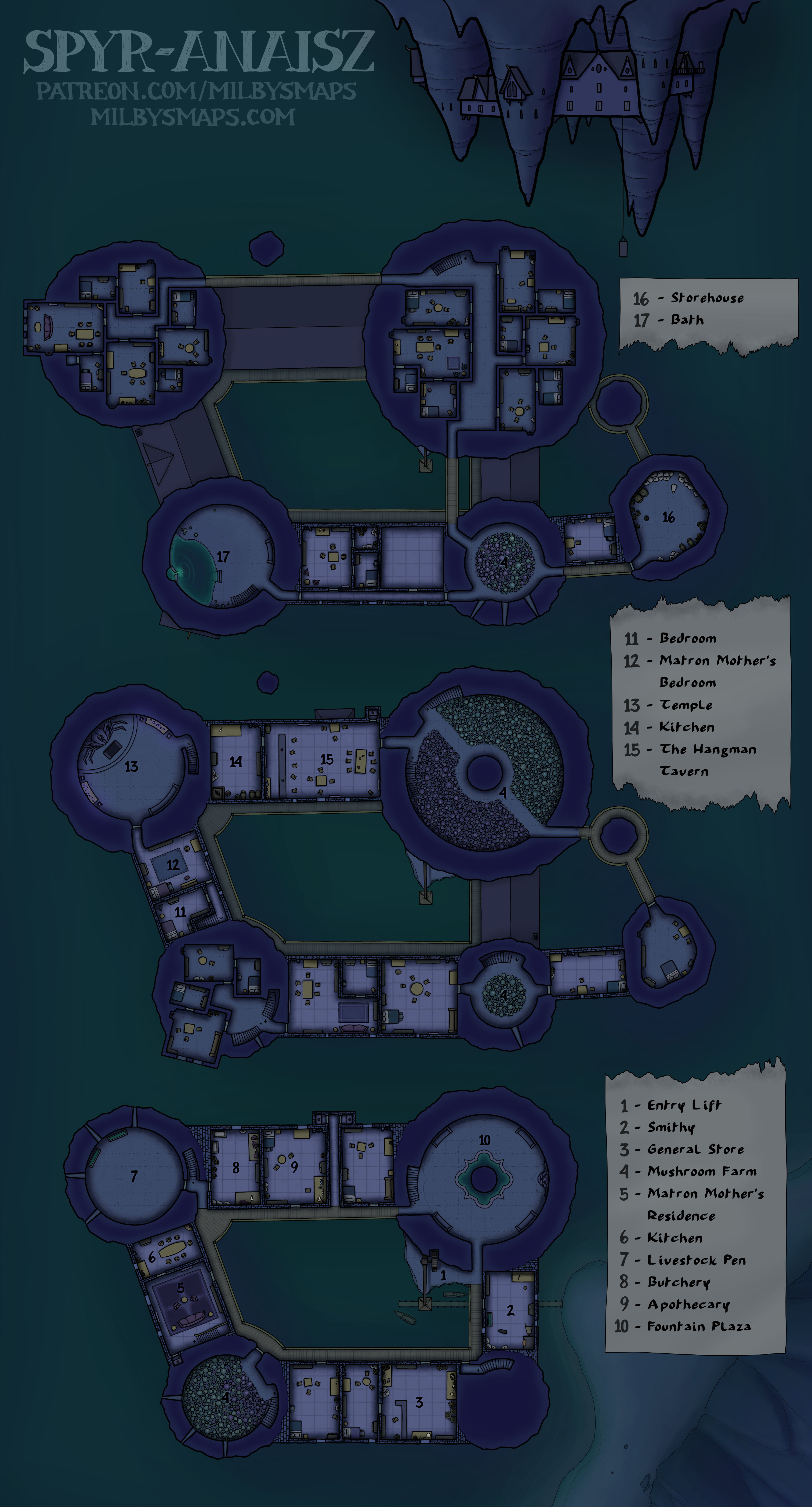
The Village of Spyr-Anaisz

Here’s the non-annotated version of the map.

Spyr-Anaisz is a small drow village in the Black Loch. The residents here aren’t big city drow, they’re rural drow. Drow hillbillies, if you will.

I don’t picture them chewing tobacco or wearing cowboy hats, but I imagine there’s a different sort of culture here. A bit less backstabbing and cutting throats to get ahead. Not much infighting among the nobility, since there’s only one noble house. And I think the city drow would probably look down on them, as inferior drow from an inferior place.

With an economy based around fishing and mushroom farming, Spyr-Anaisz isn’t a particularly wealthy community, but they are a fairly safe one. Built in and around a cluster of giant stalactites, the village hangs 80′ (25m) above the ground, making the list of dangerous creatures the people of Spyr-Anaisz have to worry about quite a bit shorter than it would be if they lived down below with everyone else. It isn’t the most convenient living arrangement, but sometimes convenience has to come second to security. Especially in the Underdark.

Next up, I’ll be drawing last month’s Cartographic Congress winner. This will be a multi-level village built in and around the branches and trunk of a giant tree, with bridges running between the buildings. I haven’t drawn a map like this in ages and I’m really glad to get another chance.

It’s not the first map of a tree village anyone’s ever made, but I think it’ll be a pretty unique take on the idea. I’ve got a lot of ideas about it swimming around in my head right now and I really want to start sketching things out and see how they look on paper. I think I’m gonna get started on that now.

Well, I hope you like Spyr-Anaisz. Let me know what you think!

The Town of Five Arches

Here’s the non-annotated version.

Five Arches might seem like a place you’d only find in the realms of fantasy, but you’d actually find something fairly similar in the realms of Italy– namely, the Ponte Vecchio in Florence. And there’s another bridge like this in Germany called the Krämerbrücke, as well as one in England called Pulteney Bridge. This map was heavily inspired by all three.

I think Five Arches would make a pretty interesting location for a “please sir, take back our town from the green people” type of adventure. It’s not the most original premise, but I think a unique setting can make that kind of adventure much more interesting. And those kinds of classic scenarios are the bread and butter of a lot of FRPGs. Most of us can’t reinvent the wheel every week.

Next up, I’ll be drawing Scotland’s 28th most famous castle, Coxton Tower. It’s not huge or epic, but it’s an interesting place with some distinctive character and I think it would suit a lot of encounters nicely. “Useful but unique” is one of the main things I aim for with my maps and I think Coxton Tower fits that description very well.

By the way, I’ve decided that the next historical map will be from India. I don’t know specifically what I’ll be drawing, but I decided on India for two reasons:

  1. There are some incredibly cool places in India.
  2. It’s India’s turn. I mean, it’s been India’s turn. They built this, this, that, this place, one of these and this thing and they still can’t get a fantasy map? At this point, I think they’re due.

Anyway, I’ve been looking over my options, but if you have any suggestions, by all means let me know in the comments (if you’re not a patron, you can leave a comment on my website).

Well, Five Arches was a bigger project than I thought, but it turned out exactly how I’d imagined it and I hope you like it too. Let me know what you think!

The Flying Rook

Here’s the annotated version and here’s the unfurnished version.

The Flying Rook is the sort of place wizards build to show off. Anyone with the power to keep this architectural Frankenstein standing is no joke, but– just in case anyone wasn’t fully convinced– they made it fly as well.

I didn’t have any particular purpose in mind when I added the windmill, but, the more I think about it, the more I’m wondering– and hear me out here– what if it was a propeller? Like, what if this whole thing was kind of an airship? That’s not for everybody’s game, of course, but it’s an idea you could roll around in your head if you want to do something a little different.

So, now that we’ve got that 13-story building taken care of, I’ll be moving on to something considerably bigger. Naturally.

As I mentioned before, I’ll be drawing Fort Bourtange, a magnificent 16th century grapeshot dispensary star fort in the Netherlands. It’s a big place, but I believe it’s all one level, so it shouldn’t take an unreasonable amount of time. I think I might get it done by the end of the month, but I don’t want to make any promises.

I’ll be making an unfurnished version of the map as well so you can use it as a village instead of a fort if you prefer. And it actually was a village for a few centuries, so that’s not a stretch.

Well, I’ve been champing at the bit to get started on this map for a couple months now, so I think I’m gonna go do that. Let me know what you think of the Rook!

There are DM notes for this map available to patrons.

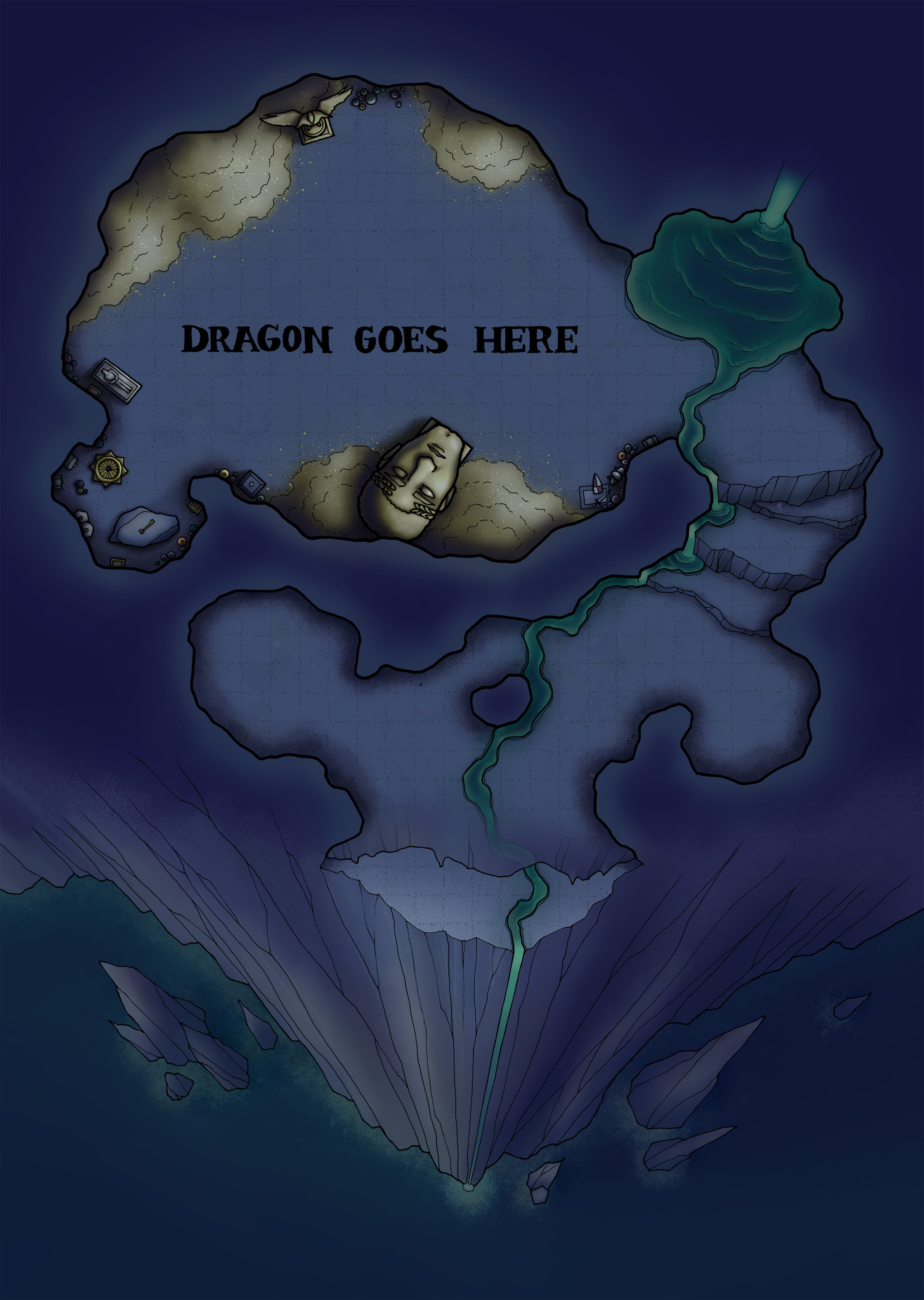
The Lair of Kaliphex

In case anyone is having a hard time understanding this complex labyrinth of a map, I made an annotated version to break it down for you. Hopefully that clears everything up.

There’s an unfurnished version, too, in case you need a cave without a giant, golden head and huge piles of cash. I suspect your players will prefer the one with the money, but it’s up to you.

So, the Lair of Kaliphex is a part of the Black Loch and is home to the resident dragon. Patrons can read about her in the DM notes, but here are the important parts:

  1. Kaliphex is a red dragon.
  2. She’s around 11,000 years old. Even for a dragon, that’s ridiculously old.
  3. She’s not evil. She’s not good, either, but she’s killed and destroyed so much that it just doesn’t do anything for her anymore.
  4. She’s lived on a number of different worlds. The last one may have been the Old World, where the tabletop wargame Warhammer was set. And she maypossibly— own Ghal Maraz.

For those of you unfamiliar with Warhammer, Ghal Maraz is the specific warhammer from which the game gets its name. It was made by dwarves, wielded by a god and seemed like an appropriate thing for an 11,000-year-old dragon to have.

In case you’re wondering, I do play Warhammer. My army is mixed Destruction and it’s pretty weird. The general is an ogre on a pink stonehorn. I’ve also got some orc cavalry whose armor is painted with elaborate heraldry like Brettonian knights. I call them the “High Orc Noble Cavalry.” And then there’s Pamela the Devourer, a colossal squig wearing way too much makeup and crashing through a wall like a demented Kool-Aid man. I want to be clear that no part of that last sentence was a joke or an exaggeration. I paint some weird stuff.

I also play Warhammer 40K, for which I have a Tyranid army. I mainly play Tyranids because I like the models, but it’s also nice to be on the team that’s winning. I haven’t actually played in quite a while, but I’m looking forward to meeting up with a friend for a game as soon as the Warhammer store re-opens. He’s probably reading this and, yes, I mean you. I haven’t forgotten.

Next, I’m going to be drawing a spelljammer. I drew a mind flayer dreadnought a few months ago, but this is going to be a more reasonable-sized vessel. Something for the party to cruise around in. Spelljammer is the one setting where people are still using maps from 1995 and I think it’d be good to get a proper map out there for DMs running their games offworld. I’m not sure exactly what kind of ship design I’ll be doing, but it’s not going to be the kind that just looks like a boat.

Well, I’m gonna go look at some spelljammers. If you’ve got any suggestions, let me know!

Glogdolp: A Kuo-Toa Village

Here’s the annotated version.

Glogdolp is a kuo-toa village in the Black Loch. The main things they do here are mollusk farming and slaving. That big jail isn’t there to deal with widespread naughtiness.

Glogdolp is at the tail end of a larger kuo-toan nation called the Bluescale Empire, which stretches down the river to the south. They don’t have much of a presence in the Loch at the moment, but they have plans to change that. Those plans aren’t really happening in Glogdolp, but when we get to the nearby kuo-toa stronghold, you’ll get a look at the kind of nonsense they have in mind.

Basically, it’s crabs. Huge crabs. Like, stupidly huge crabs. Siege crabs. The Bluescale Empire is secretly breeding them and, at some point, they intend to use them to take over the loch.

Personally, I think Glogdolp would be a good place for a rescue mission. The kind that starts with a few potions of water breathing, so the party can sneak in through the underwater caverns. Or you could even have the party stop here to ask about something, then have them happen to see a bunch of slaves getting led into the cells. You know, start pushing some emotional buttons, get an argument going between the paladin and the rogue. We have to save them! We totally don’t. My god says we do! I don’t care about your god. You did when he was curing your Thayvian Crotch Leprosy!

Next, I’m going to draw a roof-level map of Glogdolp, which should only take a day or two. After that, I’m going to draw some tokens. Specifically, I’m going to make tokens pertaining to the Black Loch. So, kuo-toa, Lim the Ogre,  the orogs and drow of the Deep Spire, and so forth. If I’m going to draw all the places in the Black Loch, I might as well draw the people as well. That shouldn’t take long either.

By the way, if you don’t know about the tokens I made, there are around 270 of them and they’re free. You can download them all here.

Anyway, I hope you like the map! Let me know what you think of the Black Loch so far!

There are DM notes for this map available to patrons.

The Chesterboro Arms – Lim the Ogre, Proprietor

Here’s the non-annotated version and here are the DM notes. This map is a part of the Black Loch.

The Chesterboro Arms is a straight up dump. Nobody thinks they’d ever stay at a place like the Chester, but then they find themselves in a REALLY scary part of the underdark. Wherever you look, there are bandits, monsters and all kinds of awful crap that wants to kill you. You probably shouldn’t even be there and you’re damn sure not sleeping there, so you press on. And you keep pressing on. And after a couple days of walking, you’d give anything just for a nap.

And then you see it: the Chesterboro Inn. Is the food good? You don’t care. Have the beds ever been washed? You don’t care. Is it safe to sleep here? Well, the innkeeper is the biggest ogre you’ve ever seen, so… yeah, probably. And, sure, the building looks like it’s going to collapse, but what are the odds that it happens today?

If you have questions about the Chesterboro Arms, you should understand that you’re supposed to have questions. I didn’t just set out to make this place crappy, I wanted it to be hilariously crappy. The outhouse is huge. You have to go through a bedroom to get to the storeroom. There’s a shed full of chairs. I don’t really have an explanation for that stuff, except that they seemed like things Lim the Ogre would do. Speaking of which, if you want to know the story of how an ogre opens an inn, that’s in the DM notes.

I’m going to draw another Black Loch map next, maybe the kuo-toa village. After that, I’ll do something other than the loch. You know, mix it up a bit. Anyway, I hope you like the Chesterboro! If your party ends up going there, please tell me how it went. I seriously want to know.