The Brass Koi: Spelljammer Version

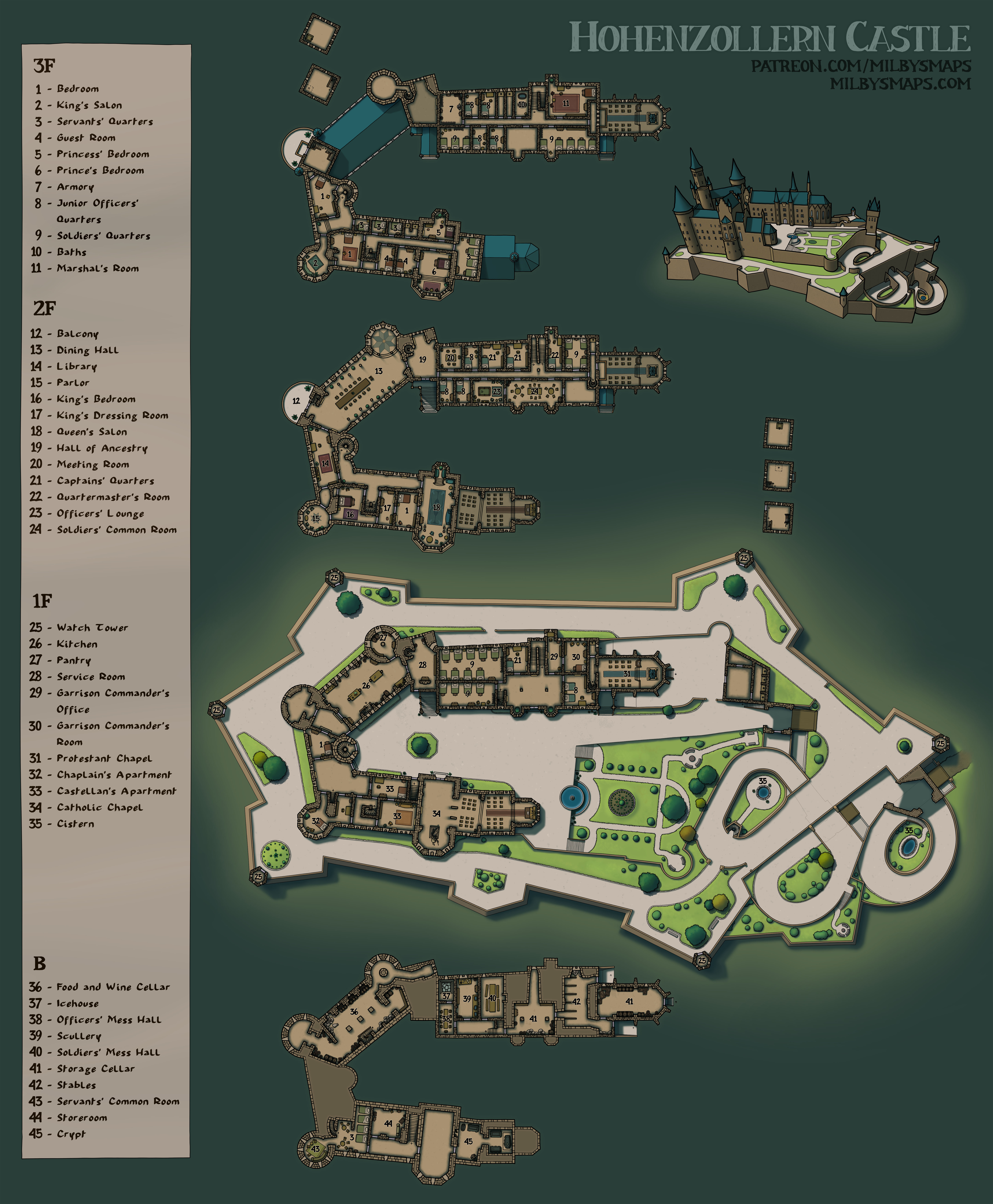
As promised, here’s the spacefaring version of the Brass Koi submarine. I don’t know how many Spelljammer DMs were specifically looking for an amphibious ship, but it does open up a few interesting possibilities. And, in any case, it’s another spelljammer map, which there still aren’t a ton of out there. It’s unfortunate that Spelljammer gets so little support in terms of maps, but I’m trying to do my part.

One thing I wanted to say about this version is that the engines and propeller are only used for underwater propulsion and wouldn’t be necessary for space travel. Now that I think about it, would they be necessary underwater? Could a spelljamming helm drive the ship underwater as well? I’m not sure, but maybe. I’m going with a definite maybe on this one. If you know your Spelljammer physics better than I do, let me know.

Next I’ll be drawing another map from Tir Thelandira. We’ve got 4 left to go, including two which patrons will be deciding on. Which reminds me, if you’re a patron, the vote is open on location #3, so cast a vote and tell me what you’d like to see there. I’ll be drawing the Dhasran colony next, which is a small mining colony that’s producing absurd amounts of gold. It’ll include the colony itself as well as the mines.

Anyway, I think that’s it for now. I hope everybody who was asking for a submarine is happy with the Brass Koi. Let me know what you think!

The Brass Koi

When I first started drawing this map, I was trying to avoid making it look too modern, since most people are probably going to use it in a fantasy setting. Then I saw a picture of a fighter jet and I thought about how cool a canopy like that would look on a submarine, so I drew one in. I still think it’s within the realm of “something a gnomish inventor might build,” but I apologize if I went too far. You’ve gotta admit, though– that canopy is pretty sweet.

I’m giving out the annotated version of the map to everyone so I can explain the various parts of the sub, since not everyone knows how a submarine works. Let’s start with the ballast tanks (5). In order to make the sub dive, you have to make it heavier. You do this by opening the ballast tanks to fill them with water. To ascend, you force the water out with air tanks and pumps (6, 11). This is how you control the depth of the submarine.

If your party has a submarine, they probably need to be able to get out of it underwater. That’s what the lockout chamber (16) is for. You enter from the top, seal it shut, then open the door to the outside. The lockout fills with water, but the rest of the sub doesn’t.

And then there’s the light (3). Gnomish inventors probably aren’t building you a sonar system, so you’re piloting this thing the old-fashioned way. And since it’s dark underwater, you need a lamp. The Koi has a lamp and reflector in the bow so you can avoid crashing into rocks or running over any passing kuo-toa. Or maybe you want to splatter the kuo-toa. It’s up to you, but you need to be able to see them either way.

I hope that helps everyone understand the map a little better. As I said before, I’m going to make a spelljammer version of this map as well. You know, the more I think about it, the more I like the idea of an amphibious spelljammer. Anyway, I’ll have that for you tomorrow. Until then!

The Tower of the Moon

The elves of Tir Thelandira don’t know much about arcane magic. The magic that priests and druids can do? They understand that just fine. Basically, god does magic for you*. Simple. But wizard magic is something they don’t understand. And if you don’t understand it, you can’t teach it. And, in a society that can’t teach magic, there’s only one type of mage that can exist: wild mages.

A wild mage named Selaira lives here. She wasn’t the first to be born with an innate gift for magic, but she’s the first to really investigate it, to try to learn how it works. She’s the first to do experiments and write books about her findings. At the moment, she’s teaching other wild mages to better harness their abilities, but she’s starting to suspect that she can teach magic to people without an innate gift. If she figures that out, magic might go from being a rare gift to a widespread ability that affects every part of society.

Considering the major role that magic plays in other elven societies, this is a bit like peanut butter being mere moments away from the discovery of jelly. A very exciting moment in history, to say the least.

Next, I’ll be drawing the Chateau D’If. This is a 16th century island prison just south of France. Part of the book The Count of Monte Cristo takes place there. I’ll be drawing it as best I can with the limited amount of reference material available. Which is to say, I can’t find a proper floor plan, so I’m going to have to make some stuff up. Still, I think it’ll make a great map.

Anyway, I’m gonna get to work on Classy French Alcatraz. Let me know what you think of the map!

*I know this isn’t how everyone interprets it, but that’s how it works in my games.

Auld Mithrilsides: A Dwarven Sternwheeled Steamship

This was intended to be the ship from Thanesridge Landing. But that ship was crap, so I redrew it. I like this much better. I will always redraw and rework a map rather than knowingly put out something that sucks, even if it takes a bit longer. Also, I’m going to replace the ship in Thanesridge with this one, but give me till tomorrow to get that done.

So, the map. Dwarves aren’t known for their love of ships, but I felt like this is the kind of ship a dwarf would build. With a coal-fired steam boiler for propulsion, they don’t have to worry about “learning to sail” or whatever. Just fuel it up and point it where you want to go. Which way is the wind blowing? Who cares. Plus, the burning coal makes it smell a bit like home.

I’d like to remind any DMs considering using this map that the ship’s speed is entirely dependent on how hot the boiler can get. So if the party starts summoning fire elementals in the fuelbox, things could get pretty interesting. Of course, the ship is made mostly of wood, so hopefully they don’t get too interesting. Anyway, something to think about.

Next up, I’ll be drawing the next map for Tir Thelandira. This will be the map proposed by Shawn and voted for by patrons. It’s called the Tower of the Moon and I’m imagining it like this: a round, wooden tower that snakes upward, curving and branching off in a few places. It’ll be kind of like a large, hollow tree. I haven’t drawn it yet, but it looks really good in my head.

Anyway, I think that’s it. Let me know what you think of the ship!


Hohenzollern Castle

Here’s the annotated version. No reason both of us should have to type a bunch of text from old, German maps into Google Translate.

I’ve had a few people working on academic papers message me about my historical maps and I want to make something clear for anyone who googled their way here: FOR THE LOVE OF GOD, DO NOT USE MY MAPS AS REFERENCE FOR ACADEMIC RESEARCH. If you can’t find a complete, contemporary floor plan, I probably didn’t either. And– this is important– I’M ALLOWED TO FILL IN THE GAPS BY MAKING STUFF UP. The idea that I might inadvertently rewrite history by making D&D maps is slightly hilarious, but ultimately something to avoid.

*ahem*

With that out of the way, Hohenzollern Castle, in Baden-Württemberg, Germany, was the ancestral seat of the Hohenzollern Dynasty. The Hohzenzollerns were the rulers of Prussia and, later, Germany. They also produced some of the most potent mustaches in Central Europe. Without getting too far into it, let’s just say things went well for the Hohenzollerns right up until they didn’t.

This map turned out to be a ton of work, but I hope you like it. Next, I’ll be drawing the map chosen by the last Cartographic Congress: a small, fortified dwarven port town. Erik, who proposed the idea, plans to use it as a part of Brazenthrone, so I guess you could consider this an unofficial expansion of the dwarven city.

Okay, that’s it. I’d love to hear what you think of Hohenzollern Castle!

The Blackboots’ Camp

This is the encampment of the Blackboots mercenary company in Tir Thelandira. The Blackboots are from all over the place. so the camp is filled with tents from all over the place. You’ve got ridge tents, pup tents, tipis, a marquee and, of course, yurts. If tents had a hierarchy, yurts would be the king.

The Blackboots are meant to be everything Glaver’s Regiment isn’t. They’re a cavalry company made up largely of former bandits, known for their dubious loyalty and their habit of killing more civilians than enemy soldiers. Hired after the wood elves destroyed the first human colony, the Blackboots are in Tir Thelandira to commit atrocities and read poetry. And they don’t know how to read.

The next map is something I’ve been asked to draw by several people over the years. I told them it wasn’t time. It’s time. I’m drawing Hohenzollern Castle. Strap on your spikiest helmet, things are about to get Prussian.

Laon, France

I don’t draw a ton of city maps and this is the first one that I’m really happy with. Hopefully you like it too, or at least agree that it’s less crap than usual.

Laon has been around for a long time and, if you’re going to draw a map of it, you have to pick a specific point in time to depict. Well, in theory you do. I didn’t. I used several maps from various points in time as reference and, as a result, this is a sort of mash-up of several centuries of the city’s history. I don’t think that’ll be a problem for most people, but, you know, don’t use this in your Master’s thesis on the history of the Kingdom of West Francia.

Next, I’ll be drawing another map for Tir Thelandira. This time, it’ll be the Blackboots camp. The Blackboots are a mercenary company with a nasty reputation and they’re basically the other side of the coin from Glaver’s Regiment. Whereas Glaver’s Regiment is well-organized, professional and honorable, the Blackboots are filthy, drunk and cruel.

I don’t know exactly what the Blackboots camp will look like, but I can tell you two things right now:

  1. There will be yurts
  2. You can probably use it as an orc village if you want

After that, I’ll probably draw whichever map wins the vote for Tir Thelandira’s location #1. If you’re a patron and you haven’t voted in the runoff, go do that.

Anyway, I hope you like the map! Also, does Laon look like the Italian Peninsula to anyone else? I just noticed it. The bottom-left part is Sicily, tell me I’m not crazy.

Glaver’s Regiment

So, let me start by acknowledging that Glaver’s Regiment is maybe a little small for a regiment. It’s really more like Glaver’s Company. I hadn’t realized that until I counted the beds and realized that there’s only space for about 127 soldiers here. Let’s chalk it up to attrition.

This map was inspired by the marching camps of Roman legions, who would build a defensive stockade and dig a ditch around it whenever they made camp for the night. They were able to get this done in a few hours by bringing the wooden stakes for the walls wherever they went.

There are actually a few of these around today. Well, kind of. You see, when a legion stayed in one place for a while, they would reinforce their camp. Build towers, reinforce wood with stone, replace tents with buildings and so on. Some of those are still standing.

A few European cities actually originated as Roman forts or “castra.” Castres in France is one example, as is any place in the UK with a name ending in -caster, -cester or -chester. There are quite a few of those, which suggests that the English were a fairly rowdy bunch in the ancient times. And the Great Wall of Scotland tells you everything you need to know about Rome’s issues with the folks to the north.

Next, I’ll be drawing a city map based on a real place: Laon, France. It’s a walled town with a cathedral, a palace and a templar church. Here’s a photo. It’s a classy place and I think it’ll fit right into a fantasy setting. After that, I’ll be back to work on Tir Thelandira.

Well, that’s it for now. Let me know what you think of the map!

The Ruins of Giltwater

Giltwater is the first Dhasran gold mining colony in Tir Thelandira, marked as “Burned Colony” on this map.

When I finished drawing this, I read back through the lore of Tir Thelandira and realized I’d made a mistake. In the lore, I said that hundreds were killed when the elves attacked Giltwater. But I hadn’t drawn a colony big enough to hold hundreds of people. So what did I do? I did what anyone writing fantasy roleplaying game lore would do. I retconned it. I retconned the absolute living hell out of it.

I think the lore will have to stay a little flexible until the island is done, particularly since there are three locations that haven’t been decided on yet, which makes them hard to plan for. Speaking of which, if you’re a patron and you haven’t cast a vote on the second ballot for location #1, you’ve got one more day to do that.

So, what’s next? Well, I’m sick at the moment and I don’t have it in me to start on a new map today, so I’m going to give myself something easy to do. Tir Thelandira is going to be part of a larger world with many more islands and I want to start laying out that larger world so we can start thinking about where we go once this first island is done. I feel like I’m up to that. I can draw a collection of variously-sized blobs. I believe in me.

I should have that done tomorrow and you can tell me your thoughts about it. After that, I’ll get started on another map for Tir Thelandira. Okay. Time for blobs.

Ptarmigan Bluff: A Mining Village on a Cliffside

First of all, this is what a ptarmigan is. They live in the mountains. The “P” is silent, but is included in the spelling because the English language is designed to inhibit the spread of literacy at all costs.

I really like the idea of a village built against a cliff, but drawing one turned out to be a lot harder than I expected. Still, I do like a challenge and I think I’m happy with it. The hard part was putting this all together in a way that makes sense.

You see, drawing a five-story building is one thing. But drawing 10 different buildings with five floors among them, all tied together with stairs, walkways and bridges… well, that’s a little more complicated. I numbered the buildings on the sideview to indicate which buildings are on which levels and I hope that’ll make it easier to understand. But if you’ve got any questions, by all means ask.

Next, I’ll be drawing another map for Tir Thelandira. Specifically, I’m going to draw the ruins of the burned mining colony. You can see a list of what’s left to draw in this post.

Speaking of Tir Thelandira, the poll for the first of three undecided locations is still open for patrons who want to cast a vote. Since there were 21 ideas submitted for the first location, I’m dividing them up into three votes of 7, then holding a runoff for the winners to determine what the location will be. I’ll start the vote for the second group of 7 in a day or two.

Well, that’s it for now. If you’ve got any thoughts, let me know!