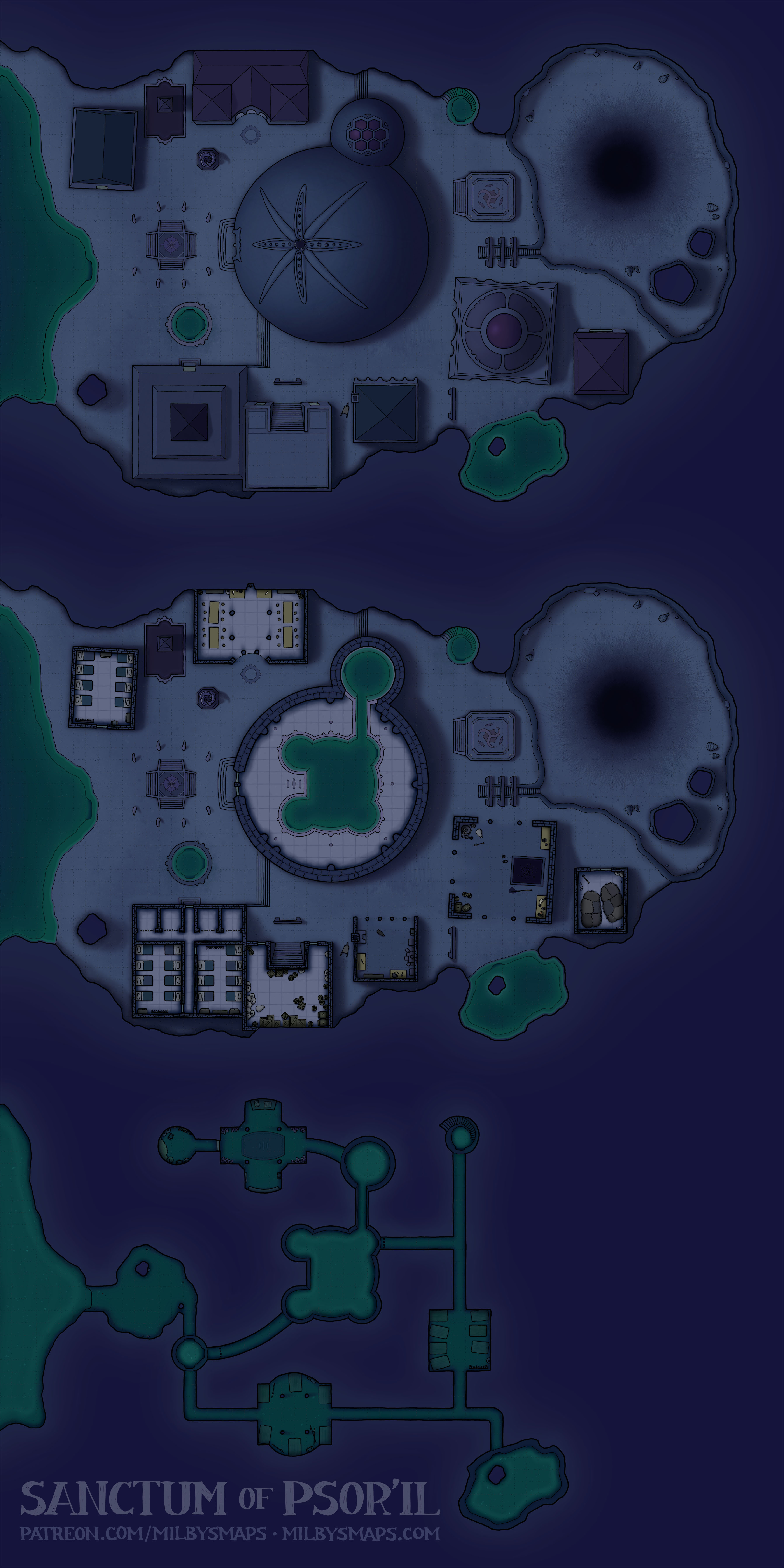
The Green Eye Oasis

The Green Eye is a village and caravanserai built around a small oasis in a sinkhole. The place has everything a traveling merchant needs: camel parking, a room for the night, baths, a tavern and a provisioner. Oh, and water. Merchants need that to live. I mean, everybody does, but merchants do too.

I think this would be a really great place for a battle, especially if the party was inside the village while getting attacked by archers around the edges of the sinkhole. That’d create a really nasty situation, since the place is kind of… what’s the word? The opposite of defensible. It’s an easy place to attack. Making the party fight their way out of here could be an interesting challenge.

Next, I’ll be getting to work on the second map for Tir Thelandira. I’ve got a few different maps planned for the island, but I really want to draw Oakenhold next. Oakenhold is a giant tree fortress which serves as the wild elves’ capital. This will be the first time I’ve ever redrawn a map. If you want to get an idea of what it’ll look like, here’s the original. I’m fairly confident that the new version will be better than that. It certainly won’t be in black and white, anyway. I’ll also write some lore for Tir Thelandira to go along with it and I’ll make some more concrete plans for the rest of the island as well.

All right, hope that sounds good to you! Let me know what you think of the oasis!

The Generalife: A Palace of the Alhambra

I visited the Alhambra a few years ago and, before I went, I was considering drawing a map of the place. When I got there, I realized how completely insane a task that would be. Here’s the entire Alhambra complex. This map– the Generalife– is the little thing in the top right. I’ve drawn a four-level map of Mont-St-Michel and I’m pretty sure the Alhambra would take longer than that did.

To give you an idea of how big this place is, there are six other palaces in the Alhambra. And if that sounds crazy, there used to be two more. If you plan to be in Spain, I highly recommend going to see it. There are a lot of castles in the world, but only a few of them will make your head literally, physically explode and this is one of them.

Next up, I’ll be drawing the Great Bombard spelljammer I promised a few months back. It’s basically an enormous cannon with a ship wrapped around it. You could call it the A-10 Warthog of spelljammers. I’ll make a seafaring version as well for those running monoplanetary campaigns.

After that, I’ll be drawing Akshardham Temple, a Hindu temple in New Delhi. When someone builds something that looks this good from the top down, I basically have to make a map of it.

Okay, that’s it for now. I hope you like the map! Let me know what you think.

The Black Loch is Finished.

I’m giving away the Patrons’ Edition stuff for this map to everyone. You can download it all here. When I drew those cave and tunnel maps earlier, I was thinking about giving those away, but I decided I should give you a good map instead. So here it is.

With Charwall finished, the Black Loch is finally done after a year and a half. It’s been a huge amount of work drawing around 30 maps and 100 tokens and writing lore for it all, but I feel pretty good about it and I hope you like how it all turned out.

I want to say that I’m truly grateful to all the patrons who have supported this along the way. It felt like an incredible honor to be given the ability to spend two years drawing Brazenthrone and it’s no less an honor to have been able to put another year and a half into making the Black Loch as well.

Moreover, I’m grateful to be able to have your support for this despite the fact that I’ve given away usable versions of all the maps for free. I’m fairly sure that costs me money. I have no idea how much, but my rent gets paid and I’m not going to stop doing it. I feel very fortunate not to have to.

Well, it’s 9am and I’ve been up all night, but let me mention a few things before I go. I’ve updated the Black Loch Codex and the History and Lore Overview with Charwall. Remember when I made a post titled “The Black Loch: History and Lore Overview – FINAL UPDATE FOR REAL THIS TIME“? Okay, that was a lie, but this is the final update for real. Like, really real. Actually, legitimately very real. Anyway, it’s in the codex and you can download the new version here.

Well, that’s it for now. It’s been quite a journey and I hope you like where it all went. I’ve got another one in mind and I’ll tell you all about it in a day or two. Until then!

The Sanctum of Psor’il

Here’s an alternate version without the worm.

For a number of reasons, I don’t draw monsters in maps. It might look like that’s what I did here, but… it is and isn’t a monster. Allow me to explain. Psor’il, the aboleth who resides here, is trying to bring a creature from a bizarre, hostile dimension into the Black Loch.

To allow it to cross over, the aboleth’s minions are making a substance called “schismic flux,” which weakens the barrier between dimensions. They’ve weakened it quite a bit, but not enough for the creature to pass through. So, at the moment, the creature is stuck in between planes. And it’s visible in this world, but it’s not tangible yet. In other words, the monster is scenery. Weird, scary scenery, but not a monster. Yet.

I’m very curious what your opinions on it are. I was trying to make this place as strange as possible and that was one of the things I came up with. I also made a version without the worm in case anyone objects.

Next, I’ll be drawing the map chosen by last month’s Cartographic Congress: a sewer system with tunnels that cut through ancient, dwarven ruins, leading deep into the earth. After that, I’ll be back to the Black Loch to draw one of the last 3 locations.

Anyway, I’d love to know what you think about the map. And I know it’s kind of a strange one, so if you’ve got any questions, feel free to ask!

Elderseed Sanctuary

Elderseed Sanctuary is a small treehouse settlement in a giant baobab. I designed it with a druid community in mind, but it could easily be a village of wild elves as well. Or aarakocra. Or avariel. Or weresquirrels.

Here’s a question to think about: is it a treant? If so, that makes this place mobile, which allows for some interesting possibilities. For example, your party could make camp in the woods and wake up next to this thing. That could be a handy approach if your party isn’t great at following a trail of breadcrumbs to the next adventure. Just park the next adventure on top of all their stuff and see if they can work out what to do.

Next up, I’ll be drawing another map from the Black Loch. This time, it’ll be the ancient crypt on Cairnhollow Isle. I’m not sure exactly what I’m doing with it, but I think it’ll be a fairly decrepit series of winding tunnels and catacombs, leading to a huge, elaborate burial chamber at the end. I’ve got a bunch of maps of the Paris Catacombs, so hopefully I can give the map a fairly authentic feel.

Well, that’s it for now. Let me know what you think about the map!

Whaleship-Class Spelljammer

The whaleship is a spelljammer for people who want to go to space, but don’t want to leave anything behind. ANYTHING. Not the billiard table, the pool, the tavern, or anyone they know. It’s all coming. Hell, bring the whole village. It’s fine, there’s room for everybody, sheep included.

The whaleship is designed as a passenger liner and cargo ship, but some DMs may want to use it as a player vessel, so I included a few versions of the ship retrofitted with weapons. Here’s the lightly-armed version and here’s the heavily-armed version (aka “the Whalehammer 40K”). Also, here’s a token of the ship.

Next, I’ll be going back to the Black Loch and drawing the drow settlement. After that, I’ll be drawing last month’s Cartographic Congress winner, “a multi-level village built in and around the branches and trunk of a giant tree, with the buildings of the village connected by bridges.” After that, I’ll probably be working on the Black Loch for the rest of the month.

All right, I’m gonna get some sleep. Let me know what you think of the whaleship!

The Roost

This is the map chosen by patrons in the Black Loch Conclave: a drow outpost in the roof of the Black Loch. This map is complicated to say the least, so let me break it down for everyone.

The Black Loch is a small sea in the underdark. There’s a large hole in the roof of the loch’s cavern, leading up to a sea on the surface. The hole, known as the Great Breach, is about 100 meters wide, with water constantly pouring down the sides.

The falling water does not fill the breach completely, however. There is enough space for an airship pilot– a talented airship pilot– to maneuver a vessel down the center. Not many places in the underdark are accessible by airship, but the Black Loch, very unusually, is.

So, this map is a surveillance outpost located at the bottom edge of the Great Breach. It’s used by the drow to track the comings and goings of airships. The drow also have a hangar here, in which they keep their own airship, known as the Duskfall.

TL;DR: It’s a spy outpost at the bottom of a giant waterfall in the underdark, where the drow keep their airship. I hope that doesn’t sound as insane to you as it does to me.

Anyway, you may have noticed that this map has a map of an airship inside it. I’m going to take a day or two to make a separate map of the airship next. You may need it if you bring your players here, because, let’s be honest: they’re going to steal it. Seriously, no matter who your players are or what kind of game you’re running, your party has a one hundred percent chance of stealing that airship, or at least trying to. I honestly can’t imagine a party that wouldn’t. Still, if that’s a problem for you, it can always be a broken airship.

Well, that’s about it. Out of twenty ideas for a new location in the Black Loch, this is the one you chose. I hope you all like what I did with it. Anyway, let me know what you think!

The Citadel of Ash

A lot of people will look at this map and see a place inhabited by one of two things:

  1. Bad guys
  2. Dwarves

Why? It’s the lava, of course. Lava in FRPGs is practically code for dwarves and scumbags. It’s almost like decent, respectable humans can’t recognize the defensive utility of molten rock.

Hopefully, this isn’t how it works in real life, because I recognize the defensive utility of molten rock. And I’m a little too tall to be a dwarf.

Anyway, the first vote of the Black Loch Conclave started yesterday and, if you’re a patron, you should go cast a vote. There are some amazing ideas people have proposed for this and I really want to see what everyone decides on. Honestly, there are a few proposals that have inspired me so much that I’m thinking of incorporating some of their ideas into other maps if they don’t win. I am so glad I did this.

Next up, I’ll be drawing the Kuo-Toa Stronghold from the Black Loch. Like the Mother’s Eye, it’s going to be partially underwater. I don’t think I’ve seen a map of a semi-submerged castle before, so this should be fairly unique, or at least not something there are a million of out there. And, once it’s done, I should have time to knock out another one or two Black Loch maps this month.

Anyway, I’m gonna get to work. Let me know what you think of the Citadel!

The Ruins of Gyan’dis

Here’s the unfurnished version.

Gyan’dis is a ruined illithid settlement in the Black Loch. The colony thrived in its corner of the loch for over 800 years, until it was brought down and its inhabitants wiped out by Gyan’dis’ own elder brain. Normally, I’d talk a little more about the background of the map, but I’m going to leave that for a day or so, because I’m planning on writing up an overview of the history and lore of the Black Loch, which I can probably get done sometime tomorrow.

It’ll have basic information on the loch, along with brief summaries of the locations I’ve drawn so far. I think it’ll be a good introductory overview of the setting, which should be useful to patrons and non-patrons alike. Also, for non-patrons, I promise it’ll explain more about why the elder brain destroyed its own colony. I wouldn’t leave you hanging like that.

Once that’s done, I’ll be getting started on last month’s Cartographic Congress winner, a town built on a bridge over a river canyon. I’ve been champing at the bit to get started on that and it’s taking all my willpower to write up the Black Loch overview first. But it’s long overdue, it needs to be done and it’s only a day’s work at most, so I’m just going to bite the bullet and get it written.

After the bridge, I’ll be drawing the next historical map, Scotland’s Coxton Tower. And then we’ll probably find our way back to the Underscotland for another piece of the Black Loch.

Sound like a plan? Either way, let me know what you think!

Ard Skellig

Here’s a map of the interiors of the buildings and here’s a map of just the island with nothing on it.

Of the many Irish isles, one would have stood out to ancient settlers as a particularly good place to live. With its rolling hills, thick forests and an abundance of arable land, it was exactly what many of them were looking for. The island was called “Ireland” and, conveniently, it was the big one in the middle.

But for some people, Ireland was a bit too easy. They were looking for a challenge. These people wanted to make their homes on a smaller island, several miles offshore. Maybe a steep, jagged rock jutting out of the sea, preferably with no trees, very little flat ground, and, of course, no farmable land. Because agriculture is basically cheating.

A little ways off Ireland’s southwest coast, they found exactly what they were looking for: Skellig Michael. They headed over, built themselves a few big, stone beehives to live in, and enjoyed spending the rest of their lives away from the fast-living, hectic lifestyle of rural Kerry.

Then, over 1000 years later, Luke Skywalker showed up. Seriously. If you recognize this place, that’s probably why. In 2015, part of Star Wars: The Force Awakens was filmed on Skellig Michael. And if the island’s name rings a bell, that’s probably because you’ve played the Witcher. The Kingdom of Skellige is named after it. I’m not sure how the producers of Star Wars or a Polish author even knew this place existed, but apparently it’s more famous than you’d expect.

Anyway, next, I’ll be drawing another map from the Black Loch. This time, I’ll be drawing the ruins of an Illithid settlement, which should be a pretty interesting place to explore. After that, I’m going to draw the map chosen by last month’s Cartographic Congress, which I am ridiculously excited about.

Once in a while, someone proposes something to the Cartographic Congress that’s very similar to an idea I’ve been wanting to draw for a while. And, once in a while, that proposal wins. This is that proposal: a town built on a bridge over a river canyon.

I’ve seen a couple maps based on similar ideas before, but I’ve got a whole different sort of thing planned. I’m planning to draw buildings along the sides of the bridge, plus a lower level underneath the bridge deck, and hollow spaces inside the support pylons. I want to have the settlement extend into the cliffsides beneath the bridge as well. I’ve got a big vision for this and I think it’s going to be really cool, either as a settlement or as a dungeon to explore.

Well, that’s it for now. Hope you like Ard Skellig. Let me know what you think!