Laon, France

I don’t draw a ton of city maps and this is the first one that I’m really happy with. Hopefully you like it too, or at least agree that it’s less crap than usual.

Laon has been around for a long time and, if you’re going to draw a map of it, you have to pick a specific point in time to depict. Well, in theory you do. I didn’t. I used several maps from various points in time as reference and, as a result, this is a sort of mash-up of several centuries of the city’s history. I don’t think that’ll be a problem for most people, but, you know, don’t use this in your Master’s thesis on the history of the Kingdom of West Francia.

Next, I’ll be drawing another map for Tir Thelandira. This time, it’ll be the Blackboots camp. The Blackboots are a mercenary company with a nasty reputation and they’re basically the other side of the coin from Glaver’s Regiment. Whereas Glaver’s Regiment is well-organized, professional and honorable, the Blackboots are filthy, drunk and cruel.

I don’t know exactly what the Blackboots camp will look like, but I can tell you two things right now:

  1. There will be yurts
  2. You can probably use it as an orc village if you want

After that, I’ll probably draw whichever map wins the vote for Tir Thelandira’s location #1. If you’re a patron and you haven’t voted in the runoff, go do that.

Anyway, I hope you like the map! Also, does Laon look like the Italian Peninsula to anyone else? I just noticed it. The bottom-left part is Sicily, tell me I’m not crazy.

Glaver’s Regiment

So, let me start by acknowledging that Glaver’s Regiment is maybe a little small for a regiment. It’s really more like Glaver’s Company. I hadn’t realized that until I counted the beds and realized that there’s only space for about 127 soldiers here. Let’s chalk it up to attrition.

This map was inspired by the marching camps of Roman legions, who would build a defensive stockade and dig a ditch around it whenever they made camp for the night. They were able to get this done in a few hours by bringing the wooden stakes for the walls wherever they went.

There are actually a few of these around today. Well, kind of. You see, when a legion stayed in one place for a while, they would reinforce their camp. Build towers, reinforce wood with stone, replace tents with buildings and so on. Some of those are still standing.

A few European cities actually originated as Roman forts or “castra.” Castres in France is one example, as is any place in the UK with a name ending in -caster, -cester or -chester. There are quite a few of those, which suggests that the English were a fairly rowdy bunch in the ancient times. And the Great Wall of Scotland tells you everything you need to know about Rome’s issues with the folks to the north.

Next, I’ll be drawing a city map based on a real place: Laon, France. It’s a walled town with a cathedral, a palace and a templar church. Here’s a photo. It’s a classy place and I think it’ll fit right into a fantasy setting. After that, I’ll be back to work on Tir Thelandira.

Well, that’s it for now. Let me know what you think of the map!

The Stonestead

The Stonestead is a broch. They’re a real thing and there are a bunch of them in Scotland. I drew this particular broch for the island of Tir Thelandira, whose wood elf inhabitants have a distinctly Celtic-flavored culture.

The Stonestead is the elves’ first foray into large-scale stone construction. Built to defend a gap between the northern and southern parts of their forest, it’s meant to ensure that, should the Dhasran colonists or their mercenaries decide to march on the elven lands, they have to either fight their way through the fort or venture into the woods, where they’ll be easy prey for elven archers and ambushers. Neither option is great– but, of course, that’s the idea.

I’ve received quite a few proposals for new locations for Tir Thelandira. If you’re a patron who’s got an idea you’d like me to add to the ballot, you’ve still got time to shoot me a message. Just to recap, the proposals are for either the location marked “1” on this map OR the swamp to the east of Oakenhold. I’ll be posting the first vote in a few days.

Next up is an East Asian-style village built into a cliffside. This picture should give you an idea of the sort of thing I’ll be drawing. Personally, I think that’s nuts. I mean, how is that a real place? What happened there? I don’t know, but I’m glad it did. Because that’s awesome.

Caergyd Point (Complete)

Since this is fairly big, here’s the cave and the castle separately.

I just have one piece of advice for any DM whose party takes up residence in this castle: that cave is not a safe place to dock a ship. It’s out of sight and it gives a group of thieves plenty of time to get it ready to sail without anyone seeing. So, if they don’t station a guard down there to watch it, have somebody steal it. Maybe one of the PCs wakes up in the middle of the night and sees their ship pulling out of the cave.

It doesn’t have to be more than a short encounter. You could give them enough time to grab their swords and leap for the mast as the ship is pulling away. I’m just saying, a completely unexpected, butt-naked pirate battle in the middle of the night sounds like some pretty good D&D to me. Worth considering, at least.

Next, I’ll be updating the Tir Thelandira map with all the locations I’ve got planned. I just want to give everybody a better idea of what the island is going to look like once it’s finished. I’ll post that tomorrow, along with a brief description of what I’m planning to do with each of the locations. After that, I’ll pick one and draw it. Okay, see you then!

Caergyd Point

Caergyd Point was inspired, in part, by Conwy Castle in Wales. “Caergyd” is my attempt at a made-up Welsh castle name. All I really know about Welsh is that there are several castles with names that start with “Caer” and that a lot of Welsh words have a Y in them. This is the culmination of those two pieces of knowledge. Hopefully it’s passable.

This map was largely designed to be an ideal castle for a party to buy or otherwise acquire. To that end, it’s got a lot of things a party would want in a castle: a smithy for repairing equipment, a laboratory/study for the wizard, a chapel for the cleric, a kennel for whatever filthy creature follows the ranger around, a secret room, a tavern, a trading post to unload loot, and several empty rooms for the party to do what they want with.

There’s one more part of this map to finish: the sea cave underneath. I decided to make it separate in order to keep the map from being too huge. It’s about half-finished already and I should have it up tomorrow.

There are only three things in the cave: a dungeon, storage space, and a parking spot for a ship. Still, for parties that do a lot of sailing, it’ll be pretty useful. Or if you want to use this place as a pirate fort. Or if you want to have the party storm the castle to kill the bad guy, but leave a way for them to escape. I guess it opens up a few options.

Anyway, I’m gonna wrap that last bit up. Let me know what you think!

Point Caergyd (Almost Done)

I’m almost finished coloring this and it should be done by tomorrow, but here’s a look at it anyway. I meant to post this a few days ago, but I got a new computer recently and it doesn’t have a slot for my camera’s memory card, so I decided I’d buy one the next day. But that was St. Patrick’s Day and, here on the Isle of Emeralds, the stores close for that. Then I realized that the mysterious hole in the side of my tablet was a card reader, so here’s the picture.

Anyway, I’m gonna finish this up and I’ll have it for you tomorrow.

The Elven Tree Fortress of Oakenhold

After an absolutely enormous amount of work, the new and highly improved Oakenhold is finished. Moreover, I’ve written the history and lore of the island of Tir Thelandira. The TL;DR is this:

The elves of Tir Thelandira were nomadic tribes, but giant bears appeared and a lady killed them, unifying the tribes and becoming the queen. Then, humans showed up to mine gold, which was fine because the elves were pretty cool people. But the humans started logging the forest and the elves killed them all because they’re not actually all that cool. Later, the humans came back. People are probably going to die soon.

That’s the gist of it, anyway. I like settings where there isn’t a clear bad guy and I tried to write it that way. I mean, the Dhasrans did intrude on the elves’ land, but they weren’t there for conquest. They just wanted gold, which the elves didn’t really care about. And yeah, they shouldn’t have logged the elves’ forest, but the when the elves responded by going full-on North Sentinel Island on them, that may have been a slight overreaction.

There are a lot of angles to see things from and different kinds of adventures to run here depending on how you want to present the situation. Or you could just ignore my story and do something else entirely. That’s frequently the best option.

Anyway, I’ll have an updated map of Tir Thelandira for everybody tomorrow, as well as DM notes for Oakenhold for patrons. After that, I’ll be working on the map chosen by last month’s Cartographic Congress. This will be a palace in a Venetian-style canal city, drawn in a gothic/dark fantasy style. Prepare your eyeliner.

So, what do you all think of the new Oakenhold? I certainly think it turned out better than the original version and I hope you agree (I mean, I really do. That’s not a high bar to jump over). Anyway, let me know what you think!

Frog’s Haven Crannog

In the last post, I talked about my plans for the first island of the as-yet-unnamed big project. There will be two civilizations living on the island, one of which will be a kingdom of wild elves.

Over the past century, the wild elves have been shifting from a tribal, nomadic society to a settled one. While the elves have become better at building large structures of timber and stone, their skills at architecture are still well behind those of other civilizations. To reflect this, many of the wild elves’ settlements will be inspired by Iron Age Celtic buildings from Ireland and Scotland. Here’s a breakdown of what I have in mind:

Crannog – A crannog is a man-made island with one or more houses on it. The island was often surrounded by a wooden palisade and had either a narrow causeway or a path of stepping stones leading to the shore. Crannogs were most common in Ireland and Scotland. Frog’s Haven will probably be the only one.

Broch – A broch is an old style of Scottish towerhouse, which looks like this. I think I’d draw this fairly similar to the one pictured, perhaps with some farmland around the walls. I’d also give it a slightly more elven, tribal look.

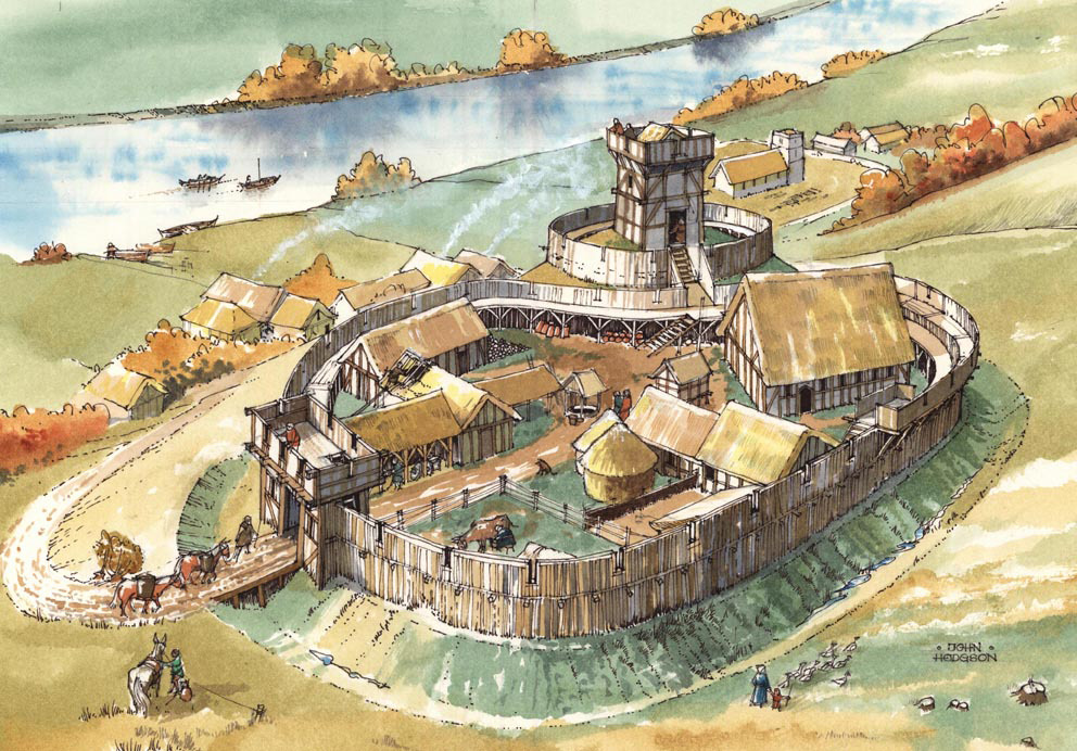
Motte and Bailey (or something similar) – A motte and bailey is an old style of wooden castle, which looks like this. I’d probably use a more elaborate version of the design and I’d make it more of a walled village rather than a fort. Again, it’d have an elven style to it as well.

OakenholdThis is one of the first maps I ever posted. I’ve never redrawn a map, but I want to redraw this one and I want it to be the seat of power for this wild elven civilization. I’ll change plenty about it, but it’ll be the same basic design. This is where the king or queen lives.

That’s the plan so far. There will probably be other locations as well, but I want to get your opinions on these ideas first. If the response is largely negative, I’ll come up with something else. If it’s positive, I’ll get started on a map of the island and we can start figuring out where things are and who the elves are sharing the island with.

Anyway, let me know what you think of the Celtic wild elves. Positive or negative, I really want to hear your opinions!

Murud-Janjira: An Island Fortress in Maharashtra, India

I made an annotated version of this map, which was only possible with the help of Aditya, who translated the only labeled map of this fort I was able to find, which was in Hindi. I’m very grateful for the help and the least I can do is pay it forward and give the annotated version away to everyone.

Murud-Janjira was built in the 1400s and was only taken by force once. The Maratha Empire assaulted it about a dozen times. They climbed the walls, they tried to dig their way in, they even built a fort nearby called Padmadurg to use as a staging ground for an attack. None of this succeeded. The Virgin Padmadurg was no match for the Chad Murud-Janjira.

So how was it taken? With booze. Let me explain. The fort was built by Ram Patil, the Admiral of the Ahmadnagar Sultanate. Once it was finished, Patil and the Sultan had a little falling out, Patil stopped taking the Sultan’s orders and they unfriended each other on facebook. The Sultan appointed a new admiral named Piram Khan and ordered him to take back the fort.

So Khan dresses up as a merchant and sails to the fort. He says he’d like to leave some crates of silks and wine inside for safekeeping. You know, temporarily. “Sure,” says Ram Patil, “You can leave your booze and loot with us. We’ll be happy to hang onto it for you. You know, temporarily.”

So they start bringing in the crates and Khan decides to throw a little party for Patil and his men for doing him this favor. At this point, you have to imagine that Ram Patil thinks he’s talking to the dumbest man alive. Still, Khan cracks open a few casks of wine and everyone spends the evening getting drunk. Later that night, once Patil and his men are completely hammered, Khan goes back to those crates they brought in earlier and starts opening them up to let out the soldiers hiding inside.

You can probably guess where it goes from here. They attack the drunken garrison and take back the fort. The moral of the story is that sometimes thinking outside the box means literally getting into a box.

Anyway, I’m gonna go to bed. I hope you like the map!

The Black Loch is Finished.

I’m giving away the Patrons’ Edition stuff for this map to everyone. You can download it all here. When I drew those cave and tunnel maps earlier, I was thinking about giving those away, but I decided I should give you a good map instead. So here it is.

With Charwall finished, the Black Loch is finally done after a year and a half. It’s been a huge amount of work drawing around 30 maps and 100 tokens and writing lore for it all, but I feel pretty good about it and I hope you like how it all turned out.

I want to say that I’m truly grateful to all the patrons who have supported this along the way. It felt like an incredible honor to be given the ability to spend two years drawing Brazenthrone and it’s no less an honor to have been able to put another year and a half into making the Black Loch as well.

Moreover, I’m grateful to be able to have your support for this despite the fact that I’ve given away usable versions of all the maps for free. I’m fairly sure that costs me money. I have no idea how much, but my rent gets paid and I’m not going to stop doing it. I feel very fortunate not to have to.

Well, it’s 9am and I’ve been up all night, but let me mention a few things before I go. I’ve updated the Black Loch Codex and the History and Lore Overview with Charwall. Remember when I made a post titled “The Black Loch: History and Lore Overview – FINAL UPDATE FOR REAL THIS TIME“? Okay, that was a lie, but this is the final update for real. Like, really real. Actually, legitimately very real. Anyway, it’s in the codex and you can download the new version here.

Well, that’s it for now. It’s been quite a journey and I hope you like where it all went. I’ve got another one in mind and I’ll tell you all about it in a day or two. Until then!